Laser radar coordinate conversion method based on vehicle body coordinate system

A technology of laser radar and coordinate conversion, applied in the field of coordinate conversion, which can solve problems such as large errors

Active Publication Date: 2016-01-27
DALIAN ROILAND SCI & TECH CO LTD
View PDF3 Cites 18 Cited by
  • Summary
  • Abstract
  • Description
  • Claims
  • Application Information

AI Technical Summary

Problems solved by technology

Although the algorithm is simple, the error is too large. Just take the displacement error of the car as an example. If the car travels at a speed of 25m/s (90km/h)

Method used


Image

  • Laser radar coordinate conversion method based on vehicle body coordinate system
  • Laser radar coordinate conversion method based on vehicle body coordinate system
  • Laser radar coordinate conversion method based on vehicle body coordinate system

Examples


Embodiment Construction

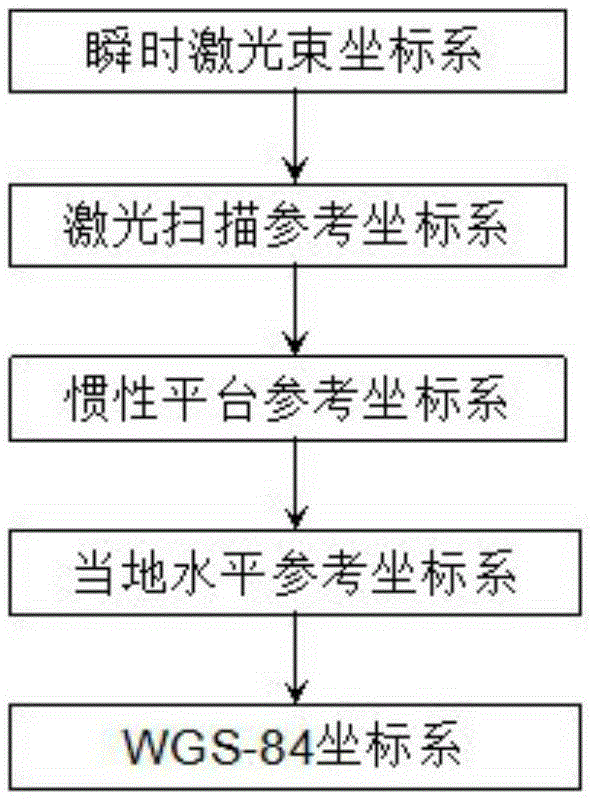
[0058] The technical solutions of the present invention will be further explained below through specific embodiments in conjunction with the accompanying drawings.

[0059] The specific steps of the laser radar coordinate conversion method based on the car body coordinate system are as follows:

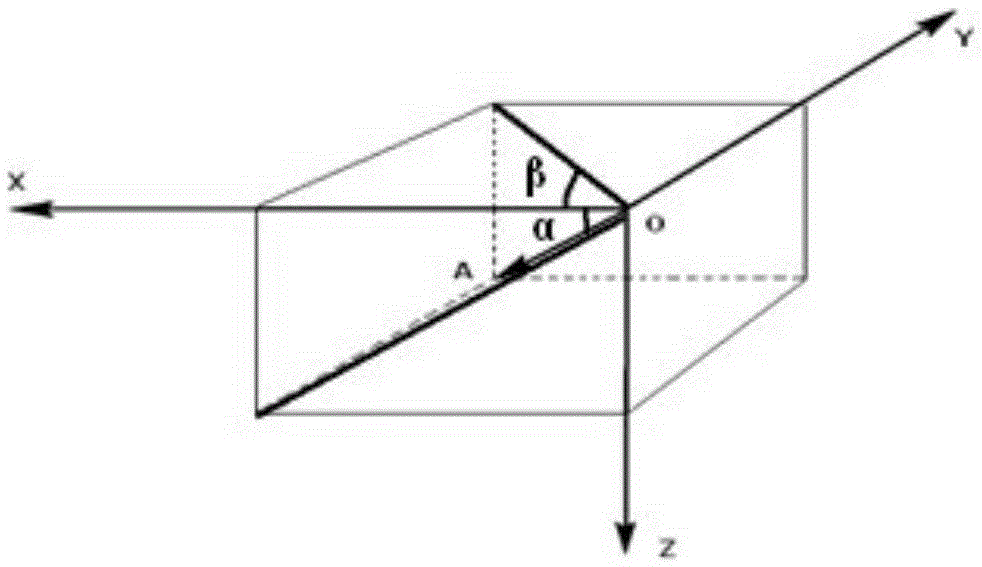
[0060] S1: The instantaneous laser beam coordinate system is transformed into the laser scanning reference coordinate system. According to the angle between the instantaneous laser and the laser radar coordinate system and the distance of the laser flight, the coordinates of the laser foot point relative to the laser radar coordinate system are calculated:

[0061] X L Y L Z L = ...


PUM


Abstract

The invention discloses a laser radar coordinate conversion method based on a vehicle body coordinate system, and the method comprises the specific steps: converting an instant laser beam coordinate system into a laser scanning reference coordinate system; solving the coordinates of a laser foot point relative to the laser radar coordinate system according to an inclined angle between the instant laser beam coordinate system and the laser radar coordinate system and a laser flight distance; converting the laser scanning reference coordinate system into an inertia platform reference coordinate system; measuring an installation inclined angle between a laser radar and an inertia navigation platform, and the displacements; solving the coordinates of the laser foot point relative to the inertia platform reference coordinate system according to a rotation and translation formula; and converting the inertia platform reference coordinate system into a period start instant coordinate system. The method does not need to convert laser foot point data into the WGS-84 coordinate system, converts the data into a vehicle carrier instant coordinate system at a starting moment of scanning, reduces the operation quantity and data dependence, and also can maintain the relative coordinates of the point relative to a vehicle. The method does not depend on GPS data, and especially avoids interpolation or prediction errors caused by GPS failures.

Description

technical field [0001] The invention relates to a coordinate conversion method, in particular to a laser radar coordinate conversion method based on a car body coordinate system. Background technique [0002] Statistics show that the number of civil vehicles in my country has reached 150 million, followed by the continuous increase of traffic accidents. According to statistics, the number of traffic accident deaths in my country has exceeded 100,000 people every year; therefore, it is necessary to use advanced technology to Ensure safe driving and reduce traffic accidents. [0003] As an important part of the intelligent transportation system, lidar plays an important role in vehicle safety and automatic driving. It can accurately measure the three-dimensional coordinates of objects in the scanning direction, and has the characteristics of high measurement accuracy and high acquisition frequency. However, the data collected by lidar needs to go through complex coordinate co...

Claims


Application Information

Patent Timeline
IPC IPC(8): G01S17/93
CPCG01S17/931
Inventor 田雨农马树发周秀田史文虎
Owner DALIAN ROILAND SCI & TECH CO LTD
Why Eureka
Try Eureka