Geographical video data organization management method supporting storage and calculation linkage
A technology for geographic video and data organization, which is applied in the field of geographic spatial information systems and can solve the problems of finding important information, such as interference, inability to highlight, and waste of storage space.
- Summary
- Abstract
- Description
- Claims
- Application Information
AI Technical Summary
Problems solved by technology
Method used
Image
Examples
Embodiment Construction
[0048] In order to facilitate those of ordinary skill in the art to understand and implement the present invention, the present invention will be described in further detail below in conjunction with the accompanying drawings and embodiments. It should be understood that the implementation examples described here are only used to illustrate and explain the present invention, and are not intended to limit this invention.
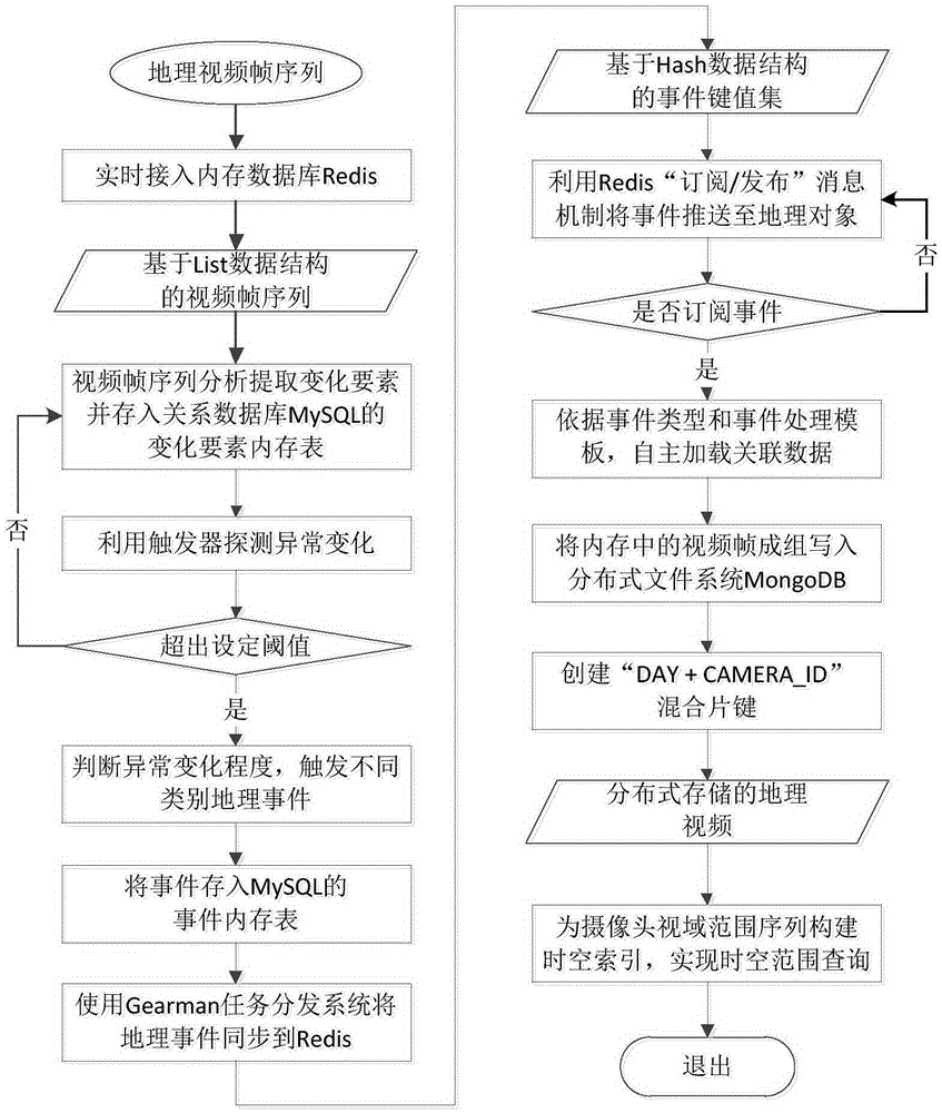
[0049] The overall process of the present invention is as figure 1 As shown, firstly, geographic video is connected to the memory database in the form of video frame sequence to support real-time access and analysis and calculation of video stream data, and then realizes real-time detection of abnormal events of changing elements through the trigger mechanism of MySQL, and through the "subscribe / publish” message mechanism pushes the event to the geographic objects that subscribe to the event, driving the procedural processing of video analysis. The focus of...
PUM
 Abstract
Description
Claims
Application Information
 - R&D
- Intellectual Property
- Life Sciences
- Materials
- Tech Scout
- Unparalleled Data Quality
- Higher Quality Content
- 60% Fewer Hallucinations
Browse by: Latest US Patents, China's latest patents, Technical Efficacy Thesaurus, Application Domain, Technology Topic, Popular Technical Reports.
© 2025 PatSnap. All rights reserved.Legal|Privacy policy|Modern Slavery Act Transparency Statement|Sitemap|About US| Contact US: help@patsnap.com


