Multiprotocol input-to-multiprotocol output and multiprotocol mutual error correction system and method

An error correction system, multi-protocol technology, applied in the field of multi-protocol input to multi-protocol output and multi-protocol mutual error correction, to achieve the effect of stable and reliable navigation signals

Inactive Publication Date: 2016-03-02
SHAANXI TIANJI COMM TECH
View PDF4 Cites 0 Cited by
  • Summary
  • Abstract
  • Description
  • Claims
  • Application Information

AI Technical Summary

Problems solved by technology

[0003] The current positioning and timing accuracy of the Beidou satellite positioning system with independent intellectual property rights in my country i

Method used


Image

  • Multiprotocol input-to-multiprotocol output and multiprotocol mutual error correction system and method
  • Multiprotocol input-to-multiprotocol output and multiprotocol mutual error correction system and method
  • Multiprotocol input-to-multiprotocol output and multiprotocol mutual error correction system and method

Examples


Embodiment 1

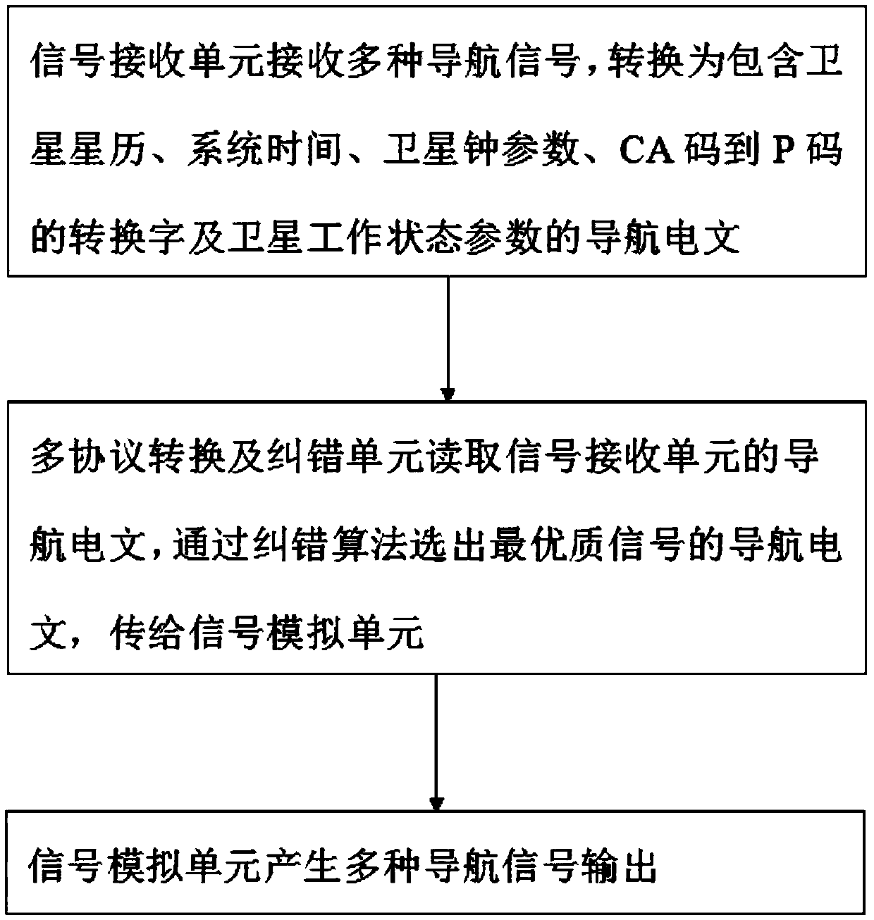
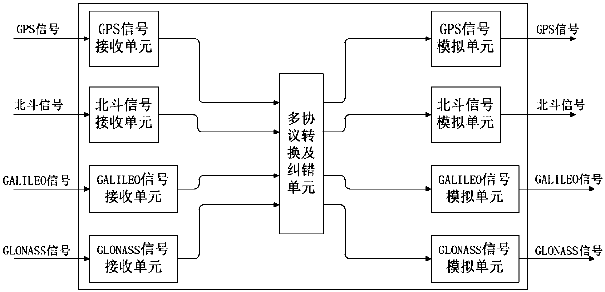
[0038] figure 2 Shown is the first embodiment of the system, including: four signal receiving units, multi-protocol conversion and error correction units and four signal simulation units.

[0039] The four signal receiving units respectively receive GPS / Beidou / GALILEO / GLONASS four navigation signals and convert them into navigation messages.

[0040] The multi-protocol conversion and error correction unit selects the navigation message of the best quality signal through the error correction algorithm, and uses the navigation message as the basis for generating the output signal, realizing the protocol error correction function.

[0041] The four signal simulation units receive the navigation message from the multi-protocol conversion and error correction unit, and generate four navigation signals: GPS / Beidou / GALILEO / GLONASS.

[0042] The working mode of the system is further described in two cases as follows:

[0043] Only one of the first and four input signals is normal, ...

Embodiment 2

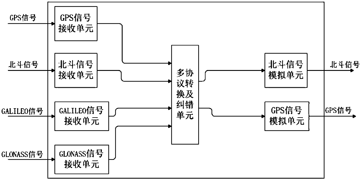
[0047] image 3 Shown is the second embodiment of the system, including: four signal receiving units, multi-protocol conversion and error correction units and two signal simulation units.

[0048] GPS / Beidou / GALILEO / GLONASS four signal receiving units can receive these four navigation signals at the same time, a GPS signal simulation unit and a Beidou signal simulation unit can output one GPS signal and one Beidou signal at the same time, this system realizes GPS / One of the four navigation signals of Beidou / GALILEO / GLONASS is converted into two navigation signals of GPS and Beidou for output. Its working mode is consistent with that described in Example 1.

Embodiment 3

[0050] Figure 4 Shown is the third embodiment of the system, including a signal receiving unit, multi-protocol conversion and error correction unit and four signal simulation units.

[0051] In this embodiment, there is only one signal receiving unit, which can simultaneously receive four navigation signals of GPS / Beidou / GALILEO / GLONASS and convert them into navigation messages.

[0052] The multi-protocol conversion and error correction unit selects the navigation message of the best quality signal through the error correction algorithm, and uses the navigation message as the basis for generating the output signal, realizing the protocol error correction function.

[0053] The four signal simulation units receive the navigation message from the multi-protocol conversion and error correction unit, and generate four navigation signals: GPS / Beidou / GALILEO / GLONASS.

[0054] The system has one input channel and four output channels, one input channel receives four kinds of navig...


PUM


Abstract

The invention provides a multiprotocol input-to-multiprotocol output and multiprotocol mutual error correction system and a method. The method particularly comprises steps: 1, a signal receiving unit receives multiple navigation signals, and the multiple navigation signals are converted into navigation messages comprising satellite ephemeris, system time, satellite clock parameters, C/A code-to-P code conversion words and satellite working state parameters; 2, a multiprotocol conversion and error correction unit reads the navigation messages of the signal receiving unit, a navigation message with the best quality signals is selected through error correction algorithm, and the navigation message is transmitted to a signal simulation unit; and 3, the signal simulation unit generates output of the multiple navigation signals. Mutual conversion of the multiple navigation signals is realized, an error correction function is provided, and multiple stable and reliable navigation signals can be ensured to be outputted at the same time.

Description

technical field [0001] The invention relates to the field of navigation, in particular to a system and method for multi-protocol input to multi-protocol output and multi-protocol mutual error correction. Background technique [0002] The world's four major navigation systems include GPS, Beidou, GALILEO, and GLONASS. Among them, the American GPS has high positioning accuracy, accurate time reception, and is the most widely used. As far as our country is concerned, 90% of communication devices use the GPS navigation system. The United States has the ability to control GPS, which will be a great threat to countries that widely use GPS navigation systems, especially in industries such as military, communication, electric power, transportation, and water conservancy. The threat is fatal. [0003] The current positioning and timing accuracy of the Beidou satellite positioning system with independent intellectual property rights in my country is already comparable to that of GPS, ...

Claims


Application Information

Patent Timeline
IPC IPC(8): G01S19/33
CPCG01S19/33
Inventor 李奎盛喻健勇肖大卫
Owner SHAANXI TIANJI COMM TECH
Why Eureka
Try Eureka