GPS and inertial measurement unit-based train combined positioning system

An inertial measurement unit and combined positioning technology, which is applied in the GPS field, can solve problems such as parallel line misidentification, signal occlusion, etc., and achieve the effects of ensuring safety, meeting system performance requirements, and high environmental adaptability

Inactive Publication Date: 2016-03-02
GUANGXI PROVINCE NANNING CITY ZHIJIANZHIFAN TECH CONSULTING
View PDF6 Cites 5 Cited by
  • Summary
  • Abstract
  • Description
  • Claims
  • Application Information

AI Technical Summary

Problems solved by technology

At present, many trains use the global positioning system. GPS can achieve high-precision and fast positioning. However, when the train enters tunnels, mountains, forests and other terrains, there are signal blocks, and it is easy to misidentify the lane on parallel lines.

Method used


Image

  • GPS and inertial measurement unit-based train combined positioning system

Examples


Embodiment Construction

[0011] The present invention is described in further detail now in conjunction with accompanying drawing. These drawings are all simplified schematic diagrams, which only illustrate the basic structure of the present invention in a schematic manner, so they only show the configurations related to the present invention.

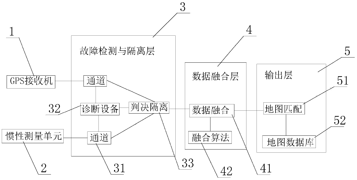
[0012] like figure 1 A combined train positioning system based on GPS and inertial measurement unit is shown, including GPS receiver 1, inertial measurement unit 2, fault detection and isolation layer 3, data fusion layer 4 and output layer 5, output layer 5 includes map matching 51 and map database 52 connected with map matching 51, GPS receiver 1 and inertial measurement unit 2 are connected with fault detection and isolation layer 3, fault detection and isolation layer 3 includes several channels 31 and several diagnostic equipment 32 and Judgment isolation 33, several channels 31 and several diagnostic devices 32 are respectively connected with the judgme...


PUM


Abstract

The invention relates to a GPS and inertial measurement unit-based train combined positioning system. The GPS and inertial measurement unit-based train combined positioning system includes a GPS receiver, an inertial measurement unit, a fault detection and isolation layer, a data fusion layer and an output layer; the output layer includes a map matching unit and a map database connected with the map matching unit; the GPS receivers and the inertial measurement unit are connected with the fault detection and isolation layer; the fault detection and isolation layer is connected with the data fusion layer; the data fusion layer is connected with the map matching unit; and positioning output is carried out. With the GPS and inertial measurement unit-based train combined positioning system adopted, high-precision and high-reliability train positioning can be realized; and under different train positioning conditions, system performance requirements can be satisfied, and security can be ensured. The GPS and inertial measurement unit-based train combined positioning system has high environmental adaptability and high practical application value.

Description

technical field [0001] The invention relates to the field of GPS, in particular to a combined train positioning system based on GPS and an inertial measurement unit. Background technique [0002] The real-time positioning of trains mainly relies on technologies such as odometers, interrogation transponders, and global navigation satellite systems. Communication-based train control systems need to continuously update train positions with appropriate accuracy and sufficient integrity, which brings challenges to train positioning systems. higher requirement. At present, many trains use the global positioning system. GPS can achieve high-precision and fast positioning. However, when the train enters tunnels, mountains, forests and other terrains, there are signal blocks, and it is easy to misidentify the lane on parallel lines. Contents of the invention [0003] The technical problem to be solved by the present invention is: in order to overcome the above-mentioned problems, ...

Claims


Application Information

Patent Timeline
Patent Type & Authority Applications(China)
IPC IPC(8): G01S19/49G01S19/50G01C21/16
CPCG01S19/49G01C21/165G01S19/50
Inventor 刘静兰
Owner GUANGXI PROVINCE NANNING CITY ZHIJIANZHIFAN TECH CONSULTING
Why Eureka
Try Eureka