Multispectral satellite image distance deviation index defogging method

A technology of distance deviation index and satellite imagery, applied in the field of optical satellite imagery image processing, can solve problems such as poor fog effect

Active Publication Date: 2016-03-16
THE PLA INFORMATION ENG UNIV
View PDF3 Cites 4 Cited by
  • Summary
  • Abstract
  • Description
  • Claims
  • Application Information

AI Technical Summary

Problems solved by technology

[0004] The purpose of the present invention is to overcome the deficiencies in the prior art, and proposes a multi-spectral satellite image distance deviation index defogging method, which solves the problem of removing the fog in the satellite multi-spectral image when the impact of haze is relatively serious or the distribution of clouds and fog is uneven in the prior art. The technical problem of poor fog effect

Method used


Image

  • Multispectral satellite image distance deviation index defogging method
  • Multispectral satellite image distance deviation index defogging method
  • Multispectral satellite image distance deviation index defogging method

Examples


Embodiment Construction

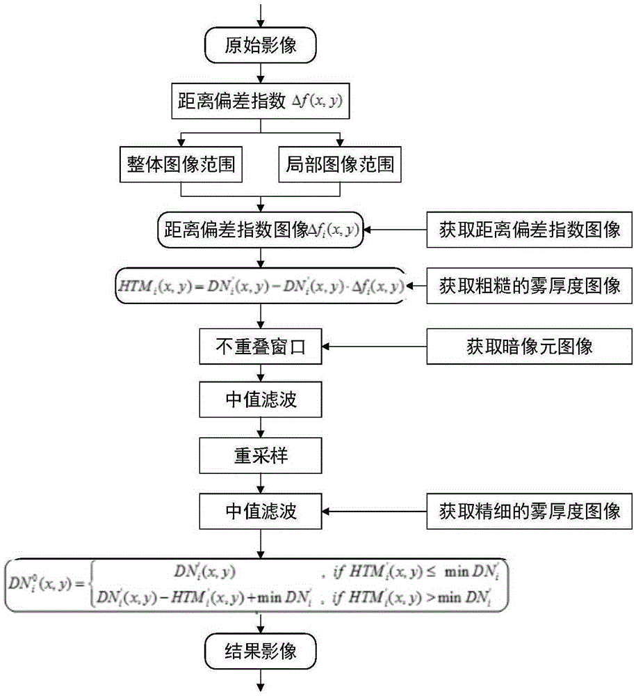
[0061] The present invention will be described in further detail below in conjunction with the accompanying drawings and embodiments.

[0062] The method of defogging by distance deviation index for multispectral satellite imagery, the specific steps are as follows:

[0063] 1. For satellite imagery, because it contains complex ground objects and has a wide distribution range, the pixel gray value changes of clouds and fog are inconsistent in different regions, so it is difficult to directly distinguish between clouds and fog and their underlying areas by setting thresholds normal surface. Therefore, in this embodiment, for the original multi-spectral satellite image, analyze the variation relationship of the distance deviation index Δf(x, y) of the current pixel point (x, y) of the original image from the overall image and the local area, and calculate the ith The distance deviation index image Δf of the band i (x, y), by calculating the distance deviation index to weaken t...


PUM


Abstract

The invention relates to a multispectral satellite image distance deviation index defogging method. A distance deviation index is set based on the difference of the gray values of the fog-containing area and a landmark area of an original multispectral satellite image; and the distance deviation index is applied to the local range of the original spectral satellite image and is further improved. A rough fog thickness image is calculated based on the improved distance deviation index and is subjected to refining processing, the refined fog thickness image is removed from the original spectral satellite image, and then the defogging of the original multispectral satellite image is realized. The method is high in universality and can effectively weaken consistency influence in the original image fogging area, so that the real spectrum information of the earth surface under the fog is recovered and a high-quality and clear earth surface satellite image can be obtained.

Description

technical field [0001] The invention relates to a multi-spectral satellite image distance deviation index defogging method, belonging to the technical field of optical satellite image image processing. Background technique [0002] In the near-Earth space environment, the influence of clouds and fog directly causes the quality degradation and blurring of optical remote sensing satellite images, which seriously hinders the preprocessing of images such as atmospheric correction, matching, and positioning, and subsequent practical applications. In the prior art, the processing of clouds and fog in satellite images is mainly through the following three aspects: (1) based on the imaging characteristics of fog such as blur and slow change, the frequency domain transformation algorithm is used to eliminate the low frequency components in the frequency domain; (2) The correlation between image bands is used to distinguish clouds, fog and real ground in the spatial domain; (3) Based ...

Claims


Application Information

Patent Timeline
Patent Type & Authority Applications(China)
IPC IPC(8): G06T5/00
CPCG06T5/003G06T5/008G06T5/20G06T2207/10036G06T2207/20032
Inventor 周杨许继伟徐青张衡蓝朝桢李鹏飞赵玲薛现光胡校飞
Owner THE PLA INFORMATION ENG UNIV
Why Eureka
Try Eureka