Shipborne all-time starlight and inertia combined navigation system

A technology of integrated navigation system and inertial navigation system, which is applied in the field of ship-borne all-day starlight inertial navigation integrated navigation system, can solve the problems of accuracy dependence, heavy weight of the integrated navigation system, and difficulty in working all day, etc., and meets the index requirements The effect of reducing and ensuring accuracy

Active Publication Date: 2016-03-23
BEIJING INST OF CONTROL ENG
View PDF4 Cites 10 Cited by
  • Summary
  • Abstract
  • Description
  • Claims
  • Application Information

AI Technical Summary

Problems solved by technology

The application of this integrated navigation method is relatively mature, but the accuracy of the integrated system depends on the accuracy of the inertial navigation system. The high-precision inertial navigation system weighs a lot, so the integrated navigation system also weighs a lot. Due to the influence of scattered light from the sun, it is difficult to work all day long, and it is mostly used to complete navigation tasks in near space

Method used


Image

  • Shipborne all-time starlight and inertia combined navigation system

Examples


Embodiment Construction

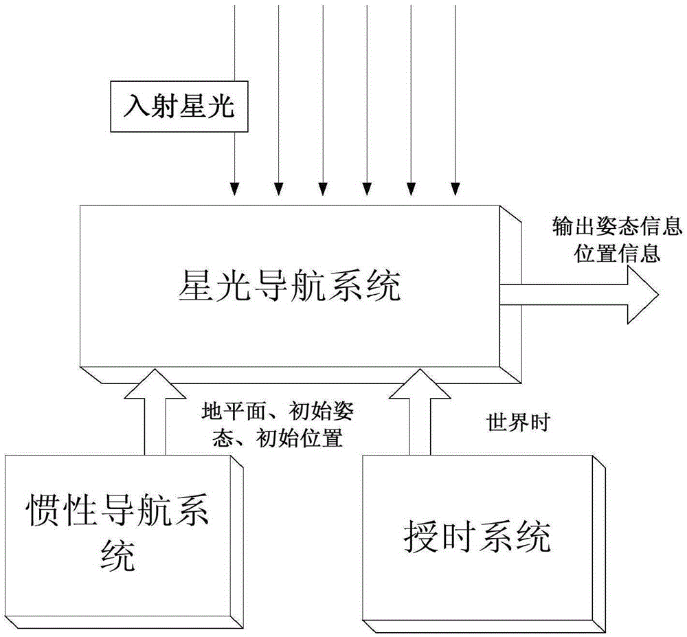
[0024] The present invention provides a structural block diagram of a ship-borne all-sky starlight inertial navigation integrated navigation system. Through the improvement of the starlight navigation system, it has the ability to detect at least two stars in the whole sky. The working mode is mainly starlight navigation and inertial navigation. Assist in providing ground level information and rough posture. The integrated navigation system of the present invention will be described in detail below with reference to the accompanying drawings.

[0025] Such as figure 1 The combined navigation system of the present invention shown includes a starlight navigation system, an inertial navigation system, and a timing system. The starlight navigation system includes an optical system, a detection circuit, and an image processing module.

[0026] The function of the optical system is to receive incident starlight from different angles and converge it on the photosensitive surface of the d...


PUM


Abstract

A shipborne all-time starlight and inertia combined navigation system comprises a starlight navigation system, an inertia navigation system and a time-giving system, wherein the starlight navigation system comprises an optical system, a detection circuit and an image processing module, the inertia navigation system provides coarse gestures for the starlight navigation system and can decrease the error matching probability and matching speed of the starlight navigation system, the time-giving system provides universal time and pulse per second and is used for an ITRS coordinate system and an ICRS coordinate system, the pulse per second is used for synchronization of work cycles of the combined navigation system, and the starlight navigation system calculates high-precision navigation information and conducts output. According to the shipborne all-time starlight and inertia combined navigation system, the mode of combining the starlight navigation system with the inertia navigation system is adopted, the near-infrared band is selected to serve as the working band so that the combined navigation system can work under the all-time condition, miniaturization of the navigation system is achieved, and meanwhile high precision of the navigation system is further guaranteed.

Description

Technical field [0001] The invention relates to an all-weather ship-borne autonomous navigation technology, belonging to the field of navigation control, in particular to a ship-borne all-weather starlight inertial navigation integrated navigation system. Background technique [0002] Traditional navigation is the process of guiding the carrier from the starting point to the destination according to predetermined plans and requirements. The equipment used to complete the above guidance tasks is collectively referred to as a navigation system. The existing navigation systems include inertial navigation (INS), satellite navigation, star navigation (CNS), terrain assisted navigation (TAN), etc., each of which has its advantages and disadvantages. [0003] The advantages of the inertial navigation system are complete autonomy, good concealment, complete navigation information, high short-term accuracy, high data output rate, etc., but its error diverges with time and can only achieve ...

Claims


Application Information

Patent Timeline
Patent Type & Authority Applications(China)
IPC IPC(8): G01C21/16G01C21/02
CPCG01C21/02G01C21/165
Inventor 孙大开王立武延鹏左富昌张运方鹿瑞白山
Owner BEIJING INST OF CONTROL ENG
Why Eureka
Try Eureka