Miniature unmanned plane RTK relative positioning method based on difference air pressure height constraints

A technology of small unmanned aerial vehicle and air pressure altitude, which is applied in the field of satellite navigation and positioning, and can solve the problems of not being able to equip measuring receivers, reducing the success rate of ambiguity in the whole circle, and being unable to effectively guarantee RTK positioning accuracy, etc.

Inactive Publication Date: 2016-04-06
CIVIL AVIATION UNIV OF CHINA
View PDF4 Cites 16 Cited by
  • Summary
  • Abstract
  • Description
  • Claims
  • Application Information

AI Technical Summary

Problems solved by technology

[0004] However, due to cost and volume constraints, small UAVs are usually equipped with a navigation receiver, but cannot be equipped with a measurement receiver with multipath suppression function, so the multipath error cannot be reduced, which leads to the use of the LAMBD

Method used


Image

  • Miniature unmanned plane RTK relative positioning method based on difference air pressure height constraints
  • Miniature unmanned plane RTK relative positioning method based on difference air pressure height constraints
  • Miniature unmanned plane RTK relative positioning method based on difference air pressure height constraints

Examples


Embodiment Construction

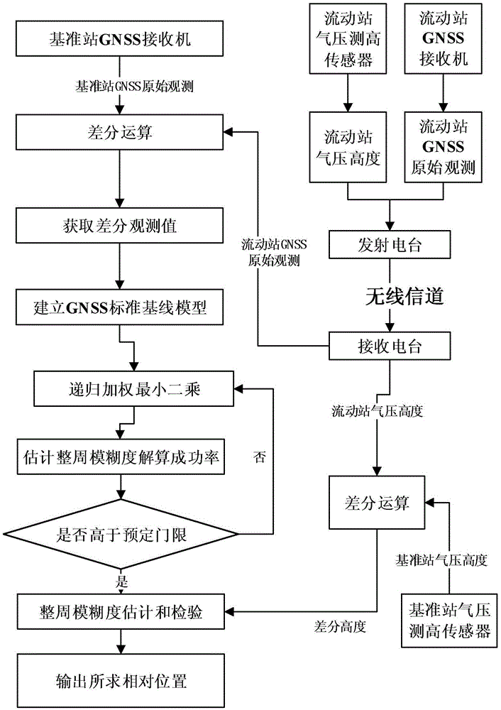
[0036] Such as figure 1 As shown, the real-time dynamic relative positioning method based on the differential pressure altitude constraint provided by the present invention includes the following steps carried out in order:

[0037] 1) Install the GNSS receiver, GNSS antenna, barometric altimeter sensor and receiving station on the base station, wherein the GNSS antenna and the barometric altimeter sensor are at the same height, use the GNSS receiver and GNSS antenna to obtain the original GNSS observation value of the base station, and at the same time Measuring the Barometric Altitude H of the Reference Station Using the Barometric Altimeter Sensor base , the height measurement accuracy is σ H ;

[0038] 2) GNSS receiver, GNSS antenna, barometric altimetry sensor and transmitting station of the same model as described in step 1) are installed on the mobile station, that is, a small unmanned aerial vehicle, wherein the GNSS antenna and barometric altimeter are at the same h...


PUM


Abstract

Provided is a miniature unmanned plane RTK relative positioning method based on difference air pressure height constraints, comprising: installing GNSS receivers of a same model, antennas, barometric leveling sensors and radio stations both on a reference station and a mobile station; transmitting the GNSS original observed value of the mobile station to the reference station, and performing difference recursion treatment on the original observed value of the reference station; employing an LAMBDA algorithm to determine N baseline vector residence values, respectively calculating the difference vector with a baseline vector floating point solution, and performing ordering again according to the absolute value sum of north and east components; transmitting the barometric height of the mobile station to the reference station through the radio stations, and performing difference with the barometric height of the reference station to obtain a difference height; and successively examining the sky direction component of a baseline vector fixed solution, and determining a relative position if meeting difference height constrains. The miniature unmanned plane RTK relative positioning method can utilize the difference height information of the reference station and the mobile station to discriminate a correct baseline vector fixed solution, does not need to use a measurement type receiver with a multi-path inhibition function, and can be used for low cost RTK application.

Description

technical field [0001] The invention relates to an RTK relative positioning method for a small unmanned aerial vehicle based on differential air pressure altitude constraints, and belongs to the technical field of satellite navigation and positioning. Background technique [0002] At present, small UAVs have been widely used in surveying and mapping, aerial photography, monitoring, investigation, communication relay and other fields. The real-time positioning and navigation system is a key system of small UAVs. Since the Global Navigation Satellite System (GNSS) has global, all-weather and continuous precise three-dimensional positioning capabilities, satellite navigation systems represented by GPS and Beidou have been widely used in various fields in the past ten years. The GNSS receiver adopts single-point positioning technology, and the accuracy is generally 3 to 10 meters, but its disadvantage is that it cannot realize sub-centimeter-level high-precision navigation appli...

Claims


Application Information

Patent Timeline
IPC IPC(8): G01S19/41G01S19/44G01S19/51G01C5/06
CPCG01C5/06G01S19/41G01S19/44G01S19/51
Inventor 陈万通韩萍吴仁彪
Owner CIVIL AVIATION UNIV OF CHINA
Why Eureka
Try Eureka