Remote sensing technology based ancient wind strength quantification reconstruction method
A technology of paleowind intensity and remote sensing technology, applied in the field of quantitative reconstruction of paleowind intensity based on remote sensing technology, to achieve reliable accuracy evaluation and reduce human error
- Summary
- Abstract
- Description
- Claims
- Application Information
AI Technical Summary
Problems solved by technology
Method used
Image
Examples
Embodiment Construction
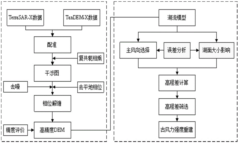
[0033] The present invention applies remote sensing technology to the quantitative reconstruction of paleowind intensity for the first time. The reconstruction method is to establish a lake flow model on the basis of the high-precision DEM generated first, and then through error analysis, elevation difference calculation and screening, and finally complete the paleowind intensity. Quantitative reconstruction of wind intensity.
[0034] Refer to attached figure 1 As shown, the specific technical process of the quantitative reconstruction method of paleowind intensity based on remote sensing technology in the present invention includes the following steps:
[0035] The first step is to obtain the TerraSAR-X / TanDEM-X long-baseline interference pair data in the study area. According to the introduction of the background technology of this application, the TerraSAR-X satellite and the TanDEM-X satellite launched by the German Space Agency fly in formation to build a dual-station S...
PUM
 Abstract
Description
Claims
Application Information
 - R&D
- Intellectual Property
- Life Sciences
- Materials
- Tech Scout
- Unparalleled Data Quality
- Higher Quality Content
- 60% Fewer Hallucinations
Browse by: Latest US Patents, China's latest patents, Technical Efficacy Thesaurus, Application Domain, Technology Topic, Popular Technical Reports.
© 2025 PatSnap. All rights reserved.Legal|Privacy policy|Modern Slavery Act Transparency Statement|Sitemap|About US| Contact US: help@patsnap.com


