Supercharge Your Innovation With Domain-Expert AI Agents!

Video mapping system based on barrier-free navigation airship

A map drawing and barrier-free technology, applied in the field of aircraft, can solve the problems of no spatial location information, unable to make video maps, etc., and achieve the effect of avoiding falling

Active Publication Date: 2016-05-25
SHENZHEN INST OF ADVANCED TECH
View PDF3 Cites 13 Cited by
  • Summary
  • Abstract
  • Description
  • Claims
  • Application Information

AI Technical Summary

Problems solved by technology

[0003] The existing video data captured by the airship has no spatial location information, and it is impossible to use the video data captured by the airship to make a video map

Method used


Image

  • Video mapping system based on barrier-free navigation airship

Examples


Embodiment Construction

[0023] In order to make the object, technical solution and advantages of the present invention clearer, the present invention will be further described in detail below in conjunction with the accompanying drawings and embodiments. It should be understood that the specific embodiments described here are only used to explain the present invention, not to limit the present invention.

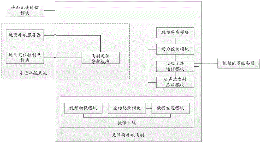
[0024] see figure 1 , is a schematic structural diagram of a video map drawing system based on an barrier-free navigation airship according to an embodiment of the present invention. The video map drawing system based on the barrier-free navigation airship of the embodiment of the present invention includes an airship, a positioning and navigation system, a wireless communication system, a camera system, and a video map server; wherein, the positioning and navigation system consists of an airship positioning and navigation module, a ground positioning control point module, The ground navigation se...


PUM


Abstract

This invention relates to a video mapping system based on a barrier-free navigation airship. The system comprises a barrier-free navigation airship, an airship wireless communication module, a camera system and a video mapping server; the airship wireless communication module and the camera system are arranged on the barrier-free navigation airship; the camera system is connected with the video mapping system through the airship wireless communication module; the camera system is used for shooting flight video data of the airship, recording time and space information of the airship, and sending the shot video data, the time and space information to the video mapping server through the airship wireless communication module; and the video mapping server is used for automatically drawing the video map according to the video data and the space-time coordinate information. By installing the camera system on a rotor airship to collect indoor (outdoor) three-dimensional space video and to form the video map, the system replaces an unmanned plane to shoot, and has the advantages of safety, stability, sustainability, high quality, automatic control, etc.

Description

technical field [0001] The invention belongs to the technical field of aircraft, and in particular relates to a video map drawing system based on a barrier-free navigation airship. Background technique [0002] As a widely used aircraft, the airship has the ability to suspend in the air, and it is easy to operate and drive. It can fly at low altitude and low speed. . [0003] The existing video data captured by the airship has no spatial location information, and the video data captured by the airship cannot be used to make a video map. Contents of the invention [0004] The present invention provides a video map drawing system based on a barrier-free navigation airship, aiming to solve the above-mentioned problems in the prior art at least to a certain extent. [0005] The implementation of the present invention is as follows: a video map drawing system based on a barrier-free navigation airship, including a barrier-free navigation airship, an airship wireless communica...

Claims


Application Information

Patent Timeline
IPC IPC(8): H04N13/02H04N5/76G01C21/00
CPCG01C21/00H04N5/76H04N13/20
Inventor 修文群
Owner SHENZHEN INST OF ADVANCED TECH
Features
  • R&D
  • Intellectual Property
  • Life Sciences
  • Materials
  • Tech Scout
  • Unparalleled Data Quality
  • Higher Quality Content
  • 60% Fewer Hallucinations
Learn More