BIM-based three-dimensional geological automatic modeling method

A modeling method and 3D geological technology, applied in 3D modeling, image data processing, instruments, etc., can solve the problems of heavy modeling workload, error-prone, difficult, etc., to improve modeling accuracy, fast and automatic modeling , easy to integrate the display effect

Inactive Publication Date: 2016-06-01
上海顺凯信息技术有限公司
View PDF4 Cites 29 Cited by
  • Summary
  • Abstract
  • Description
  • Claims
  • Application Information

AI Technical Summary

Problems solved by technology

[0003] 1) Manual input of drilling data and manual modeling of rock and soil layers, the modeling workload is heavy and cumbersome, error-prone, and modeling efficiency is low;
[0004] 2) When building a 3D geological model, it can only deal with conventional rock and soil strata, and it is difficult to deal with common phenomena such as lens and pinch-out rock and soil strata, and only rough modeling of rock and soil strata can be performed;
[0005] 3) Using Revit software to simulate foundation pit excavation can only be done manually for one rock and soil layer at the same time;
[0006] 4) Lack of calculation and model output interfaces related to geotechnical engineering investigation

Method used


Image

  • BIM-based three-dimensional geological automatic modeling method

Examples


Embodiment

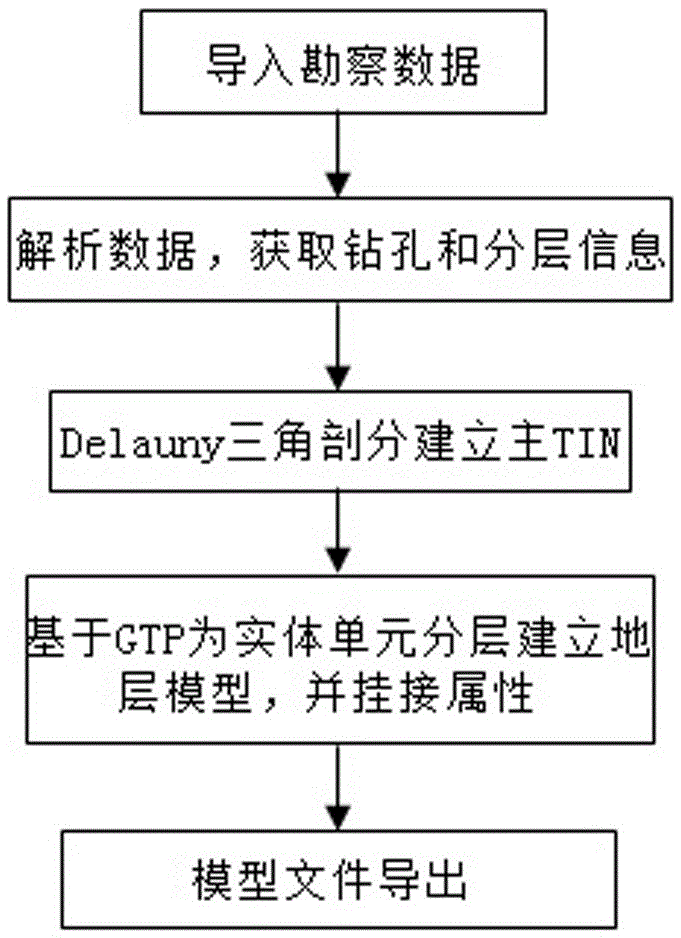
[0024] Example: such as figure 1 As shown, in the present invention, the BIM-based three-dimensional geological automatic modeling method seamlessly connects to the geological database, and the modeling data comes from geological data such as exploration hole data, site layering data, plane hole layout coordinates, and profiles in the survey geological database. Modelers only need to retrieve the engineering geological data to be constructed in the database according to the engineering number index, and then they can carry out automatic modeling, without manual data preprocessing such as drilling identification and stratum division, including the following steps:

[0025] Import relevant data into the survey geological data server through the survey geological survey information processing software, connect to the survey geological database according to the configuration file, and use the WCF service function deployed on the server side to analyze the survey data such as drilli...


PUM


Abstract

The invention relates to the field of BIM automatic modeling, and especially relates to a BIM-based three-dimensional geological automatic modeling method. The method is characterized in that the method at least comprises the following steps: acquiring prospecting data, i.e., introducing a prospecting geological or boring data source file into a geological database; and scheduling the geological database and performing modeling, i.e., a Revit platform obtaining the prospecting geological or boring data source file I from the geological database and performing modeling according to the source file. The method provided by the invention has the following advantages: a three-dimensional geological model is constructed and generated automatically and rapidly out of the prospecting data, the process includes entity construction, material rendering, attribute modeling and the like, users are enabled to browse from a three-dimensional angle and manage prospecting accomplishments, and the effect of BIM demonstrated in the field of engineering prospecting is further tapped.

Description

technical field [0001] The invention relates to the field of BIM automatic modeling, in particular to a BIM-based three-dimensional geological automatic modeling method. Background technique [0002] With the deepening application of BIM in construction engineering, especially geotechnical engineering, more and more customers need to model the formation. In the process of 3D visualization of geotechnical engineering survey and geological results, direct use of Revit software for manual modeling has certain limitations, as follows: [0003] 1) Manual input of drilling data and manual modeling of rock and soil layers, the modeling workload is heavy and cumbersome, error-prone, and modeling efficiency is low; [0004] 2) When building a 3D geological model, it can only deal with conventional rock and soil strata, and it is difficult to deal with common phenomena such as lens and pinch-out rock and soil strata, and only rough modeling of rock and soil strata can be performed; ...

Claims


Application Information

Patent Timeline
Patent Type & Authority Applications(China)
IPC IPC(8): G06T17/05
CPCG06T17/05
Inventor 毛维辰易爱华雷文敏
Owner 上海顺凯信息技术有限公司
Why Eureka
Try Eureka