Massive topographic data organization and release method

A topographic data and organization technology, applied in the direction of electrical digital data processing, special data processing applications, instruments, etc., can solve the problems of losing block independence, reducing storage space, affecting efficiency, etc., to facilitate update and maintenance, and improve access efficiency , the effect of efficient data support

Active Publication Date: 2016-06-29
星际空间(天津)科技发展有限公司
View PDF4 Cites 15 Cited by
  • Summary
  • Abstract
  • Description
  • Claims
  • Application Information

AI Technical Summary

Problems solved by technology

[0006] 1), multi-layer DOM resampling and image fusion problems:
Whether it is adding a point or removing a point, it is necessary to traverse the entire terrain and re-triangulate the relevant blocks, which loses the independence of the blocks, increases the pressure on the cache, and increases the complexity of the problem, which in turn affects to efficiency
[0011] 3) The problem of fast storage of block data:
[0013] 4), Custom clipping area and incremental release issues:
[0014] Custom clipping area means that when publishing terrain data, sometimes only the area of ​​interest (rectangular or polygonal) needs to be processed and published to the database. How to solve the grading and block processing of local irregular images is a relatively cumbersome matter
[0015] However, domestic related data release systems are relatively inefficient in processing massive ter

Method used


Image

  • Massive topographic data organization and release method
  • Massive topographic data organization and release method
  • Massive topographic data organization and release method

Examples


Embodiment 1

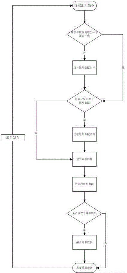
[0076] figure 1 It is a schematic flowchart of a method for organizing and publishing massive terrain data provided in this embodiment. Such as figure 1 As shown, a method for organizing and releasing massive terrain data includes the following steps:

[0077] A method for organizing and releasing massive terrain data, characterized in that it comprises the following steps:

[0078] Read terrain data: read orthophoto and digital elevation image data, and read one image or multiple images at the same time during image reading. The resolution of each image can be different, and the resolution of each image can be different. The range can also be repeated to form one or more layers of terrain data;

[0079] Unified terrain data coordinates: judge whether the geographic coordinate system of the image is consistent, if it is judged to be yes, proceed to the next step, if not, convert its data coordinates to a unified geographic coordinate system;

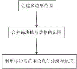
[0080] Select the range of te...

Embodiment 2

[0127] figure 2 It is a schematic flowchart of a method for organizing and publishing massive terrain data provided in this embodiment. Such as figure 1 As shown, a method for organizing and releasing massive terrain data includes the following steps:

[0128] A method for organizing and releasing massive terrain data, characterized in that it comprises the following steps:

[0129] Read terrain data: read orthophoto and digital elevation image data, and read one image or multiple images at the same time during image reading. The resolution of each image can be different, and the resolution of each image can be different. The range can also be repeated to form one or more layers of terrain data;

[0130] Unified terrain data coordinates: judge whether the geographic coordinate system of the image is consistent, if it is judged to be yes, proceed to the next step, if not, convert its data coordinates to a unified geographic coordinate system;

[0131] Select the range of t...


PUM


Abstract

The invention discloses a massive topographic data organization and release method, and relates to the technical field of processing and application of geographic information. The massive topographic data organization and release method is characterized by comprising the following steps of reading topographic data, unifying topographic data coordinates, selecting a topographic data range, establishing index information, resampling the topographic data, fusing the topographic data and releasing the topographic data, which form a complete process. The massive topographic data organization and release method has the superiority that the technical problems that organization structure construction of the massive topographic data can be convenient for updating, rapid retrieval and acquisition of the data and the like can be simultaneously solved. Meanwhile, images can be compressed, edge-matched and fused, a storage space is reduced, access efficiency is improved, and the massive topographic data organization and release method is convenient for updating and maintenance; the massive topographic data can be subjected to multi-platform data release and sharing; and safe, reliable, accurate and efficient data support is provided for deep application in different industries.

Description

technical field [0001] The present invention relates to the technical field of geographic information processing and application, in particular to a management based on geographic information data, image compression, edge joining and fusion, reducing storage space, improving access efficiency, facilitating update and maintenance, efficient organization of massive terrain data, A method of organizing and releasing massive terrain data for management and release. Background technique [0002] Geographic Information System (Geographic Information System or Geo-Information system, GIS) is sometimes called "geoscience information technology" or "resource and environmental information technology". It is a specific and very important spatial information technology. It is a technical method to collect, store, manage, calculate, analyze, display and describe the relevant geographical distribution data in the space of the whole or part of the earth's surface (including the atmosphere...

Claims


Application Information

Patent Timeline
IPC IPC(8): G06F17/30
Inventor 蔡红高健黄恩兴辛全波沈迎志沈美岑周新鹤王梦
Owner 星际空间(天津)科技发展有限公司
Why Eureka
Try Eureka