A Fishing Ground Forecasting Method Using Multi-scale Environmental Features

An environmental feature and multi-scale technology, applied in nuclear methods, forecasting, data processing applications, etc., can solve problems such as inability to achieve effective forecasting, achieve important scientific value and economic and social benefits, and improve accuracy

Active Publication Date: 2019-08-20
EAST CHINA SEA FISHERIES RES INST CHINESE ACAD OF FISHERY SCI
View PDF4 Cites 0 Cited by
  • Summary
  • Abstract
  • Description
  • Claims
  • Application Information

AI Technical Summary

Problems solved by technology

The mapping model established by using a few marine environmental parameters with a fixed grid size and a single temporal-spatial resolution can only reflect a partial spatial subset of the distribution characteristics of marine fisheries, and cannot achieve effective forecasting for the characteristic spatial areas of fisheries that are not covered.

Method used


Image

  • A Fishing Ground Forecasting Method Using Multi-scale Environmental Features
  • A Fishing Ground Forecasting Method Using Multi-scale Environmental Features
  • A Fishing Ground Forecasting Method Using Multi-scale Environmental Features

Examples


Embodiment Construction

[0026] In order to make the technical means, creative features, goals and effects achieved by the present invention easy to understand, the present invention will be further described below in conjunction with specific embodiments.

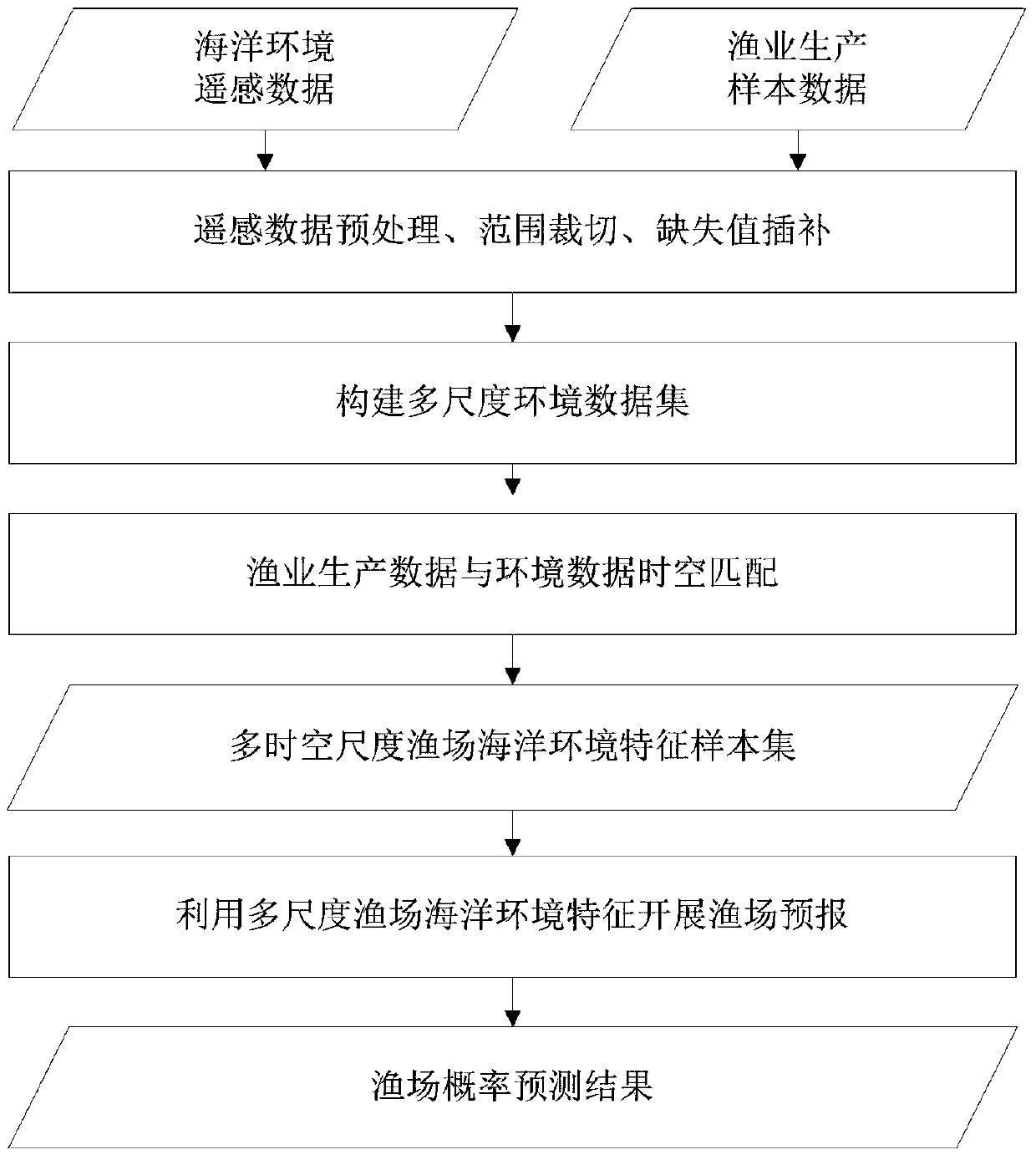
[0027] see figure 1 , a fishery forecasting method using multi-scale environmental features of the present invention, comprising the following steps:

[0028] (1) Preprocessing the marine remote sensing multi-environmental element products obtained by satellite remote sensing technology. In a specific embodiment, sea surface environmental data include but not limited to chlorophyll a, sea surface temperature, and sea surface height.

[0029] Data clipping: In this example, the routine operation range of the South China Sea fishery is cut according to the latitude and longitude range of 105°E-130°E, 0°N-30°N, and a subset of environmental data of the South China Sea operation area is obtained.

[0030] Data interpolation: Because the remote sensin...


PUM


Abstract

The invention discloses a fishing ground forecast method utilizing multi-scale environmental characteristics, comprising the following steps: 1) preprocessing the original marine environment remote sensing data of the target area; 2) constructing a multi-scale environment based on the preprocessed marine environment remote sensing data Feature data set; 3) Calculate CPUE per unit fishing effort based on fishery production data, and set a threshold according to the CPUE distribution to generate fishery sample labels; 4) Search for oceans that are close to or meet the threshold in the multi-scale environmental feature data set Based on environmental remote sensing data, a multi-temporal-spatial scale fishery marine environment characteristic sample set is established; 5) Fishery forecast is carried out based on the multi-temporal-spatial scale fishery marine environmental characteristic sample set, and the fishery probability forecast result is obtained. The invention establishes an effective mapping from the multi-dimensional ocean environment feature space to the ocean fishery feature space, so that the mapping relationship can reflect the distribution law of the ocean fishery more robustly and comprehensively, and improves the accuracy of the fishery forecast.

Description

technical field [0001] The invention relates to the field of marine fishery forecasting, in particular to a fishery forecasting method utilizing multi-scale environmental features. Background technique [0002] Providing marine environment information such as the abundance distribution of marine fishery resources and marine hydrometeorology to fishermen or fishing fleets engaged in marine fishing production can effectively reduce the time for fishing at sea, save fuel and reduce labor costs, and improve fishing efficiency. Economic value and social benefits. Existing technologies focus on the entire fishing area as an object, using single-resolution marine environmental parameters and fishery production data with a fixed grid size, and performing marine environment analysis and fishery forecasting through traditional statistical learning models. [0003] The distribution and changes of marine fisheries are closely related to various marine environmental factors at different...

Claims


Application Information

Patent Timeline
Patent Type & Authority Patents(China)
IPC IPC(8): G06N20/10G06Q10/04G06Q50/02G06K9/62
CPCG06Q10/04G06Q50/02G06F18/2411
Inventor 周为峰王鲁民樊伟郑汉丰
Owner EAST CHINA SEA FISHERIES RES INST CHINESE ACAD OF FISHERY SCI
Why Eureka
Try Eureka