
Positioning method and device based on pseudorange and linear vector

A positioning method and pseudo-range technology, applied in the field of satellite positioning and inertial navigation, can solve the problems of difficult long-term stable positioning, harsh requirements of inertial navigation system, high cost, etc., to improve positioning coverage, expand positioning coverage, and high commercial use value effect

Inactive Publication Date: 2016-07-27
BEIJING UNIV OF POSTS & TELECOMM
View PDF0 Cites 4 Cited by
  • Summary
  • Abstract
  • Description
  • Claims
  • Application Information

AI Technical Summary

Problems solved by technology

There are many shortcomings in these methods, such as simply improving the receiving sensitivity is difficult to solve the problem that some satellite signals are completely blocked, the integrated navigation of radio navigation, astronomical navigation and inertial navigation, the system is complex, the system is huge, the cost is expensive, the schedule maintenance is complicated, and the working conditions Special, high power consumption, etc., difficult to promote on a large scale
Due to the long-term cumulative error and poor long-term stability of the inertial navigation system, the current satellite and inertial navigation integrated navigation system has strict requirements on the inertial navigation system and is expensive, and due to the error accumulation effect, it can only be used in a very short time when the satellite positioning disappears. It is difficult to perform long-term stable positioning for position estimation

Method used

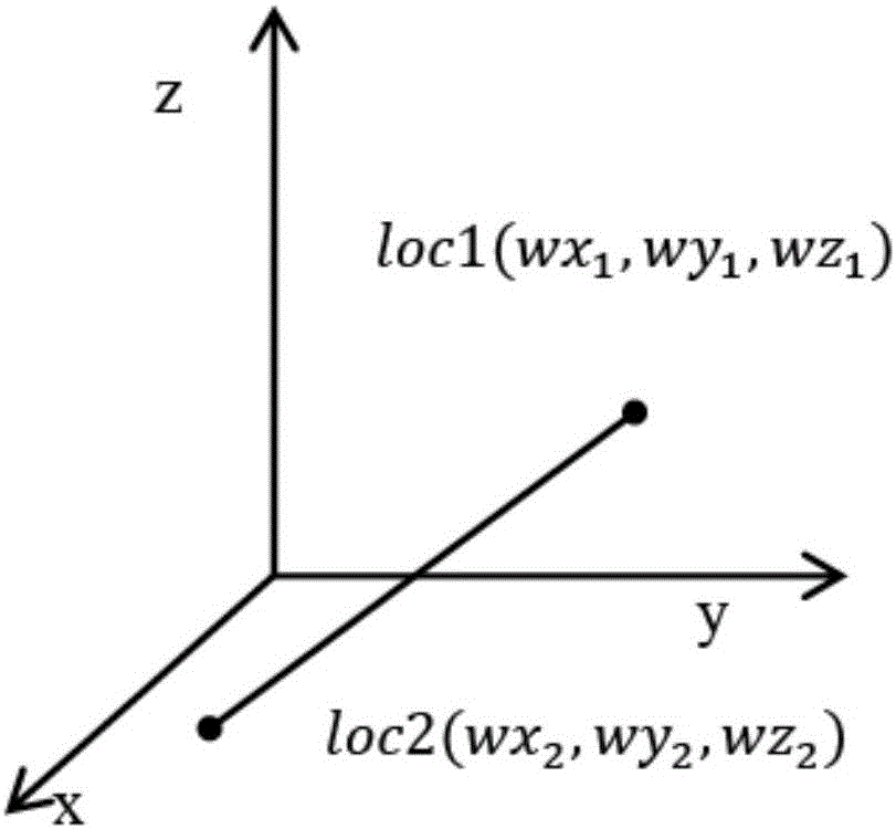
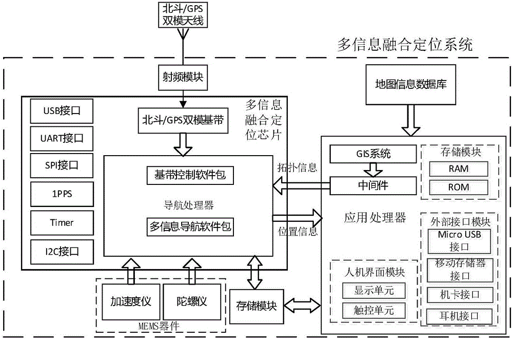

Image

  • Positioning method and device based on pseudorange and linear vector
  • Positioning method and device based on pseudorange and linear vector
  • Positioning method and device based on pseudorange and linear vector

Examples


Embodiment Construction

[0031] The technical solutions of the present invention will be further elaborated below in conjunction with the accompanying drawings and specific embodiments.

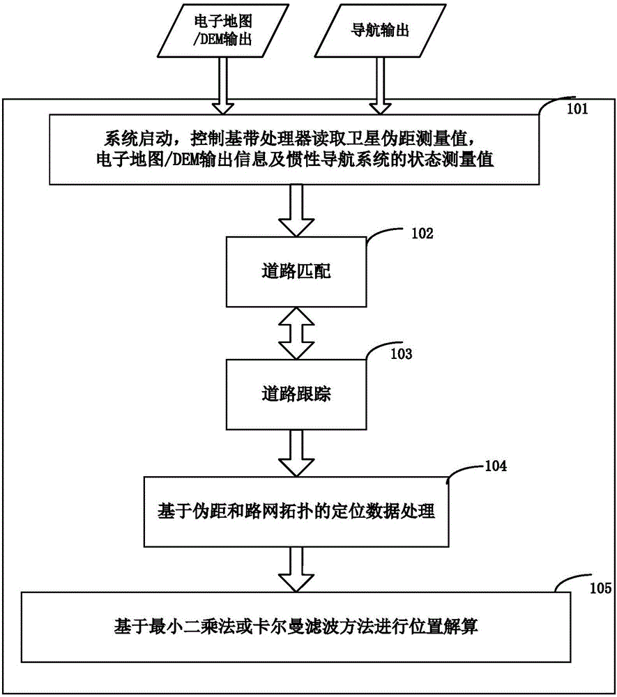
[0032] figure 2 It is a schematic flow chart of the positioning method based on pseudorange and linear vector in the present invention, such as figure 2 As shown, the method includes the following steps:

[0033] Step 101, satellite data and map data are read. Specifically:

[0034] system boot,

[0035] The satellite processing module receives satellite signals and sends an interrupt to the processor after the tracking channel is ready for measurement. The processor reads measurement values ​​from the tracking channel, and the measurement values ​​include: code measurement values ​​and carrier measurement values. Read map data; select positioning methods according to the number of satellites and user settings, including satellite positioning and fusion positioning. If fusion positioning is selected, perform ...


PUM


Abstract

The invention discloses a positioning method based on pseudo-ranges and linear vectors. The method includes: based on the road currently operated by the carrier, reading the topological structure, direction vector, road length, Data such as electronic elevation. Obtain the pseudo-range information of the satellite through the satellite navigation unit; extract the linear vector constraint equation of the current road in the ECEF coordinate system according to the topological information of the carrier's operating road; form the distance equation between two points in space according to the satellite pseudo-range; use the least square method Or the Kalman filter algorithm for position calculation. The present invention also provides a device for realizing the above method, which can effectively solve the positioning problem in the environment where satellite signals are blocked, and expand the positioning coverage of satellite navigation.

Description

technical field [0001] The invention relates to the technical field of satellite positioning and inertial navigation, in particular to a positioning method and device based on satellite pseudo-range, road network data and elevation data. Background technique [0002] With the development of my country's economy and the acceleration of urbanization, motor vehicles have become an indispensable means of transportation in people's daily life, and the growth rate of vehicles is far greater than the growth rate of road mileage. The number of operating vehicles represented by dangerous goods transportation and logistics is increasing year by year. [0003] With the sharp increase in the number of vehicles, urban traffic problems are becoming more and more serious, resulting in a series of urban diseases such as road congestion, frequent traffic accidents, and serious traffic pollution, which have become a major bottleneck restricting economic development and building a harmonious s...

Claims


Application Information

Patent Timeline
IPC IPC(8): G01C21/28G01S19/45
CPCG01C21/28G01S19/45
Inventor 路卫军原媛
Owner BEIJING UNIV OF POSTS & TELECOMM
Learn More