GNSS high precision assisted unmanned plane aerotriangulation method

A measurement method and UAV technology, which can be used in measurement devices, photogrammetry/video measurement, surveying and navigation, etc., and can solve the problems of unclear sensor function and unclear system composition description.

Inactive Publication Date: 2016-08-03
李德仁
View PDF4 Cites 10 Cited by
  • Summary
  • Abstract
  • Description
  • Claims
  • Application Information

AI Technical Summary

Problems solved by technology

However, there are the following deficiencies in this scheme: 1) The description of the composition of the

Method used


Image

  • GNSS high precision assisted unmanned plane aerotriangulation method
  • GNSS high precision assisted unmanned plane aerotriangulation method
  • GNSS high precision assisted unmanned plane aerotriangulation method

Examples


Embodiment 1

[0036] In the embodiment of the present invention, using GNSS to obtain high-precision position information is a key step in reducing ground control points in UAV photogrammetry.

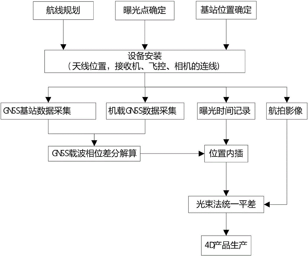
[0037] see Figure 1~6 , a GNSS high-precision assisted UAV aerial three-dimensional measurement method, the specific steps are as follows:

[0038] 1) According to the area, shape, position and other conditions of the area to be surveyed and mapped, draw the flight route map, exposure point position and other parameters in the ground control system software of the UAV. Two frame headings are arranged at both ends, and the flight height is generally 15% higher than the height of the route, and a suitable GNSS base station location is selected in the survey area;

[0039] 2) Install the high-precision GNSS differential receiver antenna directly above the camera as much as possible to reduce the distance between the GNSS solution position and the actual required position of the principal point, and u...


PUM


Abstract

The invention discloses a GNSS high-precision assisted unmanned aerial vehicle three-dimensional measurement method, which uses an airborne GNSS receiver, a GNSS base station receiver, and a camera for synchronous observation, including: the airborne GNSS receiver accurately records the exposure time of the camera, and uses a carrier After the phase difference is decomposed and calculated, the centimeter-level position information of the antenna is obtained, and then the outer bearing line element at the exposure time of the camera is obtained by interpolation, which is used as the starting data. Combined with a small number of ground control points, the aerial triangulation software is used for automatic processing, and each image is obtained. The outer orientation elements of the film, and then produce the required 4D image. The present invention adopts the method of differential positioning, and uses the GNSS differential position information corrected by the eccentricity to replace the position information of the exposure point, so as to obtain the line elements in the outer orientation elements required in aerial photogrammetry, which greatly improves the accuracy of the UAV. The efficiency of low-altitude photogrammetry reduces field workload.

Description

technical field [0001] The invention relates to the field of low-altitude photogrammetry, in particular to a GNSS high-precision assisted UAV aerial three-dimensional measurement method. Background technique [0002] Traditional aerial photogrammetry is mostly used to solve small-scale mapping of large areas. For the problem of large-scale mapping of small areas that has emerged in the field of measurement in recent years, if conventional aerial photography is still used, it often results in high cost and poor flexibility. , are greatly affected by the weather, etc., so low-altitude triangulation technology based on low-altitude unmanned aerial vehicles and conventional digital cameras has become a hot issue in the field of photogrammetry in recent years. Usually, the data acquisition devices used are generally low-altitude photography platforms (UAVs, unmanned airships, etc.) and ordinary multi-lens integrated small data cameras (Canon 5D_Mark II). It is easily affected by...

Claims


Application Information

Patent Timeline
IPC IPC(8): G01C11/00
CPCG01C11/00
Inventor 孙红星李德仁丁学文王晖范明灿
Owner 李德仁
Why Eureka
Try Eureka