A Method of Interferometric SAR Data Imaging and Elevation Estimation

A data and imaging technology, applied in the field of radar and synthetic aperture radar imaging, which can solve the problems of high-precision elevation estimation, geometric correction, and separation of imaging and elevation estimation in difficult-to-interfere SAR.

Inactive Publication Date: 2018-02-13
UNIV OF ELECTRONICS SCI & TECH OF CHINA
View PDF4 Cites 0 Cited by
  • Summary
  • Abstract
  • Description
  • Claims
  • Application Information

AI Technical Summary

Problems solved by technology

However, in the process of interferometric SAR imaging data processing, the current back-projection imaging algorithm only realizes partial synchronous processing of interferometric SAR echo data imaging and interferometric phase extraction, and its data imaging process and elevation estimation process are still independent of each other, so There are still problems with the separation of imaging and elevation estimation in traditional interferometric SAR data processing, and it is difficult to perform interferometric SAR high-precision elevation estimation, geometric correction, etc.

Method used


Image

  • A Method of Interferometric SAR Data Imaging and Elevation Estimation
  • A Method of Interferometric SAR Data Imaging and Elevation Estimation
  • A Method of Interferometric SAR Data Imaging and Elevation Estimation

Examples


Embodiment Construction

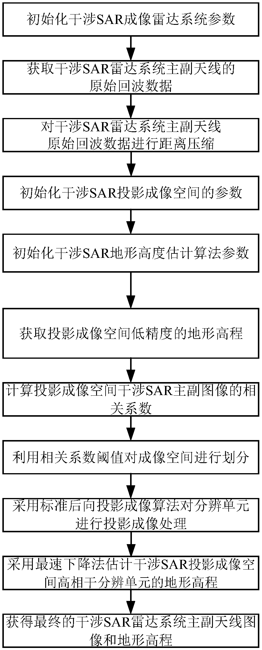
[0070] The present invention mainly adopts the method of simulation experiment to verify, and all steps and conclusions are verified correctly on MATLABR2014b software. The specific implementation steps are as follows:

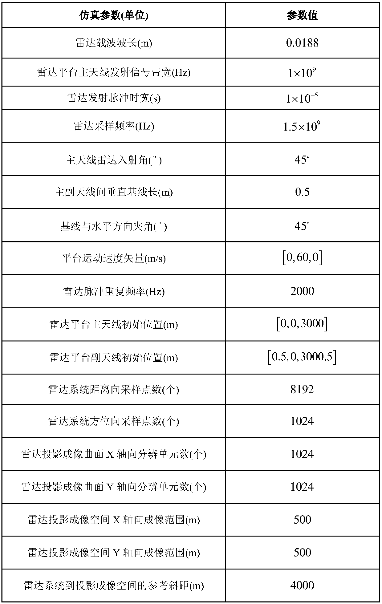
[0071] Step 1. Initialize the parameters of the interferometric SAR imaging radar system:

[0072] Initialize the parameters of the interferometric SAR imaging radar system, including: the signal carrier wavelength λ=0.0188m for the radar system to work, the bandwidth of the signal transmitted by the main antenna of the radar platform B=1×10 9 Hz, radar transmit pulse width T r =1×10 -5 s, the sampling frequency F of the radar platform receiving system s =1.5×10 9 Hz, main antenna radar incidence angle θ=45°, vertical baseline length B between main and auxiliary antennas ⊥ = 0.5m, the angle between the baseline and the horizontal direction α = 45°, the radar pulse repetition frequency PRF = 2000Hz, the platform motion velocity vector V r =[0,60,0]m / s, th...


PUM


Abstract

The invention discloses an interferometric SAR data imaging and elevation estimation method, which is based on the back projection imaging theory, utilizes the corresponding relationship between the interferometric phase and the terrain elevation during the imaging process of the interferometric SAR back projection algorithm, and uses the imaging space terrain elevation The principle of the minimum interferometric phase obtained when the real terrain elevation is obtained, the terrain elevation corresponding to the minimum interferometric phase is found by the steepest descent method, and finally the interferometric SAR data is projected to the best imaging space terrain elevation estimated by the steepest descent method for imaging, so that The synchronous processing of interferometric SAR echo data imaging and elevation estimation is realized. Compared with the prior art, the invention reduces the distortion effect of the interferometric SAR image caused by the terrain elevation fluctuation, and improves the image quality of the interference SAR imaging and the estimation accuracy of the terrain elevation under the condition of the terrain elevation fluctuation.

Description

technical field [0001] The invention belongs to the field of radar technology, in particular to the field of synthetic aperture radar (SAR) imaging technology. Background technique [0002] Interferometric Synthetic Aperture Radar (Interferometric SAR) is an extension of Synthetic Aperture Radar (SAR) imaging technology, which mainly uses two or more SAR images obtained by observing the same observation scene at different angles or at different time periods by using more than two antennas or multiple voyages. , extract the SAR image interferometric phase information, and then combine the imaging geometric relationship to invert the terrain elevation information, so as to realize the remote sensing technology of high-precision terrain three-dimensional mapping. Interferometric SAR has the advantages of large imaging area, high imaging accuracy, and all-weather and all-time imaging. It has become an important remote sensing technology for extracting large-area surface three-di...

Claims


Application Information

Patent Timeline
Patent Type & Authority Patents(China)
IPC IPC(8): G01S13/90
CPCG01S13/9023G01S13/9017
Inventor 韦顺军张晓玲段亚楠余鹏
Owner UNIV OF ELECTRONICS SCI & TECH OF CHINA
Why Eureka
Try Eureka