Navigation apparatus and method for surface inspection of spacecraft

A technology for a navigation device and a spacecraft, which is applied in the field of aerospace on-orbit services, can solve the problems of restricting the available orbit of a micro-extravehicular robot camera and cannot be used, and achieves the effect of low cost and reduced dependence.

Inactive Publication Date: 2016-09-21
NANJING UNIV OF AERONAUTICS & ASTRONAUTICS
View PDF6 Cites 12 Cited by
  • Summary
  • Abstract
  • Description
  • Claims
  • Application Information

AI Technical Summary

Problems solved by technology

However, in the process of differential GPS positioning, due to factors such as multipath reflection, the positioning accuracy can only be guaranteed at the meter level, and this positioning method cannot be used on orbits such as GEO without GPS signal coverage, which limits the miniature extravehicular robot. available tracks for the camera

Method used


Image

  • Navigation apparatus and method for surface inspection of spacecraft
  • Navigation apparatus and method for surface inspection of spacecraft
  • Navigation apparatus and method for surface inspection of spacecraft

Examples


Embodiment Construction

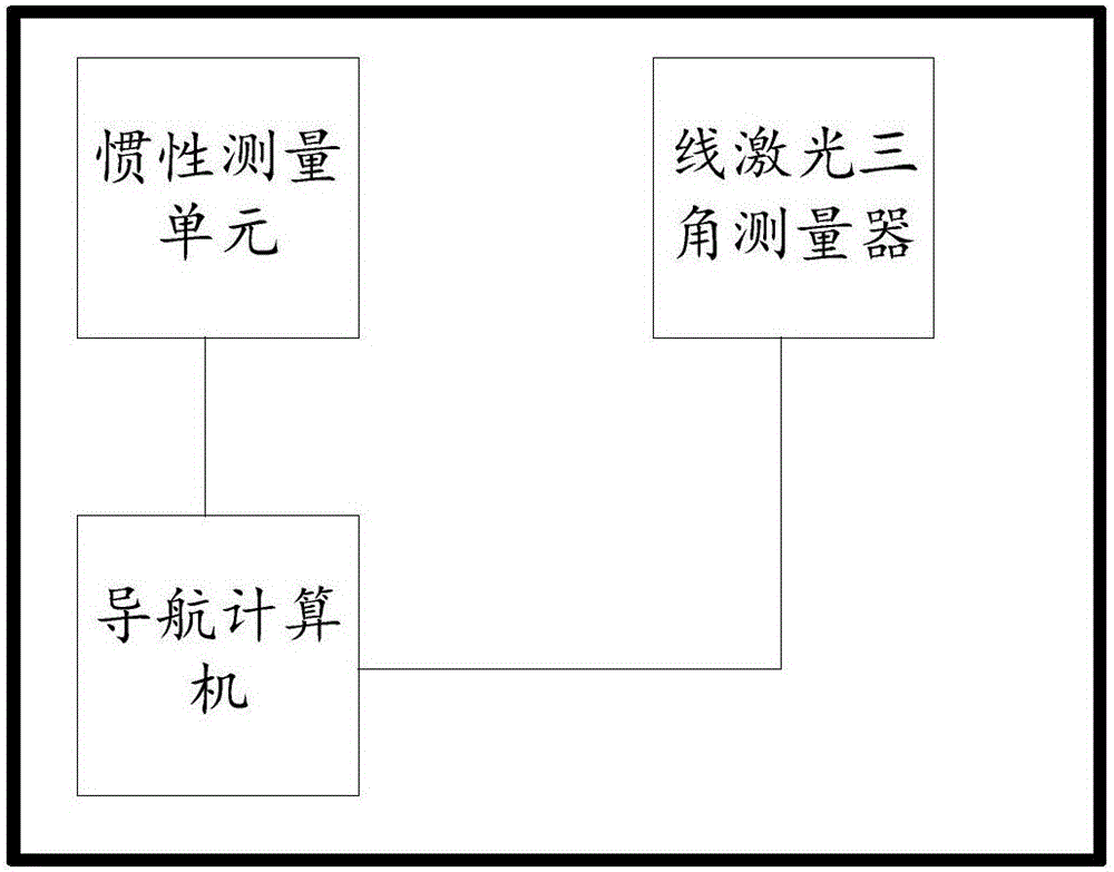
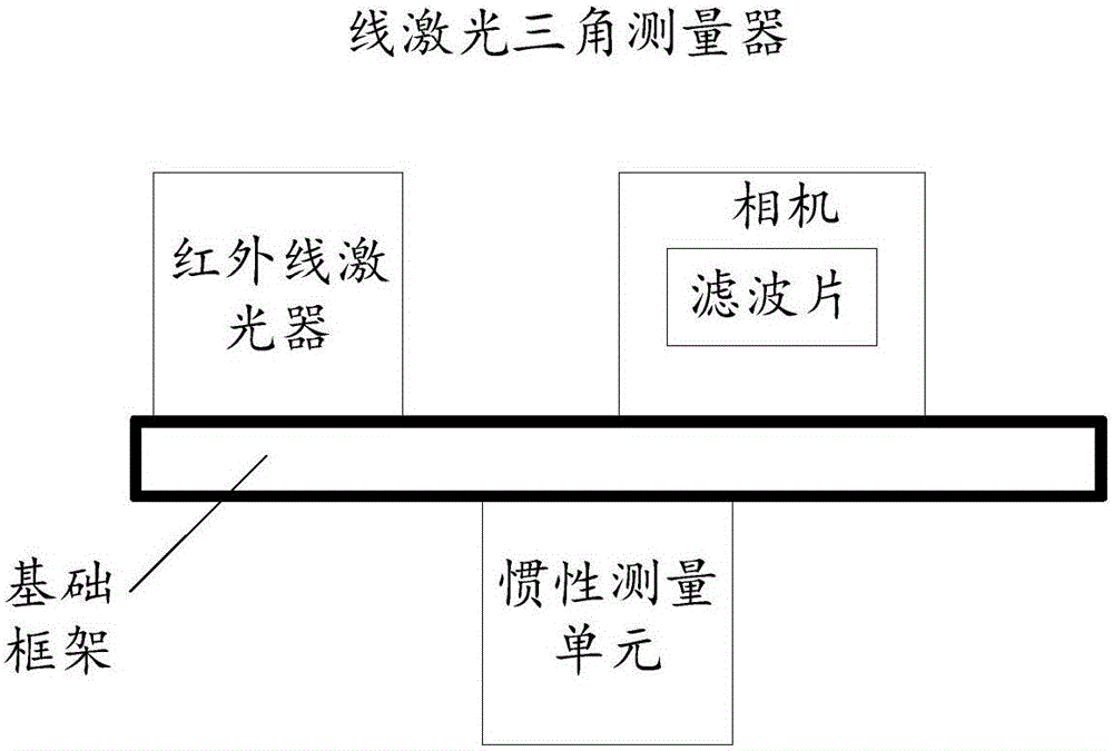
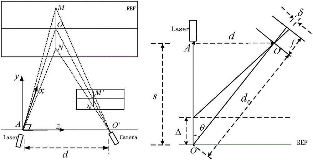
[0023] In order to enable those skilled in the art to better understand the technical solutions of the present invention, the present invention will be further described in detail below in conjunction with the accompanying drawings and specific embodiments. Hereinafter, embodiments of the present invention will be described in detail, examples of which are shown in the accompanying drawings, wherein the same or similar reference numerals denote the same or similar elements or elements having the same or similar functions throughout. The embodiments described below by referring to the figures are exemplary only for explaining the present invention and should not be construed as limiting the present invention. Those skilled in the art will understand that unless otherwise stated, the singular forms "a", "an", "said" and "the" used herein may also include plural forms. It should be further understood that the word "comprising" used in the description of the present invention refe...


PUM


Abstract

The embodiments of the invention disclose a navigation apparatus and a method for the surface inspection of a spacecraft and relates to the technical field of the aerospace on-orbit-servicing technology, wherein the relative navigation of an inspection device and the surface structure detection of a target spacecraft are multiplexed. According to the invention, the orbital coordinate system of the target spacecraft is adopted as a navigation coordinate system. The acceleration and angular velocity information outputted by an inertial measurement unit is adopted for the pure inertial navigation integral calculation, so that the navigation parameters of the target spacecraft relative to the navigation coordinate system, including the attitude, the position, the speed and the like, are calculated. Moreover, the point cloud data of the profile of the spacecraft are measured based on the triangle method. The obtained point cloud data of the profile of the spacecraft are converted to be data in a geodetic coordinate system based on the short-time and high-accuracy features of the inertial navigation and the installation parameters of a linear laser triangulation survey meter. In addition, the known structural data of the profile of the target spacecraft is rectified according to the actually measured point cloud data of the profile of the spacecraft, so that the attitude and the position of the inspection device relative to the navigation coordinate system are calculated. Meanwhile, the attitude and the position, measured by a Kalman filter, are integrated with the navigation information calculated by the inertial navigation system. As a result, accurate navigation parameters can be obtained.

Description

technical field [0001] The invention relates to the field of aerospace on-orbit service technology, in particular to a navigation device and method for patrolling the surface of a spacecraft. Background technique [0002] With the development of aerospace technology, there are more and more large spacecraft in orbit, such as space stations and large satellites. Due to the long operating time of large spacecraft in orbit, they are vulnerable to damage caused by impacts from space objects such as micrometeoroids. In order to reduce the operational risk of large spacecraft, it is necessary to quickly and timely discover the abnormality of the external surface of large spacecraft and perform maintenance. [0003] At present, the outer shell maintenance inspection of large spacecraft is mainly through the miniature extravehicular robot camera, which uses nitrogen propulsion as power to move on the surface of the spacecraft, so as to help astronauts and ground staff observe the sp...

Claims


Application Information

Patent Timeline
Patent Type & Authority Applications(China)
IPC IPC(8): G01C21/16
CPCG01C21/165
Inventor 郁丰王振宇何真赵依华冰吴云华陈志明
Owner NANJING UNIV OF AERONAUTICS & ASTRONAUTICS
Why Eureka
Try Eureka