A rock weathering degree extracting method based on the satellite remote sensing technology

A weathering degree and satellite remote sensing technology, applied in the field of remote sensing geology, can solve the problems of difficult weathering, large time consumption, manpower, material resources, and financial resources, and achieve the effect of large-scale information acquisition and rapid extraction

Inactive Publication Date: 2016-10-19
中国人民解放军沈阳军区司令部工程科研设计所
View PDF2 Cites 2 Cited by
  • Summary
  • Abstract
  • Description
  • Claims
  • Application Information

AI Technical Summary

Problems solved by technology

[0007] (1) Using the ground method to study the degree of weathering requires a huge amount of manpower, material resources, and financial resources, and its work efficiency is also very low, which is difficult to meet the needs of research on the degree of weathering in the context of massive data; in addition, for many geologically complex areas, especially high vegetation coverage area, which is difficult to study using ground-based methods to study the degree of weathering
[0008] (2) There are mainly the following problems in using the spectral characteristics of rocks to study the degree of weathering: ① areas with large vegetati

Method used


Image

  • A rock weathering degree extracting method based on the satellite remote sensing technology
  • A rock weathering degree extracting method based on the satellite remote sensing technology

Examples


Embodiment Construction

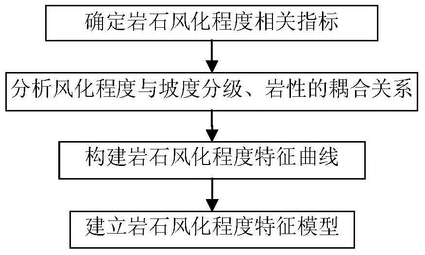
[0025] A method for extracting rock weathering degree based on satellite remote sensing technology of the present invention will be described in detail below in conjunction with the accompanying drawings and embodiments.

[0026] A method for extracting rock weathering degree based on satellite remote sensing technology of the present invention comprises the following steps:

[0027] Step 1. Determine the relevant indicators of rock weathering degree

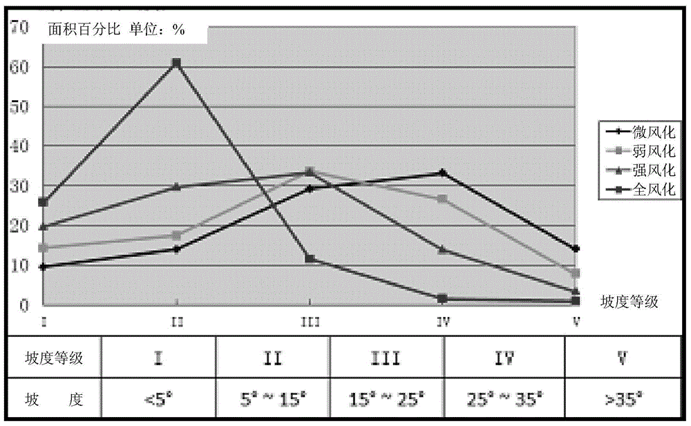
[0028] Select a typical test area for field survey and test, analyze the relationship between the degree of rock weathering and geological environmental factors on the basis of existing research, and determine the indicators such as stratum lithology and slope that have a strong indicator effect on the degree of rock weathering as candidates Since remote sensing technology is quite mature in lithology identification and slope extraction, the determination of formation lithology and slope is a relevant index for establishing a ro...


PUM


Abstract

The invention belongs to the technical field of remote sensing geology and in particular relates to a rock weathering degree extracting method based on the satellite remote sensing technology. The method comprises the steps of determining the indexes of correlation of the rock weathering degree; analyzing the coupling relationship between the rock weathering degree and the formation lithology and slope grade; establishing a rock weathering degree characteristic curve; building a rock weathering degree characteristic model. The method solves the technical problems that conventional methods cannot extract the rock weathering degree accurately and rapidly, exploits the advantages of rapid and large-area information acquisition of remote sensing, can extract the rock weathering degree accurately and rapidly and can be applied to rock weathering degree division of mass data.

Description

technical field [0001] The invention belongs to the technical field of remote sensing geology, and in particular relates to a method for extracting rock weathering degree based on satellite remote sensing technology. Background technique [0002] Rock weathering refers to the synthesis of various effects that change the mineral composition, structural state, and physical and mechanical properties of rocks. It mainly includes various factors such as the sun, the atmosphere, water, and organisms. [0003] Weathering is one of the important factors that affect the nature of rock engineering. Accurately classifying the weathering degree of rock is an important content to provide safe design parameters for engineering design. The division of rock weathering degree and the study of engineering characteristics play a key role in the selection of large-scale hydropower projects, high-rise buildings, roads and bridges and other engineering building bases and the determination of foun...

Claims


Application Information

Patent Timeline
IPC IPC(8): G06F19/00
Inventor 于德浩龙凡李霞杨清雷王康韩天成张宣宣李秀坤张连伟张垚李航陈思扬
Owner 中国人民解放军沈阳军区司令部工程科研设计所
Why Eureka
Try Eureka