Integrated data-driven and model-driven airborne lidar data modeling method

A comprehensive data, model-driven technology, applied in the field of remote sensing science, can solve problems such as difficult to guarantee the regularity of the geometric appearance of the model, unsuitable for modeling, high time complexity of roof structural elements, etc.

Active Publication Date: 2018-11-16
NANJING FORESTRY UNIV
View PDF5 Cites 0 Cited by
  • Summary
  • Abstract
  • Description
  • Claims
  • Application Information

AI Technical Summary

Problems solved by technology

[0012] (1) Although the simplified modeling method using digital surface models is more suitable for dealing with complex free-form buildings and generating LOD (Level of Detail, LOD) models of different scales, which is convenient for network transmission and visual rendering, the ALS data Integrity and noise are more sensitive, and it is difficult to guarantee the regularity of the geometric appearance of the model. In addition, there is no unified standard for how to simplify the model. In addition, this method has high time complexity and is not suitable for large-scale urban buildings. modeling;
[0013] (2) Reverse semantic process modeling is convenient for editing the structure of the building model (the number of floors, the number of windows in each floor, etc.), but there is no unified model for the compilation of semantic rules, and corresponding semantic rules need to be defined for different building structures, and The optimization link has high time complexity and is not suitable for reconstruction of large-area buildings;
[0014] (3) The data-driven modeling method does not need to assume the roof structure type of the building in advance. In theory, any roof type can be modeled, but the segmentation of roof structure elements often has a high time complexity, and even requires the help of human-computer interaction In addition, this type of method is also sensitive to the noise, density, uniformity and integrity of the ALS data, and the quality of the data seriously affects the accuracy of the final model;
[0015] (4) The model-driven modeling method is not sensitive to the quality of ALS data, and the constructed model has the characteristics of compactness, lightness (consisting of fewer triangles) and seamlessness, but it is only suitable for parameterization To express simple buildings, even with the help of "CSG" modeling ideas to deal with complex structural buildings, the primitive library of the limited parameter model library is difficult to completely match the changing buildings in the real world

Method used


Image

  • Integrated data-driven and model-driven airborne lidar data modeling method

Examples


Embodiment Construction

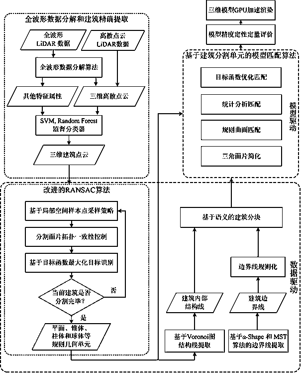
[0028] With reference to the accompanying drawings, the integrated data-driven and model-driven airborne LiDAR data modeling method includes the following steps:

[0029] (1) Accurate decomposition of full waveform LiDAR data waveform and building extraction;

[0030] (2) Data-driven roof segmentation of complex buildings;

[0031] (3) Semantic division of building roofs;

[0032] (4) Building roof modeling based on segmented units;

[0033] (5) Accuracy evaluation and rendering of architectural models.

[0034] The precise waveform decomposition and building extraction of the full-waveform LiDAR data, the specific method is: for the airborne full-waveform LiDAR data obtained by the Riegl LMS-Q560 device, it needs to be decomposed into a three-dimensional discrete point cloud, and the objective function is as follows:

[0035] (1)

[0036] in, x i Indicates the first in the backscattering waveform i time sampling points, the corresponding echo intensity value is y ...


PUM


Abstract

The invention provides an airborne LiDAR (Light Detection And Ranging) data modeling method driven by integrated data and a model. The method comprises the following steps of: (1) full-waveform LiDAR data waveform precise decomposition and building extraction, (2) complex building roof segmentation based on data driving, (3) building roof semantic division, (4) building roof modeling based on segmentation units and (5) building model precision evaluation and rendering. The method of the invention has the advantages that the complex building roof can be precisely and reasonably segmented, the topological relationship between roof segmented facets can be maintained, the structure and the boundary line of the complex building roof and a large-area connected building can be extracted in a detailed mode, and conditions are created for reasonable building semantics blocking; and a complex building model can be built, the model rationality and a high rebuilding efficiency can be ensured, and the method can be widely applied to city modeling in a large-scale scene.

Description

technical field [0001] The invention proposes a comprehensive data-driven and model-driven airborne LiDAR data modeling method, which belongs to the field of remote sensing science and technology. Background technique [0002] With the development and application of spatial information technology, people's demand for data is getting higher and higher. Traditional two-dimensional data can no longer fully meet the needs of daily life and production. With 3S technology, high-performance computing and three-dimensional visualization With the development of technology, it is completely possible to efficiently acquire and process massive two-dimensional or three-dimensional data, such as Google Earth developed by Google and Bing Maps service launched by Microsoft, which allows people to roam in a virtual world composed of three-dimensional models , to experience the immersive artistic conception, the rich spatial information of 3D data helps to express the objective world more rea...

Claims


Application Information

Patent Timeline
Patent Type & Authority Patents(China)
IPC IPC(8): G06T17/30G06T15/04
CPCG06T15/04G06T17/30
Inventor 陈动杜建丽郑加柱史玉峰史晓云杨强王增利
Owner NANJING FORESTRY UNIV
Why Eureka
Try Eureka