Walking track data calculating method an device

A data and track technology, applied in the field of navigation and positioning, can solve the problems of poor accuracy and precision of dead reckoning

Active Publication Date: 2016-11-30
BEIJING FINE WAY TECH CO LTD
View PDF9 Cites 17 Cited by
  • Summary
  • Abstract
  • Description
  • Claims
  • Application Information

AI Technical Summary

Problems solved by technology

[0007] Aiming at the defects in the prior art, the present invention provides a method and device for calculating pedestrian track data, so as to solve the problem that t

Method used


Image

  • Walking track data calculating method an device
  • Walking track data calculating method an device
  • Walking track data calculating method an device

Examples


Embodiment Construction

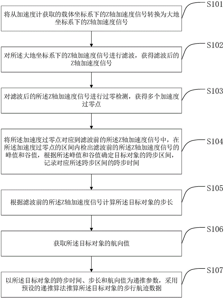
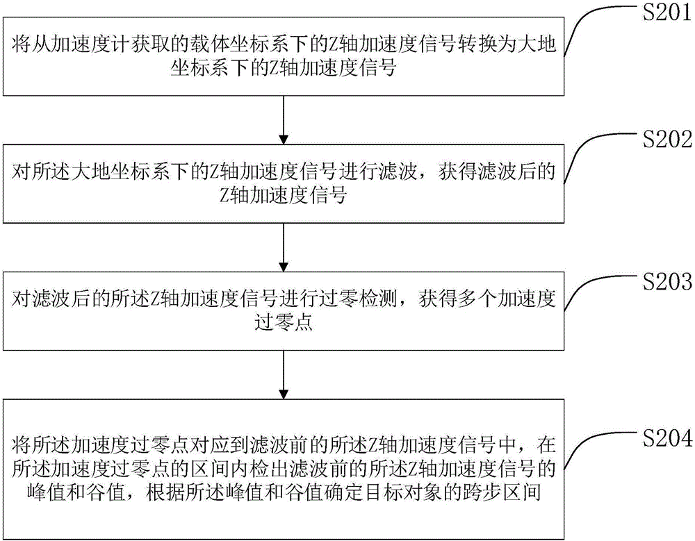
[0137] Embodiments of the technical solutions of the present invention will be described in detail below in conjunction with the accompanying drawings. The following examples are only used to illustrate the technical solution of the present invention more clearly, so they are only examples, and should not be used to limit the protection scope of the present invention.

[0138] It should be noted that, unless otherwise specified, the technical terms or scientific terms used in this application shall have the usual meanings understood by those skilled in the art to which the present invention belongs.

[0139] figure 1 A flow chart of a method for deriving walking track data provided by the first embodiment of the present invention is shown. Such as figure 1 As shown, a method for calculating walking track data provided by the first embodiment of the present invention includes the following steps:

[0140] Step S101: Convert the Z-axis acceleration signal in the carrier coord...


PUM


Abstract

The invention provides a walking track data calculating method which includes the steps: firstly, converting Z-axis acceleration signals acquired from an acceleration meter into Z-axis acceleration signals under a geodetic coordinate system; secondly, filtering the Z-axis acceleration signals; thirdly, performing zero-cross detection for the filtered Z-axis acceleration signals to obtain a plurality of acceleration zero-cross points; fourthly, enabling the acceleration zero-cross points to correspond to the Z-axis acceleration signals before filtration, detecting peak values and valley values of the Z-axis acceleration signals before filtration in intervals of the acceleration zero-cross points, determining step through intervals of a target object according to the peak values and the valley values, and recording corresponding step through time; fifthly, calculating the step length of the target object according to the Z-axis acceleration signals before filtration; finally, taking the step through time of the target object, the step length and track values as recursive parameters, and calculating walking track data of the target object by a preset recursive algorithm. By the method, calculating accuracy and precision of the walking track data can be effectively improved.

Description

technical field [0001] The invention relates to the technical field of navigation and positioning, in particular to a method and device for calculating pedestrian track data, and a method and device for judging the stride interval of pedestrian track. Background technique [0002] GNSS (Global Navigation Satellite System), such as Beidou (BEIDOU), GPS, etc., are more and more known by people. In outdoor open areas, its positioning accuracy is usually better than 5 meters, which has met the needs of ordinary life and production. However, in indoor, underground, and densely built areas, GNSS signals are usually weak, lost, and multipath effects are generated. These factors will cause GNSS positioning to be inaccurate or even impossible to locate. [0003] INS (InertialNavigationSystem, inertial navigation system) is mainly composed of IMU (InertialMeasurementUnit, inertial measurement unit), usually including the following modules: three-axis gyroscope, three-axis acceleromet...

Claims


Application Information

Patent Timeline
IPC IPC(8): G01C21/20
Inventor 吕明张弛王子亮徐枫
Owner BEIJING FINE WAY TECH CO LTD
Why Eureka
Try Eureka