Method and apparatus for route planning
A route planning and route technology, applied in the field of maps, can solve problems such as reducing user experience, reducing the accuracy of route planning, and tedious process of adding waypoints, achieving the effects of easy interaction, improved accuracy, and improved interaction methods.
- Summary
- Abstract
- Description
- Claims
- Application Information
AI Technical Summary
Problems solved by technology
Method used
Image

Examples
Embodiment 1
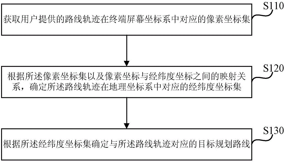
[0025] figure 1 It is a flow chart of a route planning method provided by Embodiment 1 of the present invention. This embodiment is applicable to the situation of planning a passing route according to user wishes, and the method can be executed by a route planning device. The device can be realized by means of hardware and / or software, and can generally be integrated into a server that provides route navigation services for electronic map products.
[0026] Generally, the electronic map navigation application may first receive a route planning request triggered by the user through human-computer interaction, and the request includes the starting point and the ending point of the route that the user wants to pass. When the route planned for the first time based on the route planning request does not conform to the expected route, the user’s self-planning mode for the passing route can be started. Therefore, a method of route planning provided by the implementation of the presen...
Embodiment 2
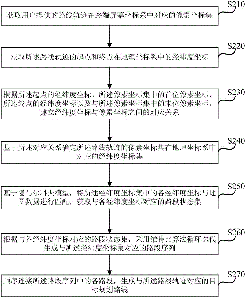
[0040] figure 2 It is a flow chart of a route planning method provided by Embodiment 2 of the present invention. This embodiment is optimized on the basis of the above-mentioned embodiments. In this embodiment, according to the pixel coordinate set, pixel coordinates and latitude and longitude coordinates The mapping relationship between them determines the latitude and longitude coordinate set corresponding to the route trajectory in the geographic coordinate system, and is specifically optimized as: obtaining the latitude and longitude coordinates of the starting point and the end point of the route trajectory in the geographic coordinate system; according to the latitude and longitude coordinates of the starting point coordinates, the first pixel coordinates in the pixel coordinate set, the latitude and longitude coordinates of the end point, and the last pixel coordinates in the pixel coordinate set, establish the correspondence between the latitude and longitude coordinat...
Embodiment 3
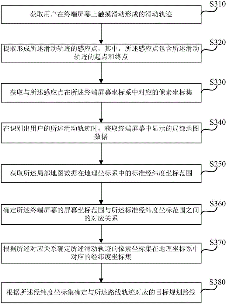
[0062] Fig. 3 is a flow chart of a method for route planning provided by Embodiment 3 of the present invention. This embodiment is optimized on the basis of the above-mentioned embodiments. In this embodiment, the coordinates of the route trajectory provided by the user will be acquired The corresponding pixel coordinate set in the system is specifically optimized as follows: obtaining the sliding track formed by the user touching and sliding on the terminal screen; extracting the sensing point forming the sliding track, wherein the sensing point includes the starting point and the ending point of the sliding track ; Obtain a pixel coordinate set corresponding to the sensing point in the terminal screen coordinate system.
[0063] On the basis of the above optimization, according to the pixel coordinate set and the mapping relationship between the pixel coordinates and the latitude and longitude coordinates, determine the latitude and longitude coordinate set corresponding to t...
PUM
 Abstract
Description
Claims
Application Information
 - R&D
- Intellectual Property
- Life Sciences
- Materials
- Tech Scout
- Unparalleled Data Quality
- Higher Quality Content
- 60% Fewer Hallucinations
Browse by: Latest US Patents, China's latest patents, Technical Efficacy Thesaurus, Application Domain, Technology Topic, Popular Technical Reports.
© 2025 PatSnap. All rights reserved.Legal|Privacy policy|Modern Slavery Act Transparency Statement|Sitemap|About US| Contact US: help@patsnap.com