Unmanned aerial vehicle tracking system and method based on differential satellite navigation

An unmanned aerial vehicle and satellite navigation technology, applied in the field of unmanned aerial vehicle following systems, can solve the problem of inability to complete the high-precision following of the aircraft, and achieve the effect of improving accuracy

Active Publication Date: 2016-12-07
BEIJING DAGONG TECH CO LTD
View PDF5 Cites 13 Cited by
  • Summary
  • Abstract
  • Description
  • Claims
  • Application Information

AI Technical Summary

Problems solved by technology

Due to the large error of ordinary satellite navigation, the error in the horizontal direction is 3-5 meters, and the error in

Method used


Image

  • Unmanned aerial vehicle tracking system and method based on differential satellite navigation
  • Unmanned aerial vehicle tracking system and method based on differential satellite navigation
  • Unmanned aerial vehicle tracking system and method based on differential satellite navigation

Examples


Embodiment Construction

[0019] The present invention will be further described in detail below in conjunction with the accompanying drawings and embodiments. It should be understood that the specific embodiments described here are only used to explain the present invention, but not to limit the present invention. In addition, it should be noted that, for the convenience of description, only some structures related to the present invention are shown in the drawings but not all structures.

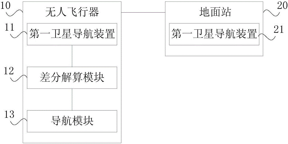
[0020] figure 1 It is a schematic structural diagram of the UAV tracking system based on differential satellite navigation provided in the specific embodiment of the present invention. like figure 1 As shown, the UAV tracking system mainly includes:

[0021] The first satellite navigation device 11, the second satellite navigation device 21, the difference resolution module 12 and the navigation module 13;

[0022] The first satellite navigation device 11 is arranged on the ground station 20 of the UAV 10 and r...


PUM


Abstract

The invention discloses an unmanned aerial vehicle tracking system and method based on differential satellite navigation. The system comprises a first satellite navigation device, a second satellite navigation device, a differential resolving module and a navigation module. The first satellite navigation device is arranged on the ground station of an unmanned aerial vehicle and receives first satellite positioning data. The second satellite navigation device is arranged on the unmanned aerial vehicle and receives second satellite positioning data. The differential resolving module resolves the position of the unmanned aerial vehicle relative to the ground station according to the first satellite positioning data and the second satellite positioning data. The navigation module controls the unmanned aerial vehicle to be directly above the ground station according to the position of the unmanned aerial vehicle relative to the ground station in a proportional-integral-differential PID control manner. According to the invention, the accuracy of mooring tracking of the unmanned aerial vehicle is improved, and accurate relative distance and azimuth of centimeter level are acquired.

Description

technical field [0001] Embodiments of the present invention relate to the field of unmanned aerial vehicles, and in particular to an unmanned aerial vehicle tracking system and method based on differential satellite navigation. Background technique [0002] Tethered drones, because they can provide long-term airborne capabilities, have been widely valued and adopted in the fields of situation monitoring, signal relay, and forest firefighting. [0003] Tethered UAVs are more difficult to land because of the existence of tethered cables. At the same time, users put forward higher requirements for their fixed-point landing on the tethered platform during use. If the operator manually implements the landing of the unmanned aerial vehicle and the following of the vehicle, there are problems such as poor precision and difficult operation, and it is often impossible to complete in a real environment. If automatic fixed-point landing can be realized, it will greatly reduce the diff...

Claims


Application Information

Patent Timeline
IPC IPC(8): G05D1/08G05D1/10G01S19/51
CPCG01S19/51G05D1/0808G05D1/101
Inventor 余志勇卢增祥王飞王康
Owner BEIJING DAGONG TECH CO LTD
Why Eureka
Try Eureka