Mountain fire monitoring and positioning method based on small-sized radar

A technology of small radar and positioning method, which is applied to fire alarms that act by electricity and fire alarms that rely on radiation. Good operability and practicability, reasonable conception, and solving the effect of low spatial resolution

Active Publication Date: 2016-12-14
WUHAN NARI LIABILITY OF STATE GRID ELECTRIC POWER RES INST +3
View PDF5 Cites 8 Cited by
  • Summary
  • Abstract
  • Description
  • Claims
  • Application Information

AI Technical Summary

Problems solved by technology

Its main shortcoming is that the mountain fire monitoring satellite is affected by the transit time and cannot realize real-time monitoring of mountain fires. The spatial resolution of satellite remote sensing technology is low. For example, the spatial resolution of the channel used to identify fire spots in MODIS is 1km. The monitoring results are greatly affected by weather and environmental factors. If there is cloud cover, the satellite infrared channel can only monitor the temperature on the upper surface of the cloud cover.

Method used


Image

  • Mountain fire monitoring and positioning method based on small-sized radar

Examples


Embodiment Construction

[0018] In order to better understand the present invention, the content of the present invention is further illustrated below in conjunction with the examples, but the content of the present invention is not limited to the following examples. Those skilled in the art can make various changes or modifications to the present invention, and these equivalent forms are also within the scope of the claims listed in this application.

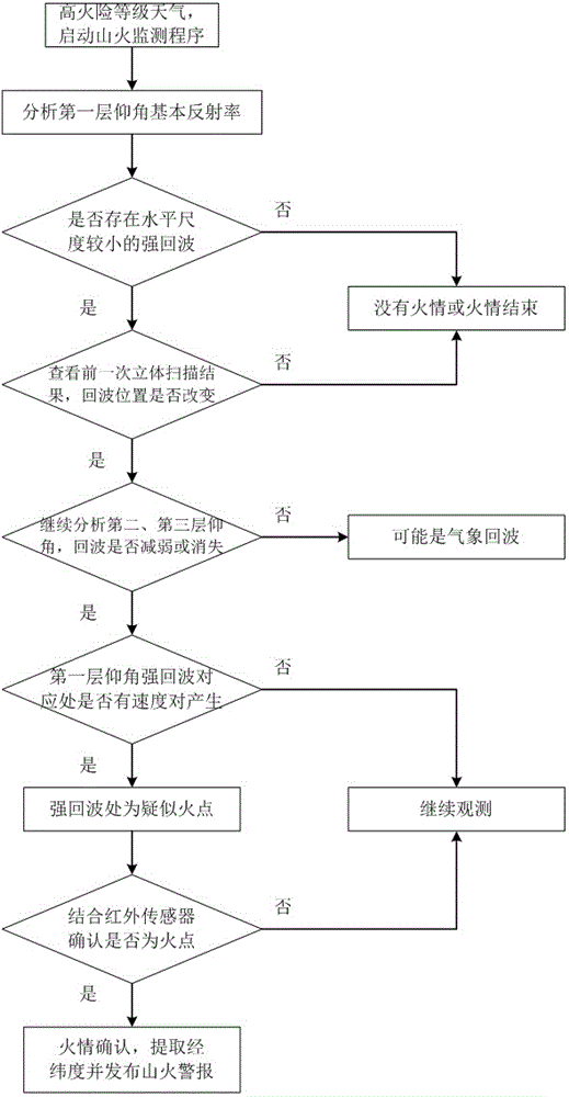
[0019] A small-scale radar-based mountain fire monitoring and positioning method of the present invention uses Doppler radar to perform three-dimensional scanning in a designated area, and finds suspected fire points that meet the characteristics of mountain fire echoes by analyzing the basic reflectivity and radial velocity. Combining the results of the infrared sensor to confirm the fire point, realize the monitoring and positioning of the mountain fire on the transmission line. The described mountain fire monitoring and positioning method based on s...


PUM


Abstract

The invention discloses a mountain fire monitoring and positioning method based on a small-sized radar. According to the mountain fire monitoring and positioning method based on the small-sized radar, the Doppler radar is used for performing stereoscopic scanning within an appointed region, a suspected fire point meeting the mountain fire echo feature can be found by analyzing the basic reflectivity and the radial speed; the fire point is confirmed according to a result of an infrared sensor, so that mountain fire monitoring and positioning for a power transmission line are realized. The mountain fire monitoring and positioning method based on the small-sized radar well solves the problem that the Doppler radar cannot effectively distinguish fire echo and precipitation echo with low intensity during fire condition monitoring and the problem that the infrared sensor is relatively low in space resolution by combining a Doppler radar stereoscopic scanning result and an infrared sensor result.

Description

technical field [0001] The invention relates to a method for monitoring and locating a mountain fire, in particular to a method for monitoring and locating a mountain fire based on a small radar. Background technique [0002] As we all know, forest fires will cause many difficulties and inconveniences to human production and life. Since ancient times, fire has brought serious disasters to human society with its huge destructive power. The power system is an important pillar for the development of the national economy of human society. The transmission lines used to transmit electric energy are widely distributed and often need to pass through complex mountain forests. The unique climate and topographical characteristics of the mountain forests are easy to cause wildfires. According to relevant information, the direct losses and indirect impacts caused by wildfires are huge. The applicant found in the research on wildfire monitoring of power system transmission lines that a...

Claims


Application Information

Patent Timeline
Patent Type & Authority Applications(China)
IPC IPC(8): G08B17/06G08B17/12
CPCG08B17/06G08B17/12
Inventor 王剑谷山强曹永兴冯万兴王海涛赵淳郭钧天姜文东梁文勇曾瑜王佩李涛何君吴驰丁国宁闵毅
Owner WUHAN NARI LIABILITY OF STATE GRID ELECTRIC POWER RES INST
Why Eureka
Try Eureka