Autonomous navigation system for drone and navigation method of autonomous navigation system

An autonomous navigation system and unmanned aerial vehicle technology, applied in the autonomous navigation system of unmanned aerial vehicles and its navigation field, can solve the problems of being unable to judge the route and flight path by itself, relying on GPS satellite signals, and unmanned aerial vehicles unable to realize autonomous flight

Active Publication Date: 2017-01-25
BEIJING INSTITUTE OF TECHNOLOGYGY
View PDF3 Cites 9 Cited by
  • Summary
  • Abstract
  • Description
  • Claims
  • Application Information

AI Technical Summary

Problems solved by technology

However, due to the limitations of the UAV platform, it is impossible to judge the route and flight path by itself, so there are few technologies that can truly realize autonomous navigation flight
[0003] At present, the solution to drone navigation is GPS navigation, which relies heavily on GPS satellite signals. When the signal is unstable or lost, the drone cannot fly autonomously.

Method used


Image

  • Autonomous navigation system for drone and navigation method of autonomous navigation system
  • Autonomous navigation system for drone and navigation method of autonomous navigation system
  • Autonomous navigation system for drone and navigation method of autonomous navigation system

Examples


Embodiment approach

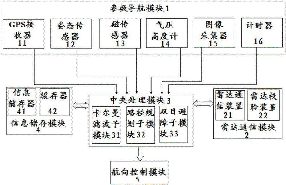
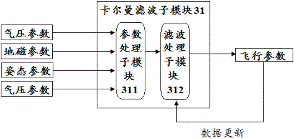
[0087] According to a preferred embodiment of the present invention, the parameter navigation module 1 includes a GPS receiver 11 , an attitude sensor 12 , a magnetic sensor 13 , a barometric altimeter 14 , an image collector 15 and a timer 16 .

[0088] Wherein, the GPS receiver 11 is used to receive GPS signals; the attitude sensor 12 is used to output the attitude parameter (attitude angle) of the drone; the magnetic sensor 13 is used to output the geomagnetic parameter of the location of the drone; The barometric altimeter 14 is used to output air pressure parameters and altitude parameters of the location of the drone; the image collector 15 is used to capture environmental information and output the information.

[0089] Wherein, the attitude parameters include the roll angle, pitch angle, yaw angle, etc. of the UAV; the geomagnetic parameter refers to the magnetic field size of the current position of the UAV, and the UAV can be positioned according to the magnetic field...


PUM


Abstract

The invention discloses an autonomous navigation system for a drone and a navigation method of the autonomous navigation system. The system comprises a parameter navigation module, a radar navigation module, a central processing module, an information storage module and a course control module, wherein the parameter navigation module, the radar navigation module and the information storage module outputs information to the central processing module, the information is processed optionally, and the processed information is output to the course control module for navigation. The navigation method includes: when a GPS signal is instable or lost temporally, the parameter navigation module outputs state parameters to the central processing module, and the state parameters are processed to obtain flight parameters; when the GPS signal is lost for a long time and the parameter navigation module fails, the radar navigation module is used to output course information; when the GPS signal is lost for a long time, the parameter navigation module fails and a radar signal cannot be received, the central processing module is used to perform route planning. By the system and the method, accurate navigation can be provided for the drone when the GPS signal is lost.

Description

technical field [0001] The invention relates to an unmanned aerial vehicle autonomous navigation system and a navigation method, in particular to an unmanned aerial vehicle autonomous navigation system that can cope with the situation of no GPS signal. Background technique [0002] UAVs have the advantages of small size and low cost, and with the rapid development of flight control technology, communication technology and electronic technology, the performance of UAVs has been continuously enhanced, and the types of UAVs have continued to increase, making them suitable for military and civilian applications. The demand is increasing and the usage rate is increasing day by day. However, due to the limitations of the UAV platform, it is unable to judge the route and flight path by itself, so there are very few technologies that can truly realize autonomous navigation and flight. [0003] At present, the solution to UAV navigation is GPS navigation, which relies heavily on GPS...

Claims


Application Information

Patent Timeline
IPC IPC(8): G01C21/00G01S19/48
CPCG01C21/005G01S19/48
Inventor 林时尧王伟林德福王江裴培王广山
Owner BEIJING INSTITUTE OF TECHNOLOGYGY
Why Eureka
Try Eureka