Indoor unmanned aerial vehicle accurate positioning and autonomous navigation system and method

A technology for autonomous navigation and precise positioning, applied in the field of unmanned aerial vehicles, it can solve the problems that the positioning accuracy cannot meet the requirements, difficult to promote, and technical limitations, and achieve the effect of expanding diversity, reliable performance and high accuracy

Active Publication Date: 2019-11-12
SHANGHAI UNIV OF ENG SCI
View PDF6 Cites 31 Cited by
  • Summary
  • Abstract
  • Description
  • Claims
  • Application Information

AI Technical Summary

Problems solved by technology

However, due to technical limitations and high cost of the above solutions, there is no mature product like GNSS (Global Navigation Satellite System) positioning technology that satisfies different users.
Either the positioning accuracy of these existing technologies cannot meet the requirements, or the cost is too high to be popularized

Method used


Image

  • Indoor unmanned aerial vehicle accurate positioning and autonomous navigation system and method
  • Indoor unmanned aerial vehicle accurate positioning and autonomous navigation system and method
  • Indoor unmanned aerial vehicle accurate positioning and autonomous navigation system and method

Examples


Embodiment Construction

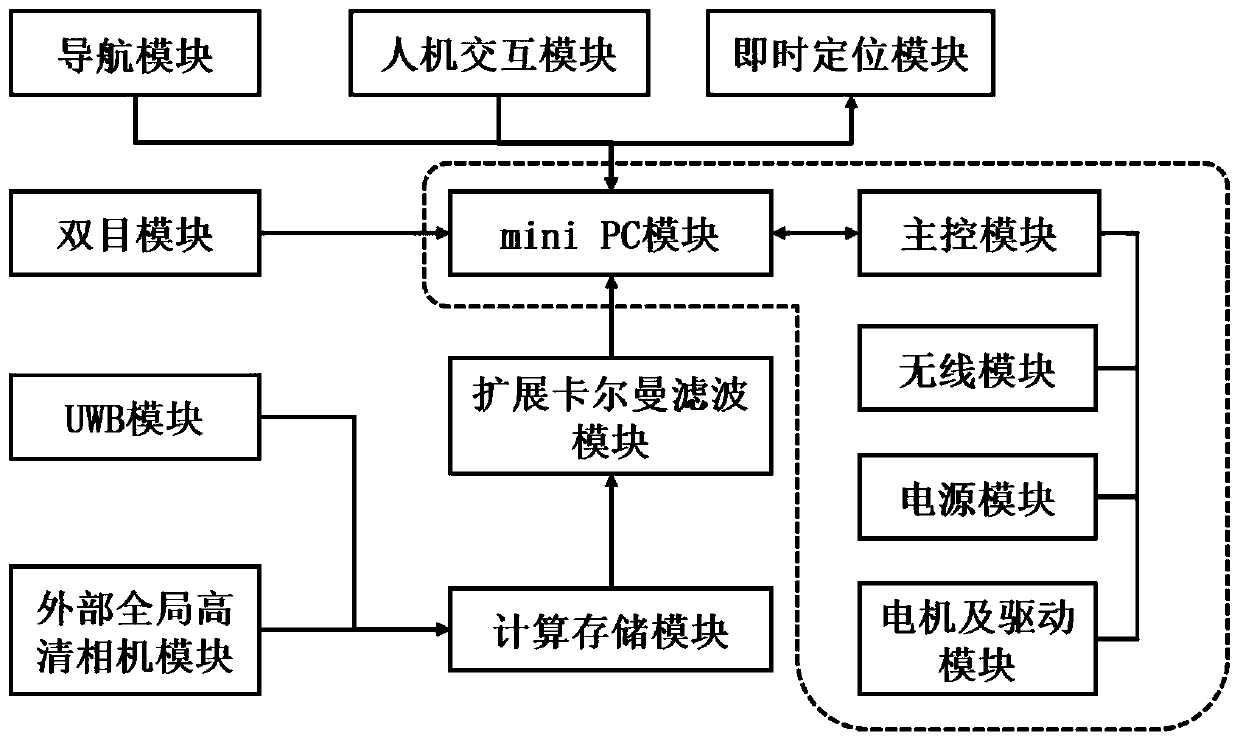
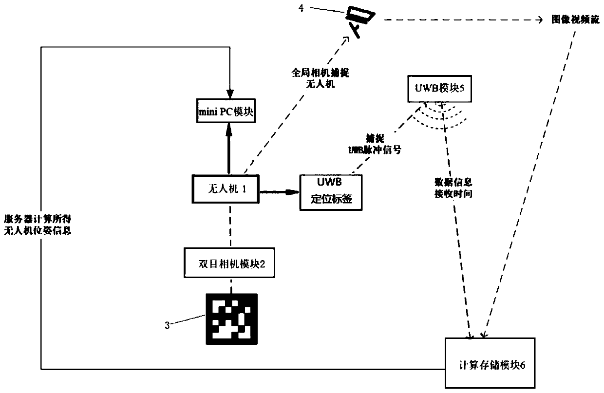
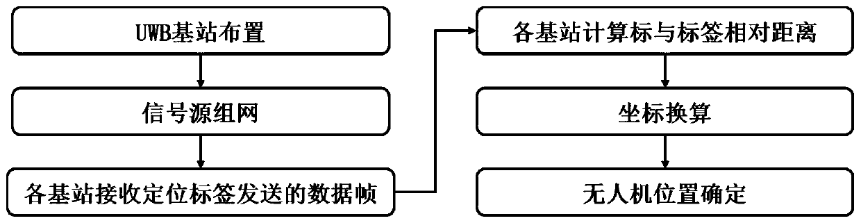
[0061] This embodiment is dedicated to providing a system for precise positioning and autonomous navigation of indoor drones based on the fusion of UWB (Ultra Wideband, ultra-wideband) and visual sensors. The fusion of UWB and visual sensors is an information processing process that uses computer technology to automatically analyze and synthesize the multi-source information and data of each sensor under certain criteria to complete the required decision-making and estimation.

[0062] Through the multi-level and multi-space information complementation and optimal combination processing of UWB and visual sensors, a consistent interpretation of the observed environment is finally produced. In this process, it is necessary to make full use of multi-source data for reasonable control and use, and the ultimate goal of information fusion is to derive more useful information based on the separate observation information obtained by each sensor, through multi-level and multi-faceted c...


PUM


Abstract

The invention provides an indoor unmanned aerial vehicle accurate positioning and autonomous navigation system. The system comprises an unmanned aerial vehicle; a binocular camera module which is usedfor capturing a ground two-dimensional code label to obtain position information of the unmanned aerial vehicle; an ultra-wideband UWB module which is used for capturing a positioning label on the unmanned aerial vehicle to obtain position information of the unmanned aerial vehicle; an external global high-definition camera module which is used for capturing mark points on the unmanned aerial vehicle to obtain position information of the unmanned aerial vehicle; an extended Kalman filtering module which is used for fusing the obtained position information of the unmanned aerial vehicle, predicting the attitude and position of the unmanned aerial vehicle and updating the attitude and position in real time; an instant positioning module which is used for instantly positioning the unmanned aerial vehicle; a navigation module which is used for providing an autonomous navigation function; a calculation and storage module which is used for calculating and storing position information of theunmanned aerial vehicle; and a man-machine interaction module which is used for providing a man-machine interaction function and setting a flight route of the unmanned aerial vehicle. The invention further provides a method for accurate positioning and autonomous navigation of the indoor unmanned aerial vehicle. The ststem is accurate in positioning, low in cost and reliable in performance.

Description

technical field [0001] The present invention relates to the technical field of unmanned aerial vehicles, and more specifically, to a system and method for precise positioning and autonomous navigation of indoor unmanned aerial vehicles based on the fusion of UWB (Ultra Wideband, ultra-wideband) and visual sensors. Background technique [0002] Outdoor UAV positioning and navigation often rely on differential GPS technology, while indoor GPS signals are weak, which cannot meet the needs of UAV real-time positioning and navigation. [0003] At present, there are many solutions for indoor positioning, such as WIFI positioning, ultrasonic positioning, Bluetooth positioning, geomagnetic positioning, satellite positioning, radio frequency identification, infrared positioning, Zigbee positioning, etc. However, due to technical limitations and high cost of the above solutions, there is no mature product like GNSS (Global Navigation Satellite System, Global Navigation Satellite Syste...

Claims


Application Information

Patent Timeline
Patent Type & Authority Applications(China)
IPC IPC(8): H04W4/02H04W4/021H04W4/33G01S13/06G01S13/66G01S5/02
CPCG01S5/0294G01S13/06G01S13/66H04W4/021H04W4/023H04W4/33
Inventor 高永彬方志军杨淑群
Owner SHANGHAI UNIV OF ENG SCI
Why Eureka
Try Eureka