Supercharge Your Innovation With Domain-Expert AI Agents!

Position analysis method

An analysis method and technology of geographic location information, applied in the field of location analysis, user home and work location analysis, can solve the problems of long location analysis, slow data access speed, heavy network IO load, etc., to reduce network IO load and efficiency. The effect of high and low capital risk

Active Publication Date: 2017-02-01
TIANZE INFORMATION IND
View PDF4 Cites 5 Cited by
  • Summary
  • Abstract
  • Description
  • Claims
  • Application Information

AI Technical Summary

Problems solved by technology

[0003] In the current existing solutions, the collected geographical information is generally stored in a relational database such as MySQL, and then all the data is read from the database regularly for location analysis. This method has the following defects: 1. When the amount of data is large, the speed of data access drops sharply, and it takes a long time to analyze the location. After a lot of testing, when the amount of data reaches hundreds of millions, the analysis takes more than 2 hours; 2. Each location All analysis needs to read relevant data from the database, and the network IO load is heavy

Method used


Image

  • Position analysis method
  • Position analysis method
  • Position analysis method

Examples


Embodiment Construction

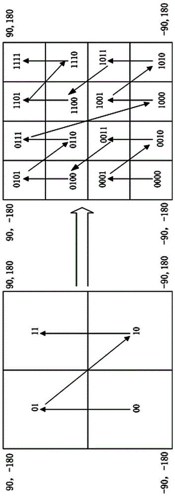
[0035] figure 1 As shown, GeoHash is an address encoding that can convert two-dimensional latitude and longitude into a one-dimensional string. Let's take (39.92324, 116.3906) as an example to introduce the GeoHash encoding algorithm: First, divide the latitude range (-90,90) into two intervals (-90, 0) and (0, 90). If the target latitude is in the front An interval, coded as 0, otherwise coded as 1. Since 39.92324 belongs to (0, 90), it is coded as 1. Then divide (0, 90) into two intervals (0, 45), (45, 90), and 39.92324 is located at (0, 45), so the code is 0; and so on until the accuracy meets the requirements, and the latitude is obtained The code is 1011 1000 1100 0111 1001;

[0036] Use the same algorithm to subdivide (-180, 180) in turn for longitude, and obtain the code of 116.3906 as 1101 00101100 0100 0100; then combine the codes of longitude and latitude, the odd digit is the latitude, and the even digit is the longitude, and the code is obtained 11100 11101 001...


PUM


Abstract

The invention discloses a position analysis method, and relates to the field of LBS (Location Based Service) analysis, in particular to a user household and working position analysis method based on MapReduce and GeoHash algorithms under the big data. Two MapReduce tasks are finished to realize position analysis. A first MapReduce task is executed by the following steps: converting two-dimensional geographic position information of users on a current day into GeoHash codes; performing statistics to obtain the numbers of times for which the users enter the same GeoHash codes, namely, position region codes on the current day; outputting GeoHash code statistics information to a Hadoop distributed file system (HDFS). A second MapReduce task is executed by the following steps: reading an intermediate result, namely, GeoHash code statistics information saved on a previous day and the current day; filtering out stale data; combining the code statistics information saved on the previous day and the current day to perform position analysis; outputting position information of the user and a new intermediate result.

Description

technical field [0001] A location analysis method of the present invention relates to the field of LBS analysis, in particular to a user family and work location analysis method based on MapReduce and GeoHash algorithms under big data. Background technique [0002] With the continuous development of science and technology, people carry more and more positioning tools, including mobile phones, professional handheld positioning terminals, wearable devices and personal vehicles with positioning terminals, etc. These positioning terminals will generate a large amount of two-dimensional geographic location information. By collecting and analyzing the generated two-dimensional geographic location information, the risk of financial leasing can be reduced (for example, a user purchases an electric vehicle through financial leasing, If the user cuts off the supply, the location of the user’s home or work can be found through positioning to avoid loss) or to improve the accuracy of ad...

Claims


Application Information

Patent Timeline
IPC IPC(8): G06F17/30
CPCG06F16/29G06F16/9537
Inventor 李鹏飞孙杰黄绍平陈智也薛扬陈进
Owner TIANZE INFORMATION IND
Features
  • R&D
  • Intellectual Property
  • Life Sciences
  • Materials
  • Tech Scout
  • Unparalleled Data Quality
  • Higher Quality Content
  • 60% Fewer Hallucinations
Learn More