Railway field investigation system based on 3DGIS and investigation method
A survey system and field technology, applied in the field of information technology, can solve the problems of low survey efficiency, long cycle, high cost, etc., and achieve the effect of reducing the workload of internal processing, improving the level of standardization, and reducing labor intensity
- Summary
- Abstract
- Description
- Claims
- Application Information
AI Technical Summary
Problems solved by technology
Method used
Image
Examples
Embodiment Construction
[0039] The system and method of the present invention will be described in detail below in conjunction with the accompanying drawings.
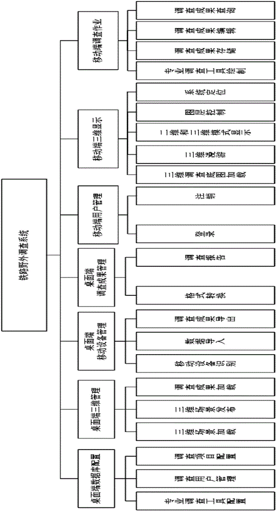
[0040] Such as figure 1 As shown, the railway field survey system based on 3DGIS of the present invention includes: a desktop database configuration module, a desktop three-dimensional management module, a desktop mobile device management module, a desktop survey result management module, a mobile user management module, and a mobile three-dimensional management module. Display module and mobile survey job module.
[0041] The desktop database configuration module is used for configuration of professional investigation tools, management of investigation users and configuration of investigation items. in:
[0042]The configuration of professional survey tools refers to the configuration of field survey tools for various fields of railway in the database, which are divided into three types of tools: point, line and surface. Each survey tool i...
PUM
 Abstract
Description
Claims
Application Information
 - R&D
- Intellectual Property
- Life Sciences
- Materials
- Tech Scout
- Unparalleled Data Quality
- Higher Quality Content
- 60% Fewer Hallucinations
Browse by: Latest US Patents, China's latest patents, Technical Efficacy Thesaurus, Application Domain, Technology Topic, Popular Technical Reports.
© 2025 PatSnap. All rights reserved.Legal|Privacy policy|Modern Slavery Act Transparency Statement|Sitemap|About US| Contact US: help@patsnap.com


