A spatial index construction method and device for mass point cloud data

A point cloud data and spatial indexing technology, applied in the field of data processing, can solve problems such as occupying a large memory space, difficult to determine the number of leaf node points, and not considering the distribution of data space, so as to improve query efficiency and reduce occupancy

Active Publication Date: 2017-02-15
BEIJING GREEN VALLEY TECH CO LTD +1
View PDF5 Cites 53 Cited by
  • Summary
  • Abstract
  • Description
  • Claims
  • Application Information

AI Technical Summary

Problems solved by technology

The grid index is easy to build and easy to encode, but it does not consider the spatial distribution of data when it is built, and it is not conducive to the rapid visualization of point cloud data; the quadtree index structure is simple, but it is difficult to determine when building a quadtree index for massive point clouds The number of points contained in the leaf nodes and the data distribution are uneven, the construction and query efficiency will be reduced; the KD tree index ha...

Method used


Image

  • A spatial index construction method and device for mass point cloud data
  • A spatial index construction method and device for mass point cloud data
  • A spatial index construction method and device for mass point cloud data

Examples


Embodiment 1

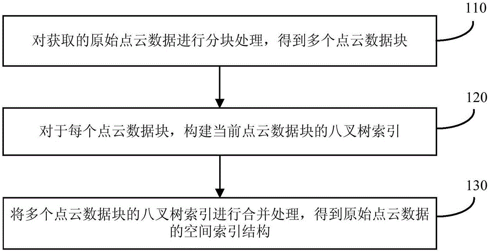
[0025] figure 1 A schematic flowchart of a method for constructing a spatial index of massive point cloud data provided in Embodiment 1 of the present invention, the method can be executed by a device for constructing a spatial index of massive point cloud data, wherein the device can be implemented by software and / or hardware, generally Can be integrated in terminals such as computers. Such as figure 1 As shown, the method includes:

[0026] Step 110, performing block processing on the acquired original point cloud data to obtain multiple point cloud data blocks.

[0027] Exemplarily, the obtained original point cloud data may be divided into blocks according to the operating environment information, and the operating environment information may include memory capacity, etc., where the memory capacity may specifically refer to the available memory capacity of the terminal. For example, the amount of data contained in each point cloud data block can be determined according ...

Embodiment 2

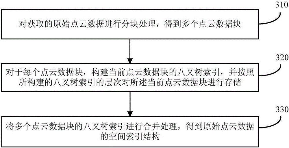
[0036] image 3It is a schematic flowchart of a method for constructing a spatial index of massive point cloud data provided by Embodiment 2 of the present invention. This embodiment is optimized on the basis of the above-mentioned embodiment. In this embodiment, the step "for each point cloud data block, construct the octree index of the current point cloud data block" is optimized as follows: for each point cloud data block, construct the octree index of the current point cloud data block, and compare all points according to the level of the constructed octree index The current point cloud data block is stored. Wherein, for the leaf nodes in the current level, store all the unstored data in the bounding box corresponding to the leaf nodes in the current level, and for the non-leaf nodes in the current level, randomly store all data in the current level according to the preset ratio Part of the bounding box corresponding to the non-leaf node has no data stored, and the sum o...

Embodiment 3

[0048] Figure 5 It is a schematic flowchart of a method for constructing a spatial index of massive point cloud data provided by Embodiment 3 of the present invention. This embodiment is optimized on the basis of the above embodiments. In this embodiment, multiple point cloud data blocks are combined After the octree index is merged and the spatial index structure of the original point cloud data is obtained, a step is added: based on the Levels of Detail (LOD) technology, according to the distance from the current viewpoint to the target point, the space of the original point cloud data is The corresponding data is scheduled for display in the index structure.

[0049] Correspondingly, the method of this embodiment includes the following steps:

[0050] Step 510, performing block processing on the acquired original point cloud data to obtain multiple point cloud data blocks.

[0051] Step 520, for each point cloud data block, construct an octree index of the current point ...


PUM


Abstract

The embodiments of the invention provide a spatial index construction method and device for mass point cloud data. The method comprises the steps of performing partitioning treatment on acquired original point cloud data to obtain a plurality of point cloud data blocks; for each point cloud data block, establishing an octree index of the current point cloud data block; performing combining treatment on the octree indexes of the multiple point cloud data blocks to obtain a spatial index structure of the original point cloud data. According to the technical solution, the conventional octree index structure is improved; partitioning treatment is performed on original point cloud data, so that mass point cloud data can be disassembled and thus memory space occupation in spatial index construction is reduced; after multiple octree indexes are combined, an octree index where target data are located can be found first and then target data can be searched for based on the found octree index in later query, so that the query efficiency is greatly increased.

Description

technical field [0001] Embodiments of the present invention relate to the technical field of data processing, and in particular to a method and device for constructing a spatial index of massive point cloud data. Background technique [0002] Lidar scanning technology is an emerging 3D data acquisition technology. Lidar scanners mounted on different platforms such as tripods, cars, airplanes and satellites can quickly acquire massive point cloud data. Point cloud data contains rich information such as latitude and longitude coordinates, intensity, multiple echoes and colors of each point, and has related applications in the fields of surveying and mapping, forestry, agriculture and digital cities. Currently commonly used lidar scanners, such as Riegl, Faro, and Leica, can generate tens of thousands of points per second, and the number of data points acquired by each scan can reach hundreds of thousands or millions, and the amount of data can reach several Ten to hundreds of...

Claims


Application Information

Patent Timeline
IPC IPC(8): G06F17/30
CPCG06F16/2246G01S17/89G01S7/4808G01S17/42G06F16/5854G06F16/9027G06F16/1737
Inventor 郭彦明
Owner BEIJING GREEN VALLEY TECH CO LTD
Why Eureka
Try Eureka