GIS-based marine disaster area extraction method

A disaster-affected area and extraction method technology, applied in image data processing, instruments, calculations, etc., can solve problems such as time-consuming and labor-intensive work, time-consuming and energy-consuming calculations, and failure to intuitively display the geographical location and influence range of the disaster-affected area, etc., to achieve Improve accuracy, make up for recognition failures, and improve work efficiency

Inactive Publication Date: 2017-03-15
SICHUANG TECH CO LTD
View PDF5 Cites 17 Cited by
  • Summary
  • Abstract
  • Description
  • Claims
  • Application Information

AI Technical Summary

Problems solved by technology

[0005] 1. UAV image collection and disaster-affected area calculation are independent of each other, which is not convenient for actual business operation. Manual area calculation requires a lot of time investment and repeated adjustment work, which is time-consuming and laborious
[0006] 2. The results of calculations that cost a lot of time and energy cannot be used well, and the geographical location and scope of influence of the disaster-affected area are not intuitively displayed, as well as the impact on the surrounding environment.

Method used


Image

  • GIS-based marine disaster area extraction method
  • GIS-based marine disaster area extraction method

Examples


Embodiment Construction

[0024] The technical solution of the present invention will be specifically described below in conjunction with the accompanying drawings.

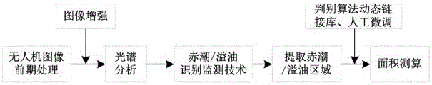
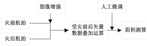
[0025] Such as Figure 1-2 As shown, a kind of GIS-based marine disaster area extraction method of the present invention comprises the following steps,

[0026] S1: Use the SIFT algorithm to perform spatial matching and alignment on several orthophoto remote sensing images with overlapping parts taken by drones, and extract feature vectors from local extreme points with direction information detected on images of different scale spaces ; Perform feature matching through the obtained feature vectors to achieve image stitching, and fuse into a remote sensing image panorama of a wide-angle scene;

[0027] S2: Establish the pixel coordinates of remote sensing images and their corresponding coordinates in the projected coordinate system by eliminating the difference between the coordinates of the pixels on the remote sensing image panorama im...


PUM


Abstract

The invention relates to a GIS-based marine disaster area extraction method. The method comprises the following steps: first, performing spatial matching alignment on a plurality of overlapped orthographic remote sensing images taken by an unmanned aerial vehicle by use of an SIFT algorithm to realize image splicing and get a wide-angle remote sensing panorama image; then, establishing the pixel coordinates of the remote sensing images, realizing geometric correction based on the coordinate transformation relationship between the coordinates of the pixels of the remote sensing panorama image in an image coordinate system and the ground coordinates, and superposing the geometrically-corrected remote sensing panorama image on a GIS platform through geographic coordinate location; and finally, implementing a red tide / oil spill identification and detection technology and vector data superposition operation before and after disaster on the remote sensing panorama image to realize red tide disaster and oil spill location and query and area measurement as well as typhoon and storm surge location and query and disaster area measurement. The method provides real-time field data for marine forecasters in rapid alert, and improves the ability of marine dynamic monitoring and disaster prevention and mitigation emergency monitoring.

Description

technical field [0001] The invention belongs to the field of marine disaster assessment, in particular to a method for extracting marine disaster area based on GIS. Background technique [0002] It is understood that the current monitoring of the location of large-scale marine disasters such as oil spills and red tides and the scope of disasters is mainly to use UAV remote sensing technology to collect remote sensing images of disaster areas, and the collected orthophoto remote sensing images are collected through interactive Mapping tools manually measure the area affected. UAV remote sensing monitoring can achieve emergency response without waiting for satellite transit or the altitude limit of traditional aerial remote sensing. On the other hand, it can overcome the defects of traditional satellite optical remote sensing technology in cloudy and cloudy weather, and greatly improve marine mobile monitoring. and disaster prevention and mitigation emergency monitoring capab...

Claims


Application Information

Patent Timeline
Patent Type & Authority Applications(China)
IPC IPC(8): G06T3/00G06T3/40G06T5/00G06T7/00
CPCG06T3/0068G06T3/4038G06T5/006G06T2207/10032G06T2207/20221G06T2207/30184
Inventor 郑楚飞林伟斌王小刚陈博嘉张火炬
Owner SICHUANG TECH CO LTD
Why Eureka
Try Eureka