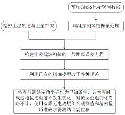
Method for determining co-seismic displacement by using single GNSS receiver
A receiver, displacement technology, applied in satellite navigation and positioning technology and application fields, can solve the problems of reduced accuracy and efficiency, difficulty in meeting earthquake monitoring requirements, long initialization time and re-initialization time, etc.
- Summary
- Abstract
- Description
- Claims
- Application Information
AI Technical Summary
Problems solved by technology
Method used
Image
Examples
Embodiment Construction
[0031] In order to facilitate those of ordinary skill in the art to understand and implement the present invention, the present invention will be described in further detail below in conjunction with the accompanying drawings and embodiments. It should be understood that the implementation examples described here are only used to illustrate and explain the present invention, and are not intended to limit this invention.
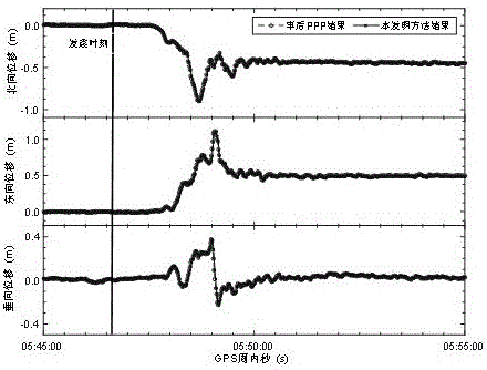
[0032] At 05:46:39 GPST on March 11, 2011, the Great East Japan Earthquake of Mw 9.0 occurred in the western Pacific Ocean about 130 kilometers east-southeast of the Oga Peninsula in Miyagi Prefecture. From the GEONET observation network ( http: / / www.gsi.go.jp / ) to select station 0183 for processing and description. Station 0183 is about 250 kilometers away from the epicenter, and the data sampling rate is 1 Hz. The selected data time range is from 05:45:00 to 05:55:00, a total of 10 minutes, including the entire earthquake process. It is worth noting tha...
PUM
 Abstract
Description
Claims
Application Information
 - R&D
- Intellectual Property
- Life Sciences
- Materials
- Tech Scout
- Unparalleled Data Quality
- Higher Quality Content
- 60% Fewer Hallucinations
Browse by: Latest US Patents, China's latest patents, Technical Efficacy Thesaurus, Application Domain, Technology Topic, Popular Technical Reports.
© 2025 PatSnap. All rights reserved.Legal|Privacy policy|Modern Slavery Act Transparency Statement|Sitemap|About US| Contact US: help@patsnap.com


