Chromatographic SAR three-dimensional point cloud generation method based on generalized orthogonal matching pursuit

An orthogonal matching tracking and three-dimensional point cloud technology, which is applied in the directions of radio wave reflection/re-radiation, re-radiation, and measurement devices, can solve problems such as difficult and effective imaging, uneven distribution, and limited number of tracks , to achieve the effect of reducing complexity, simplifying computational complexity, and ensuring the robustness of reconstruction

Inactive Publication Date: 2017-05-10
BEIJING UNIV OF CIVIL ENG & ARCHITECTURE
View PDF2 Cites 8 Cited by
  • Summary
  • Abstract
  • Description
  • Claims
  • Application Information

AI Technical Summary

Problems solved by technology

[0003] Tomographic SAR imaging using the Fourier transform focusing algorithm and the super-resolution tomography algorithm of spatial spectrum estimation must satisfy the Nyquist sampling theorem to recover the signal, and is limited by the limited number of tracks and uneven distribution. Difficult to image effectively

Method used


Image

  • Chromatographic SAR three-dimensional point cloud generation method based on generalized orthogonal matching pursuit
  • Chromatographic SAR three-dimensional point cloud generation method based on generalized orthogonal matching pursuit
  • Chromatographic SAR three-dimensional point cloud generation method based on generalized orthogonal matching pursuit

Examples


Embodiment 1

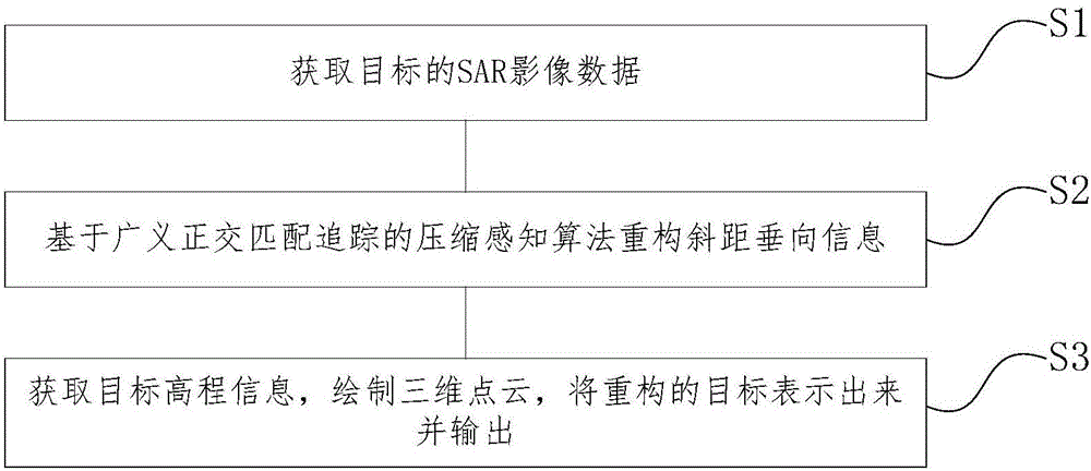
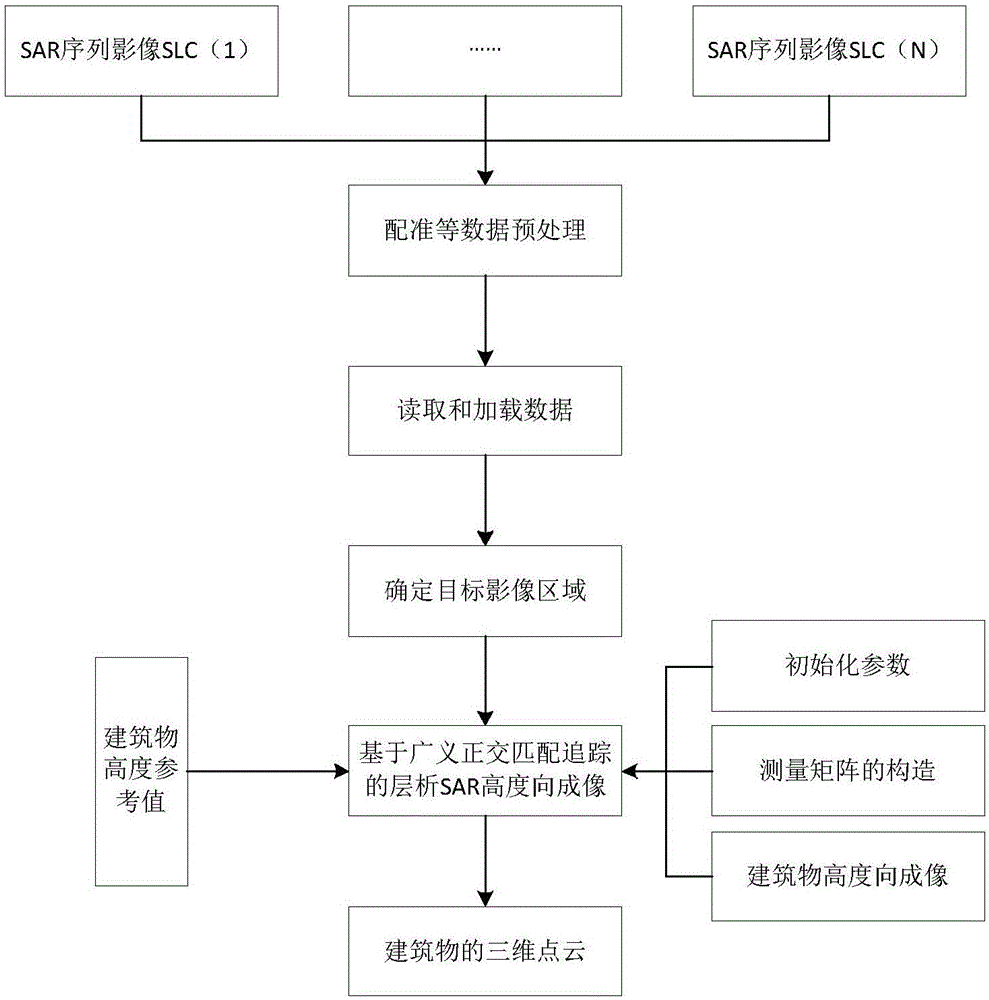
[0035] figure 1 and figure 2 A tomographic SAR urban building three-dimensional point cloud generation method is shown, comprising the following steps:

[0036] S1. Obtain multi-temporal SAR image data of the target building;

[0037] S2. Focusing in the height dimension (vertical slant distance) through a compressed sensing algorithm based on generalized orthogonal matching pursuit;

[0038] S3. Obtain the elevation information of the target, encrypt the point cloud by interpolation, express and output the reconstructed target.

[0039] Preferably, the step S1 specifically includes: acquiring N-scene two-dimensional SAR image data of the same target at different times and different track positions by the sensor.

[0040] Preferably, the two-dimensional SAR image data includes orbit altitude, revisit period, incident angle range, azimuth resolution, distance resolution, single-channel scene size, and maximum acquisition length.

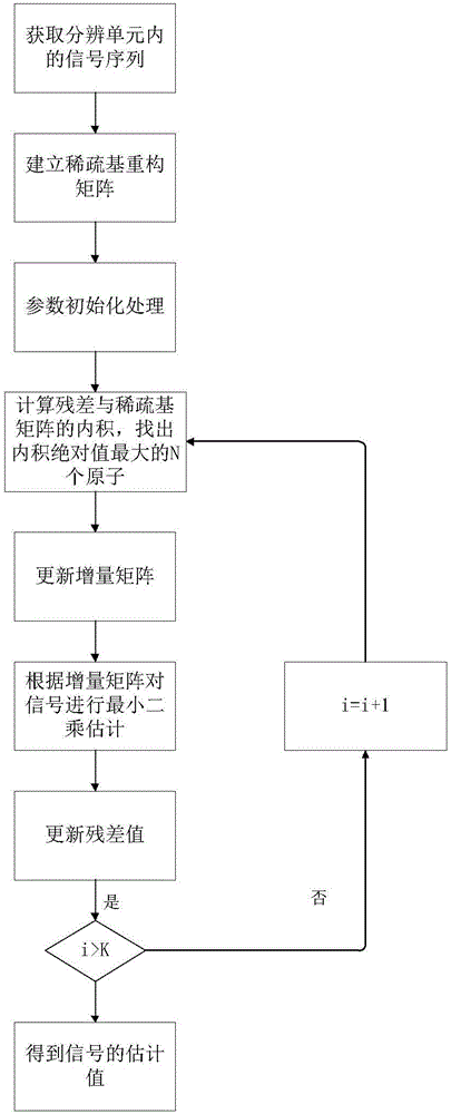
[0041] As preferably, said step S2 specifi...

Embodiment 2

[0064] Select 14 scenes of ascending orbit images under the "TerraSAR-X" HH polarization mode in the Beijing area from 2011 to 2013 as the experimental data. 3.3m, and take Beijing Pangu Seven Star Hotel as an example object. In the example, the image in December 2011 is the main image, and the other images are the secondary images. After SAR image registration, single building selection and cropping, image de-skewing and phase error compensation and other data preprocessing, the example building is realized based on the generalized orthogonal matching tracking algorithm according to the steps described in the above-mentioned part 5. 3D imaging, the results are as follows Figure 4 As shown, the point cloud after interpolation and encryption is as follows Figure 5 shown.


PUM


Abstract

The invention discloses a chromatographic SAR three-dimensional point cloud generation method based on generalized orthogonal matching pursuit, and the method comprises the following steps: S1, obtaining multi-temporal SAR image data of a target building; S2, carrying out the high-dimensional (slant-range vertical) focusing through a compressed sensing algorithm based on the generalized orthogonal matching pursuit; S3, obtaining the target elevation information, encrypting point cloud through an interpolation method, and expressing and outputting a reconstructed target. The method obtains the high-dimensional information of the target building through the compressed sensing algorithm based on the generalized orthogonal matching pursuit. During iterative operation, N atoms is selected at each time from optimal atoms at most, thereby guaranteeing the robustness of the algorithm while simplifying the calculation complexity of an orthogonal matching pursuit algorithm, and overcoming the constraint that can a signal be restored only if a conventional chromatographic SAR imaging method has to meet the Nyquist sampling law.

Description

technical field [0001] The present invention relates to the technical field of electronic signal processing, and more specifically, to a tomographic SAR three-dimensional point cloud generation method based on generalized orthogonal matching pursuit. Background technique [0002] Most of the current tomographic SAR methods for generating 3D point clouds of urban buildings use Fourier transform focusing algorithms and super-resolution tomography algorithms (MUSIC, APES, etc.) for spatial spectrum estimation. (International Geoscience and Remote Sensing Symposium) is to decompose the eigenvalue of the covariance matrix of the observed signal to obtain the estimation of the noise subspace, and then use the orthogonal characteristics of the signal subspace and the noise subspace to detect the signal. The super-resolution effect can be obtained on the Direction of Arrival (DOA), and then the DOA estimation can be converted into a height estimation through geometric transformation...

Claims


Application Information

Patent Timeline
Patent Type & Authority Applications(China)
IPC IPC(8): G01S13/90
CPCG01S13/9005G01S13/9004G01S13/9027
Inventor 张学东庞蕾刘慧何曙光毕辉王勇艾立萍孙萌鑫李林泽王志良
Owner BEIJING UNIV OF CIVIL ENG & ARCHITECTURE
Why Eureka
Try Eureka