Urban mapping method and device

A city and target technology, applied in the field of remote sensing applications, can solve problems such as complex operations, many preprocessing steps, and insufficient algorithm effects, and achieve the effect of simple and convenient processing, high degree of automation, and easy promotion and use

Inactive Publication Date: 2017-05-10
SHENZHEN INST OF ADVANCED TECH CHINESE ACAD OF SCI
View PDF3 Cites 3 Cited by
  • Summary
  • Abstract
  • Description
  • Claims
  • Application Information

AI Technical Summary

Problems solved by technology

[0003] Due to the wide coverage of remote sensing imagery, it has become an important data source for monitoring urban development. Low spatial resolution remote sensing imagery can cover a large area, but due to its low spatial resolution, it cannot show the details of the city.
At present, the research on urbanization based on remote sensing images mainly has the following areas to be strengthened: the definition of cities is not clear, the spatial resolution of remote sensing images is too low, and the existing algorithms are not effective enough
[0004] Because of its higher spatial resolution (30m), Landsat remote sensing images have become a key data source for the study of urbanization. However, Landsat remote sensing images only use optical images, and it is difficult to improve the phenomeno...

Method used


Image

  • Urban mapping method and device
  • Urban mapping method and device
  • Urban mapping method and device

Examples


Embodiment 1

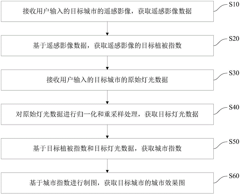
[0056] figure 1 A flowchart showing the city mapping method in this embodiment. The urban mapping method is based on the phenomenon that the urban light data increases with the decrease of the vegetation index. By processing the vegetation index and light data, the city index of the target city can be obtained, and the map of the target city can be obtained based on the city index. City renderings. Such as figure 1 As shown, the city mapping method includes the following steps:

[0057] S10: Receive the remote sensing image of the target city input by the user, and obtain remote sensing image data.

[0058] Among them, the remote sensing image can be a medium-low resolution remote sensing image. Since the medium-low resolution remote sensing image has the advantages of wide image coverage and low price, it has the advantages of wide coverage and low price when applied in urban mapping, which can effectively reduce Drawing costs.

[0059] In this embodiment, the medium-res...

Embodiment 2

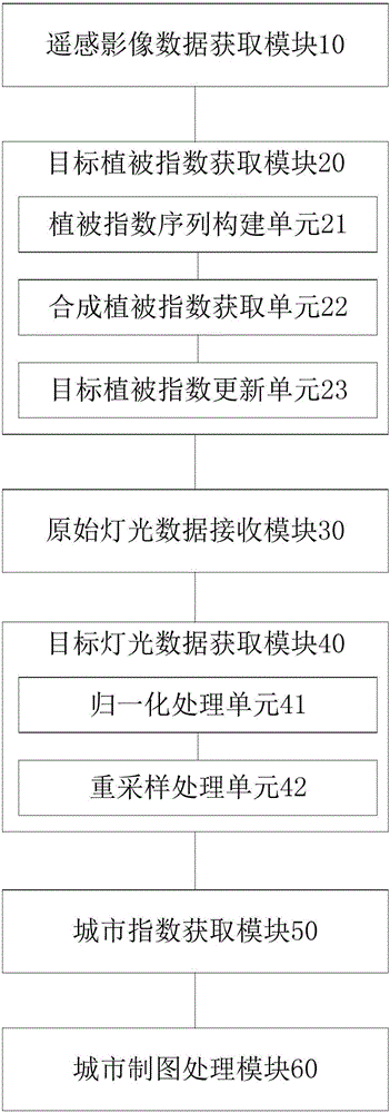
[0094] image 3 A functional block diagram of the city mapping device in this embodiment is shown. The urban mapping device is based on the phenomenon that the urban light data increases as the vegetation index decreases. By processing the vegetation index and light data, the city index of the target city can be obtained, and the map of the target city can be obtained based on the city index. City renderings. Such as image 3 As shown, the urban mapping device includes a remote sensing image data acquisition module 10 , a target vegetation index acquisition module 20 , a raw lighting data receiving module 30 , a target lighting data acquisition module 40 , an urban index acquisition module 50 and an urban mapping processing module 60 .

[0095] The remote sensing image data acquiring module 10 is configured to receive the remote sensing image of the target city input by the user, and acquire the remote sensing image data.

[0096] Among them, the remote sensing image can be...


PUM


Abstract

The invention discloses an urban mapping method and device. The urban mapping method comprises the following steps of receiving a remote sensing image of a target city input by a user and obtaining remote sensing image data; obtaining a target vegetation index of the remote sensing image based on the remote sensing image data; receiving original light data of the target city input by the user; carrying out normalization and re-sampling processing on the original light data to obtain target light data; obtaining a city index based on the target vegetation index and the target light data; and carrying out mapping based on the city index to obtain a city effect drawing of the target city. The urban mapping method has simple and convenient processing process, high automation degree and high processing efficiency and does not need a complicated preprocessing process; and furthermore, the city index is obtained based on the target vegetation index and the target light data, the city index is utilized to carry out mapping, the mapping effect is good, the precision is high and the method is easy to popularize and apply.

Description

technical field [0001] The invention relates to the technical field of remote sensing applications, in particular to a method and device for urban mapping. Background technique [0002] Cities, due to the concentration of population and resources, have become the focus of research on global climate change and human activities. Although the city occupies only 2% of the land area, it occupies 50% of the population, produces 90% of GDP, and emits 70% of greenhouse gases. In order to better monitor the impact of urban development on human beings, a large number of studies The scale range and high-precision monitoring level have become a hot issue for exploration. [0003] Due to the wide coverage of remote sensing imagery, it has become an important data source for monitoring urban development. Low spatial resolution remote sensing imagery can cover a large area, but due to its low spatial resolution, it cannot show the details of the city. At present, the urbanization researc...

Claims


Application Information

Patent Timeline
IPC IPC(8): G06K9/00G06T11/00
CPCG06T11/00G06V20/188
Inventor 张清凌王志盼钱静陈凯
Owner SHENZHEN INST OF ADVANCED TECH CHINESE ACAD OF SCI
Why Eureka
Try Eureka