Positioning data based service line patrol assessment method

A technology for positioning data and services, which is applied in satellite radio beacon positioning systems, radio wave measurement systems, instruments, etc.

Active Publication Date: 2017-05-24
ENJOYOR COMPANY LIMITED
View PDF4 Cites 11 Cited by
  • Summary
  • Abstract
  • Description
  • Claims
  • Application Information

AI Technical Summary

Problems solved by technology

This method focuses on solving the assessment matching problem of multi-vehicle patrol tasks in the mobile police assessment process

Method used


Image

  • Positioning data based service line patrol assessment method
  • Positioning data based service line patrol assessment method
  • Positioning data based service line patrol assessment method

Examples


Embodiment

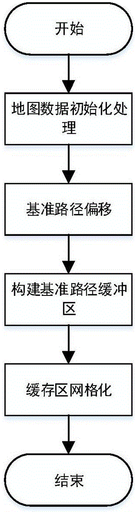
[0043] Embodiment: A method for assessing service patrol lines based on positioning data involves mobile service assessment based on positioning information. Through automatic matching of positioning data and patrol routes, the assessment and attendance of service management is realized, which specifically includes the following steps:

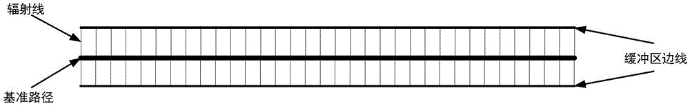
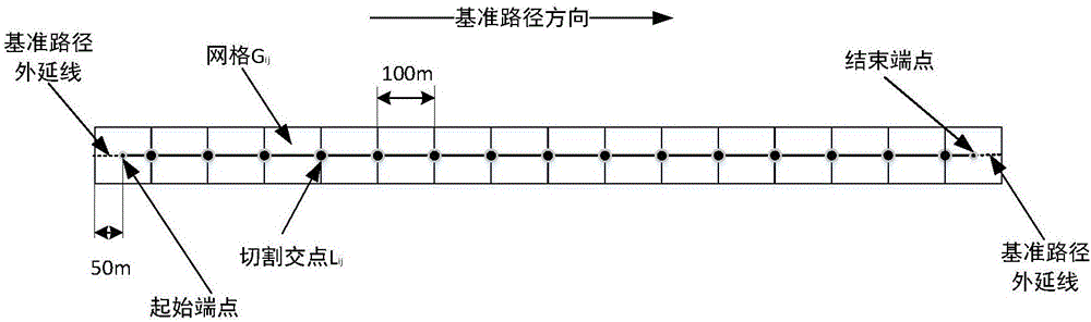
[0044] (1) The steps of constructing the reference path grid, such as figure 1 Shown:

[0045] Step 1-1. Road space data initialization

[0046] Road spatial data includes road centerline data, road data with directions, spatial point data, and spatial block data. This method needs to match the reference path through the original road space data, and uses the original road centerline data as the basic road space data.

[0047] Step 1-2, benchmark path matching generation

[0048] Before the assessment business, the user defines the line inspection path; because there are some deviations from the original road space data when drawing the lin...


PUM


Abstract

The invention relates to positioning data based mobile police service management, and particularly relates to a positioning data based service line patrol assessment method. The positioning data based service line patrol assessment method comprises buffer area establishment and segmentation of a line patrol path, mapping of positioning data, interpolation compensation of the positioning data and restoration compensation of the line patrol path; the line patrol path forms a grid through establishing and segmenting a buffer area, the positioning data is mapped to the grid according to the spatial position and distance, labeling is performed on the grid, data coverage of the grid is compensated in an interpolation manner so as to form relatively complete grid data mapping, and finally a line patrol path is fitted through the grid. The method provided by the invention emphatically solves a problem of positioning data based multi-vehicle line patrol attendance matching in service management, problems of positioning data line matching of multiple vehicles on multiple lines, insufficient positioning data coverage density, loss of positioning data and the like exist when attendance checking is performed on service patrolling through the positioning data, and the problems are solved through data buffering for the line patrol path and compensation for positioning data coverage.

Description

technical field [0001] The invention relates to the field of public security service line inspection assessment, in particular to a service line inspection assessment method based on positioning data. Background technique [0002] With the continuous improvement of the level of computer information, government agencies or enterprises have undergone a certain degree of innovation in the management of internal personnel, especially in the management of personnel attendance and assessment. Mobile assessment and attendance with GPS or Beidou positioning, wireless communication and GIS geographic information system as the core technology has become an important way for internal management in many industries. The execution status of the task. [0003] As an important part of the system application, the positioning system's positioning accuracy and continuity directly determine the effect of the mobile assessment and attendance business. Although the current positioning system ha...

Claims


Application Information

Patent Timeline
Patent Type & Authority Applications(China)
IPC IPC(8): G01S19/14G01S19/42
CPCG01S19/14G01S19/42
Inventor 徐建军王辉周宏伟邵小华叶日诚吕志鹏
Owner ENJOYOR COMPANY LIMITED
Why Eureka
Try Eureka