BIM simulation and aerial photography combined construction management and control method and system

A combination and aerial photography technology, applied in the field of construction management and control methods and systems combining BIM simulation and aerial photography, can solve problems such as untimely, convenient construction progress and construction effects, backward recording methods, and corporate financing, so as to facilitate overall regulation , increase profits, improve work efficiency

Inactive Publication Date: 2017-06-23
SHENZHEN GRANDLAND DECORATION GROUP
View PDF1 Cites 34 Cited by
  • Summary
  • Abstract
  • Description
  • Claims
  • Application Information

AI Technical Summary

Problems solved by technology

In the existing technology, the physical engineering information (not limited to time, quality, progress, safety, construction practices, etc.) Drawings, etc. classify the corresponding engineering information one by one, the work is cumbersome, and the recording method is relatively backward. The project manager cannot timely, conveniently and accurately grasp the overall progress of the building entity and the constru

Method used


Image

  • BIM simulation and aerial photography combined construction management and control method and system
  • BIM simulation and aerial photography combined construction management and control method and system
  • BIM simulation and aerial photography combined construction management and control method and system

Examples


Embodiment Construction

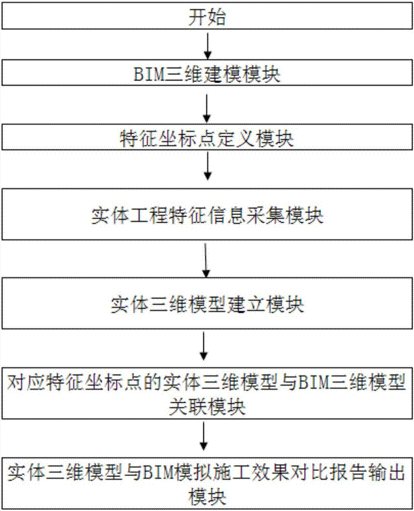
[0023] Such as figure 1 As shown, the construction control system combining BIM simulation and aerial photography includes a BIM 3D modeling module, a feature coordinate point definition module, a solid engineering feature information collection module, a solid 3D model building module, a solid 3D model corresponding to feature coordinate points and a BIM 3D model. Model association module, entity 3D model and BIM simulation construction effect comparison report output module.

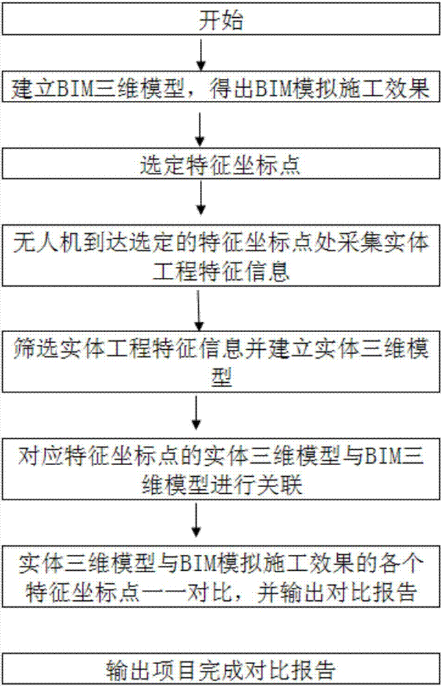
[0024] Such as figure 2 As shown, the construction control system combining BIM simulation and aerial photography can be realized by a construction control method combining BIM simulation and aerial photography provided by the present invention. The drone has functions such as camera, photograph, positioning, scanning, temporary storage of information, information transmission, etc. In the embodiment, a consumer-grade drone is preferably used as a carrier, such as DJI's Phantom series drones.

[002...


PUM


Abstract

The invention discloses a BIM simulation and aerial photography combined construction management and control method and system. The method comprises the following steps of outputting a BIM three-dimensional model of a building; according to demands for information acquisition, selecting a characteristic coordinate point needed to be tracked and recorded in advance on the BIM three-dimensional model; an unmanned aerial vehicle arriving at the corresponding position matched with the selected characteristic coordinate point of the entity building, collecting entity engineering characteristic information, and sending the collected entity engineering characteristic information to a monitoring computer; establishing an entity three-dimensional model on the monitoring computer with the entity engineering characteristic information of the same positioning coordinate point which is sent to the monitoring computer by the unmanned aerial vehicle; matching, associating and comparing the entity three-dimensional model with the BIM three-dimensional model of the same characteristic coordinate point in one-to-one manner, automatically finding "matched" and "unmatched" items of the both models, and outputting a project completion comparison report. The system and the method can timely, conveniently and accurately master the construction progress and the construction effect of the building entity, the construction progress can be integrally regulated and controlled conveniently, the construction period is shortened, and the profit is improved.

Description

technical field [0001] The invention relates to the application field of the combination of BIM three-dimensional model and aerial photography, in particular to a construction control method and system combining BIM simulation and aerial photography. Background technique [0002] In the field of large-scale building construction, several construction groups are usually required to undertake the construction in different areas. The manager needs to coordinate and monitor the progress of each construction area as a whole, and make the progress of each construction team consistent as much as possible. On the basis of ensuring construction quality shorten the construction time. In the existing technology, the physical engineering information (not limited to time, quality, progress, safety, construction practices, etc.) Drawings, etc. classify the corresponding engineering information one by one, the work is cumbersome, and the recording method is relatively backward. The projec...

Claims


Application Information

Patent Timeline
IPC IPC(8): G06Q10/06G06Q50/08G06T17/00
CPCG06Q10/0639G06Q50/08G06T17/00
Inventor 刘卫国彭俊明
Owner SHENZHEN GRANDLAND DECORATION GROUP
Why Eureka
Try Eureka