Indoor positioning method and indoor positioning system based on Bluetooth, Wi-Fi, and inertial navigation technologies

An indoor positioning and Bluetooth technology, applied in the field of navigation, can solve the problems of high power consumption, low precision, and unsatisfactory high-precision real-time positioning and navigation, and achieve the effect of easy implementation and low complexity

Active Publication Date: 2017-06-23
深圳墨兔科技有限公司
View PDF3 Cites 27 Cited by
  • Summary
  • Abstract
  • Description
  • Claims
  • Application Information

AI Technical Summary

Problems solved by technology

[0003] However, the existing indoor positioning technology has high computational complexity and is not suitable for application on handheld terminals; it consumes a lot of power and is not suitable for application on mobile terminals that use batteries; it has low accuracy and large delay, which does not meet high-precision real-time The need for positioning and navigation

Method used


Image

  • Indoor positioning method and indoor positioning system based on Bluetooth, Wi-Fi, and inertial navigation technologies
  • Indoor positioning method and indoor positioning system based on Bluetooth, Wi-Fi, and inertial navigation technologies
  • Indoor positioning method and indoor positioning system based on Bluetooth, Wi-Fi, and inertial navigation technologies

Examples


Embodiment 1

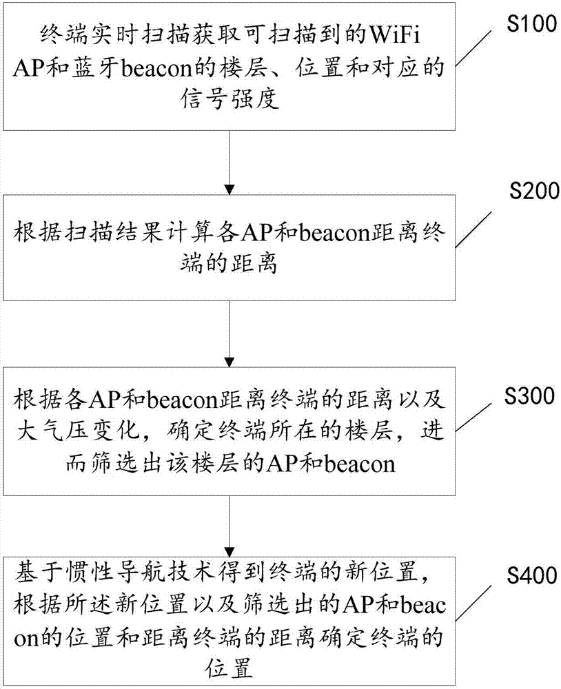
[0039] refer to figure 1 , an indoor positioning method is disclosed in Embodiment 1, the method includes periodically performing the following steps:

[0040] S100. The terminal scans in real time to obtain the floors, locations and corresponding signal strengths of scannable WiFi APs and Bluetooth beacons;

[0041] Specifically, the terminal scans the APs and beacons in real time, records the device information of the APs and the beacons, and acquires the floors and locations of the APs and the beacons according to the device information. Wherein, the device information includes: a MAC address or SSID for uniquely identifying the AP, and one or any combination of the following three records for uniquely identifying the beacon: UUID, major, and minor.

[0042]For example, in a specific implementation manner, the scanning data records of WiFi APs are shown in Table 1, and the scanning data records of Bluetooth beacons are shown in Table 2.

[0043] Table 1 Scanning data of W...

Embodiment 2

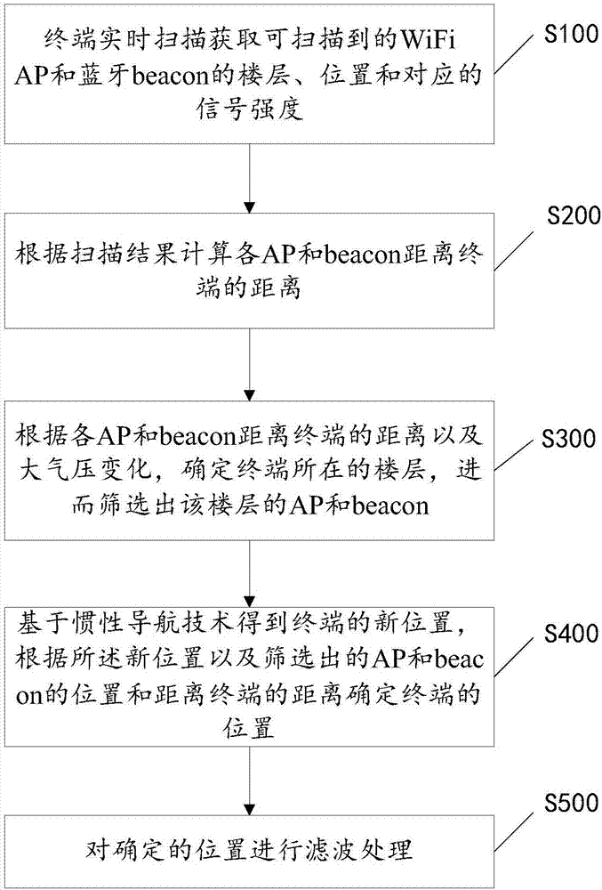
[0074] In this embodiment, the following step S500 is added on the basis of the first embodiment, specifically:

[0075] S500. Perform filtering processing on the position determined in step S400.

[0076] In this step, a variety of different filtering techniques can be used, such as Kalman filtering, particle filtering, etc., and a simple smoothing filter can also be used, as shown in the following formula:

[0077]

[0078] In the formula, α is a smoothing coefficient with a range of [0, 1], which can be determined according to the actual moving speed of the terminal, for example, 0.2 can be used. x new 、y new is the position of the finalized terminal, x t-1 、y t-1 Indicates the position of the terminal at the previous moment, x t 、y t is the location of the terminal determined in step S400.

Embodiment 3

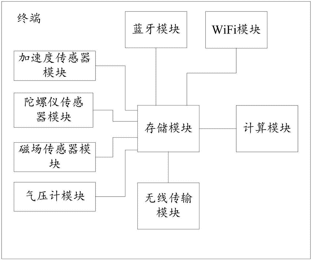
[0080] This embodiment discloses an indoor positioning system that belongs to the same inventive concept as the above positioning method, and the system includes a terminal, a WiFi AP and a Bluetooth beacon. The terminal includes: a WiFi module, a Bluetooth module, a barometer module, a calculation module, a storage module, a wireless transmission module, a magnetic field sensor module, a gyroscope sensor module, and an acceleration sensor module.

[0081] WiFi module, bluetooth module are used to perform scanning. The storage module is used for storing data, including scanning data, data of various sensors and barometers, and calculation data of the calculation module. The calculation module is used to retrieve data from the storage module to execute all the calculations in the above indoor positioning method. The wireless transmission module is used to communicate with the positioning center to obtain the data needed in the calculation, such as the position table of AP and ...


PUM


Abstract

The invention discloses an indoor positioning method and an indoor positioning system based on Bluetooth, Wi-Fi, and inertial navigation technologies. The method comprises the following steps performed periodically: S100, a terminal acquires the floors, positions and corresponding signal strength of available Wi-Fi APs and Bluetooth Beacons through real-time scanning; S200, the distances of each AP and each beacon from the terminal are calculated according to the scanning result; S300, the floor where the terminal is located is determined according to the distances of each AP and each beacon from the terminal and the change in atmospheric pressure, and the APs and the beacons in the floor are screened out; and S400, the new position of the terminal is obtained based on the inertial navigation technology, and the position of the terminal is determined according to the new position, the positions of the APs and the beacons screened out and the distances from the APs and the beacons screened out from the terminal. As a variety of positioning technologies, namely, the Bluetooth, Wi-Fi, and inertial navigation technologies, are combined, the accuracy of positioning is improved effectively, and the delay is low. The algorithm is of low complexity, and is easy to implement on a mobile terminal.

Description

technical field [0001] The present invention relates to the field of navigation, in particular to an indoor positioning method and system integrated with Bluetooth, WiFi and inertial navigation technologies. Background technique [0002] Indoor positioning refers to the use of indoor positioning technology as an auxiliary positioning of satellite positioning when satellite positioning cannot be used in the indoor environment to solve the problem that satellite signals are weak when they reach the ground and cannot penetrate buildings. Finally locate the current position of the object. Common indoor positioning technologies include cellular positioning of communication networks, Wi-Fi, Bluetooth, infrared, ultra-wideband, RFID, ZigBee and ultrasonic. There is also a positioning algorithm that integrates Bluetooth and WiFi, and the seamless coverage of the positioning network is guaranteed through the deployment of Bluetooth base stations and WiFi APs. [0003] However, the ...

Claims


Application Information

Patent Timeline
Patent Type & Authority Applications(China)
IPC IPC(8): H04W4/00H04W4/02H04W4/04
CPCH04W4/023H04W4/043H04W4/80
Inventor 易友文李东蔚莫梦舒
Owner 深圳墨兔科技有限公司
Why Eureka
Try Eureka