Classification method for airborne LIDAR power inspection point cloud

A technology of electric power inspection and classification method, which is applied in the direction of computer parts, instruments, character and pattern recognition, etc., to achieve low project cost, shorten the cycle of data processing, and improve the effect of accuracy and efficiency

Inactive Publication Date: 2017-06-27
BEIJING FORESTRY UNIVERSITY
View PDF7 Cites 23 Cited by
  • Summary
  • Abstract
  • Description
  • Claims
  • Application Information

AI Technical Summary

Problems solved by technology

[0009] In order to solve many problems existing in the airborne LIDAR point cloud data classification of the existing surveying and mapping remote sensing classification t

Method used


Image

  • Classification method for airborne LIDAR power inspection point cloud
  • Classification method for airborne LIDAR power inspection point cloud
  • Classification method for airborne LIDAR power inspection point cloud

Examples


Embodiment Construction

[0033] In order to clearly illustrate the technical features of this solution, the present invention will be described in detail below through specific implementation modes and in conjunction with the accompanying drawings.

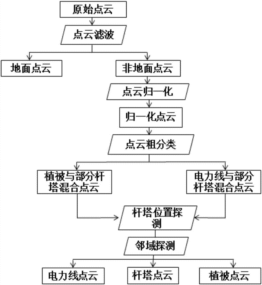
[0034] Such as figure 1 As shown in the method flow, the present invention: an airborne LIDAR power inspection point cloud classification method, said method comprising the following steps:

[0035] Step 1, Distinguish between ground points and non-ground points: use the morphological reverse interpolation filtering algorithm to filter the original power inspection point cloud, and divide it into two parts: ground points and non-ground points. First divide the original point cloud data into grids, set the grid width to d, detect the lowest point of elevation in each grid as the initial ground seed point, and first perform morphology on the point cloud data according to the initial ground point and the size of the corrosion window Corrosion operation, and...


PUM


Abstract

The invention discloses a classification method for airborne LIDAR power inspection point cloud data. After the airborne LIDAR power inspection point cloud data is acquired and denoising preprocessing is performed on an original point cloud, a classification algorithm for different ground object types based on the airborne LIDAR power inspection point cloud data is constructed; first, separation of a ground point and a non-ground point is realized according to a designed point cloud filtering algorithm; and then high-precision automatic extraction of ground objects such as power towers, power lines and vegetation in original point cloud data is performed in sequence. Through the method, the classification precision and automation degree of the power inspection point cloud data can be greatly improved, and a guarantee is provided for power line inspection failure checking.

Description

[0001] 1. Technical field [0002] The invention relates to a data classification technology in the field of surveying, mapping and remote sensing, in particular to a method for classifying point cloud data of electric power inspection laser radar under the airborne LIDAR technology. [0003] 2. Technical background [0004] LiDAR (Light Detection And Ranging, LiDAR) is an active remote sensing technology that measures the distance between the sensor and the target through the laser emitted by the sensor. LiDAR data is an irregularly distributed point set in three-dimensional space, and the distribution form in three-dimensional space presents a discrete "point cloud". Airborne LIDAR can be used to inspect the transmission line, and the faults and hidden dangers of the transmission line can be checked through the inspection point cloud data. Among them, the detection of the distance between the ground object and the power line is an important content, which needs to be obtained...

Claims


Application Information

Patent Timeline
IPC IPC(8): G06K9/00G06K9/62
CPCG06V20/13G06F18/241
Inventor 张晓丽瞿帅张凝
Owner BEIJING FORESTRY UNIVERSITY
Why Eureka
Try Eureka