A real-time positioning method for unmanned vehicles based on laser reflection intensity

A technology of laser reflection and real-time positioning, used in radio wave measurement systems, instruments, etc., can solve the problems of positioning algorithm failure and false detection, and achieve the effect of high detection accuracy and reduced calculation amount.

Active Publication Date: 2019-10-18
TONGJI UNIV
View PDF4 Cites 1 Cited by
  • Summary
  • Abstract
  • Description
  • Claims
  • Application Information

AI Technical Summary

Problems solved by technology

[0008] Although the positioning algorithm based on the feature level has the advantages of simple structure and low computational complexity, there are some limitations when it is applied to the positioning of unmanned vehicles and the estimation of the state of nonlinear systems in complex environments.
When an unmanned vehicle is driving in a complex environment, it is difficult to associate the feature points detected by the on-board sensors with the map data. The reason is that there will be false detections and obstacles in the detection of feature points. match, which will cause the positioning algorithm to fail

Method used


Image

  • A real-time positioning method for unmanned vehicles based on laser reflection intensity
  • A real-time positioning method for unmanned vehicles based on laser reflection intensity
  • A real-time positioning method for unmanned vehicles based on laser reflection intensity

Examples


Embodiment

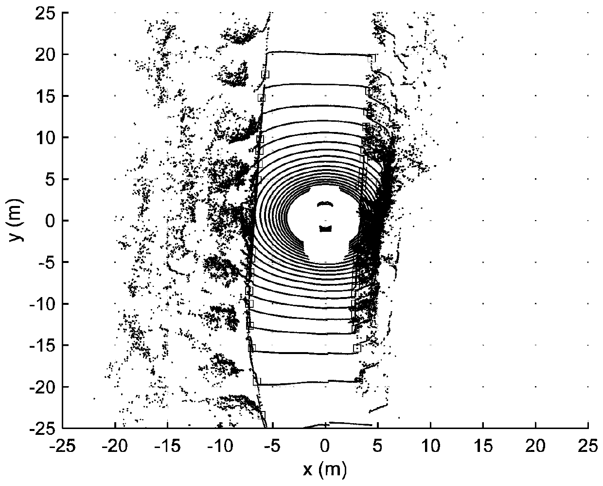
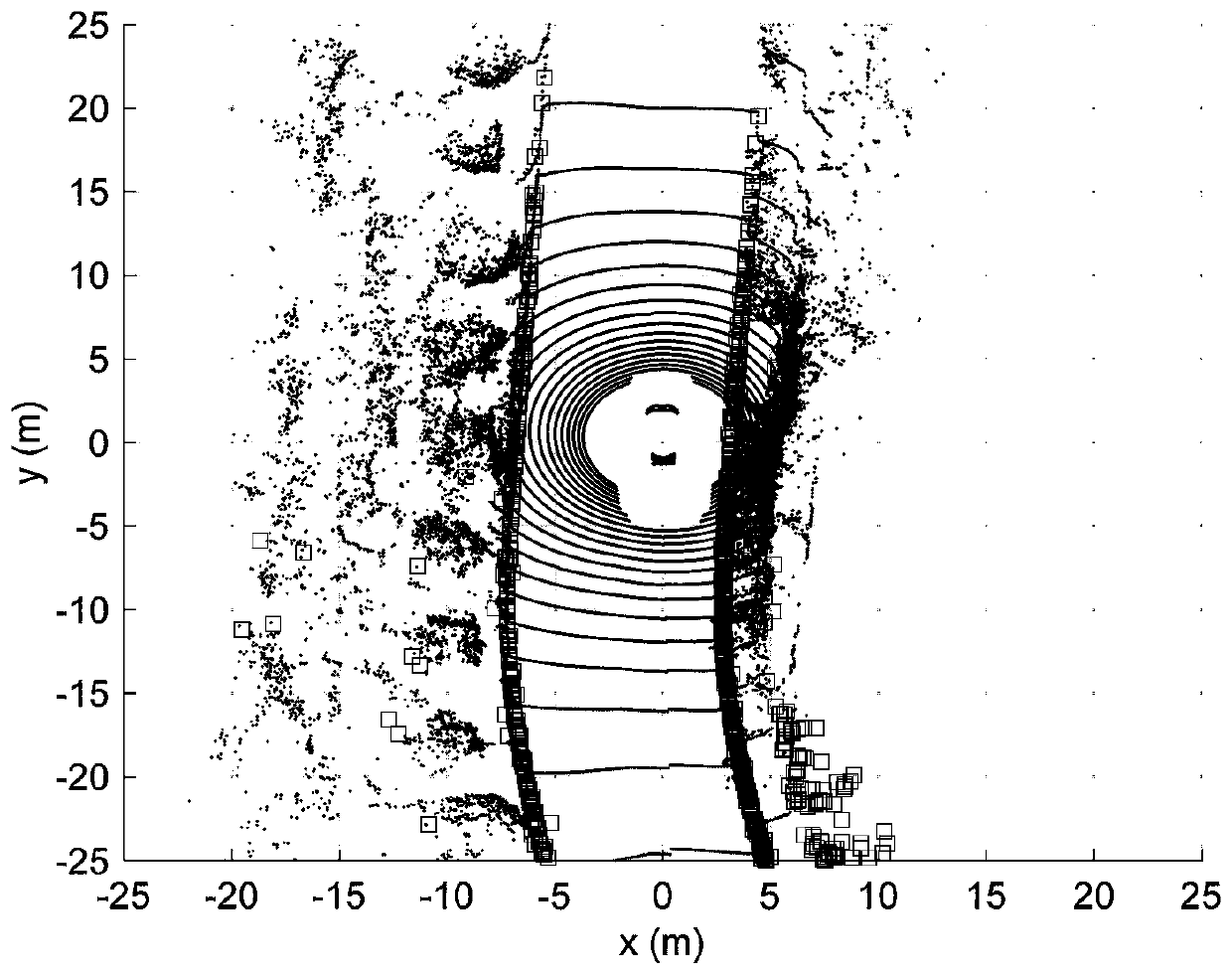
[0035] A real-time positioning method for unmanned vehicles based on laser reflection intensity. This method first extracts the characteristics of laser reflection intensity from single-frame laser point cloud data, and converts the coordinates of roadside feature points detected by multiple frames according to the vehicle kinematics model. Go to the current unmanned vehicle coordinate system, and then use the regional probability matching search algorithm to match the reflection intensity distribution with the reflection intensity distribution in the high-precision map, and calculate the lateral, longitudinal and heading angle deviations of the current unmanned vehicle as observation values , input to the Kalman filter for pose estimation. This embodiment is innovative and practical, can realize real-time precise positioning in a complex environment, and can effectively improve the driving safety of unmanned vehicles.

[0036] Specific steps are as follows:

[0037] 1. Roads...


PUM


Abstract

The invention relates to an unmanned vehicle real-time positioning method based on laser reflection strength. The method comprises the following steps of S1, photographing two sides of a city road by an on-vehicle laser radar, obtaining a plurality of frames of point cloud data, extracting road edge points and converting the road edge points into a current vehicle coordinate system; S2, selecting the road edge points of which the z-axis coordinate value is in a preset range and obtaining coordinates of the road edge points in a GPS coordinate system, using the current GPS coordinate point of the unmanned vehicle as an original point, dividing a coordinate space for obtaining a grid map; S3, matching the gridded high-precision map with the grid map which is obtained in the step S2, thereby obtaining position of the unmanned vehicle on a high-precision map; and S4, predicating vehicle posture by means of a Kalman filter. Compared with prior art, the unmanned vehicle real-time positioning method can realize real-time accurate positioning in a complicated environment and can effectively improve driving safety of the unmanned aerial vehicle.

Description

technical field [0001] The invention relates to a real-time positioning method for an unmanned vehicle, in particular to a real-time positioning method for an unmanned vehicle based on laser reflection intensity. Background technique [0002] With the development of computer technology and artificial intelligence, unmanned vehicles (hereinafter referred to as unmanned vehicles) have shown great application prospects in military, transportation, industrial production, logistics and warehousing, and daily life. In terms of national defense and military affairs, unmanned vehicles are mostly used to perform military tasks in dangerous scenarios, such as military rescue and material delivery. In terms of traffic safety, unmanned driving technology is an effective means to promote the development of intelligent transportation systems. Unmanned driving technology based on artificial intelligence can improve the active safety of vehicles, and can effectively reduce traffic accidents...

Claims


Application Information

Patent Timeline
Patent Type & Authority Patents(China)
IPC IPC(8): G01S7/48
Inventor 王晓年王峻王亮张怡欢
Owner TONGJI UNIV
Why Eureka
Try Eureka