GIS-based X wave band areal rainfall radar data extraction method

An extraction method and technology of radar data, applied in structured data retrieval, rainfall/precipitation gauge, electrical digital data processing, etc., can solve the problem that surface relationship cannot be completely matched

Inactive Publication Date: 2017-06-30
NANJING AUTOMATION INST OF WATER CONSERVANCY & HYDROLOGY MINIST OF WATER RESOURCES +1
View PDF3 Cites 10 Cited by
  • Summary
  • Abstract
  • Description
  • Claims
  • Application Information

AI Technical Summary

Problems solved by technology

[0002] The X-band area rainfall radar rain measurement system can solve the problem that the current discrete rainfall station network cannot completely match the relatio

Method used


Image

  • GIS-based X wave band areal rainfall radar data extraction method
  • GIS-based X wave band areal rainfall radar data extraction method
  • GIS-based X wave band areal rainfall radar data extraction method

Examples


Embodiment Construction

[0031] The technical solutions provided by the present invention will be described in detail below in conjunction with specific examples. It should be understood that the following specific embodiments are only used to illustrate the present invention and are not intended to limit the scope of the present invention.

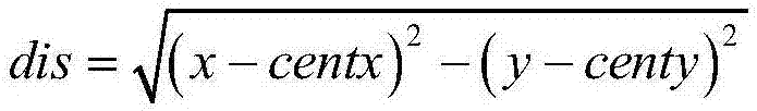
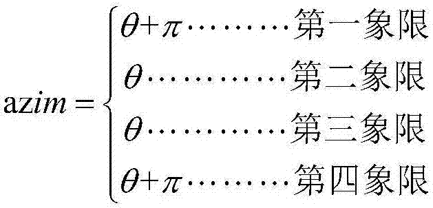
[0032] The GIS-based X-band surface rainfall radar data extraction method proposed by the present invention comprises the following steps:

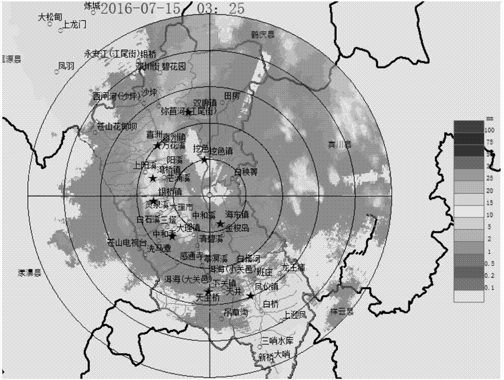
[0033] Step 1, data storage

[0034] The X-band rain radar data has a rigorous data structure and temporal-spatial sequence, which includes two parts: the file header and the rain intensity data. The file header data length is 256 bytes, including information such as data identification, data version number, radar site and detection parameters, and all reserved bytes are filled with 0.

[0035] Table 1 lists the data structure of the file header data.

[0036]

[0037] Table 1 File Header Data Structure

[0038] The st...


PUM


Abstract

The invention discloses a GIS-based X wave band areal rainfall radar data extraction method which comprises a step of data storage, a step of converting polar coordinate data into raster data, a step of radar rainfall image display and a step of radar rainfall data extraction. Via the GIS-based X wave band areal rainfall radar data extraction method, radar data of polar coordinate projection is converted into grid space data, radar polar coordinate data can be converted into and displayed as areal rainfall data, rainfall values can extracted based on given points and faces, and a data source can be provided for a next step of accurate hydrological analysis; a foundation is laid for applying radar rainfall to routine hydrologic rainfall monitoring, urban flood disaster mitigation, middle and small river basin mountain torrent and mud-rock flow early warning and water resource management.

Description

technical field [0001] The invention belongs to the technical field of radar data analysis and processing, and in particular relates to a GIS-based X-band surface rainfall radar data extraction method. Background technique [0002] The X-band area rainfall radar rain measurement system can solve the problem that the relationship between rainfall monitoring data points and areas in the current discrete rainfall station network cannot be completely matched. However, the current hydrological professional field still lacks a relatively complete weather radar monitoring system. Therefore, how to integrate radar data into the existing hydrological monitoring platform to form a hydrological resource monitoring system integrating space and ground has become an urgent problem to be solved. Among them, how to scientifically and completely extract radar data is a key problem. Contents of the invention [0003] In order to solve the above problems, the present invention discloses a m...

Claims


Application Information

Patent Timeline
IPC IPC(8): G01S13/95G01W1/14G06F17/30
CPCG01S13/95G01W1/14G06F16/29Y02A10/40Y02A50/00Y02A90/10
Inventor 牛睿平李辉唐跃平张永兵杜红娟王岩
Owner NANJING AUTOMATION INST OF WATER CONSERVANCY & HYDROLOGY MINIST OF WATER RESOURCES
Why Eureka
Try Eureka