Delaunay-triangulation-network-based multi-redundancy network RTK atmospheric error interpolation method

An atmospheric error and triangulation technology, applied in the field of global navigation satellite system GNSS satellite positioning, can solve problems such as low tropospheric interpolation accuracy, inability to make full use of redundant base stations around users, and inability to perform completeness checks.

Active Publication Date: 2017-07-21
SOUTHEAST UNIV
View PDF4 Cites 31 Cited by
  • Summary
  • Abstract
  • Description
  • Claims
  • Application Information

AI Technical Summary

Problems solved by technology

[0004] Purpose of the invention: In order to overcome the deficiencies in the prior art, the present invention provides a multi-redundant network RTK atmospheric error interpolation method based on Delaunay triangulation, which can solve th

Method used


Image

  • Delaunay-triangulation-network-based multi-redundancy network RTK atmospheric error interpolation method
  • Delaunay-triangulation-network-based multi-redundancy network RTK atmospheric error interpolation method
  • Delaunay-triangulation-network-based multi-redundancy network RTK atmospheric error interpolation method

Examples


Embodiment

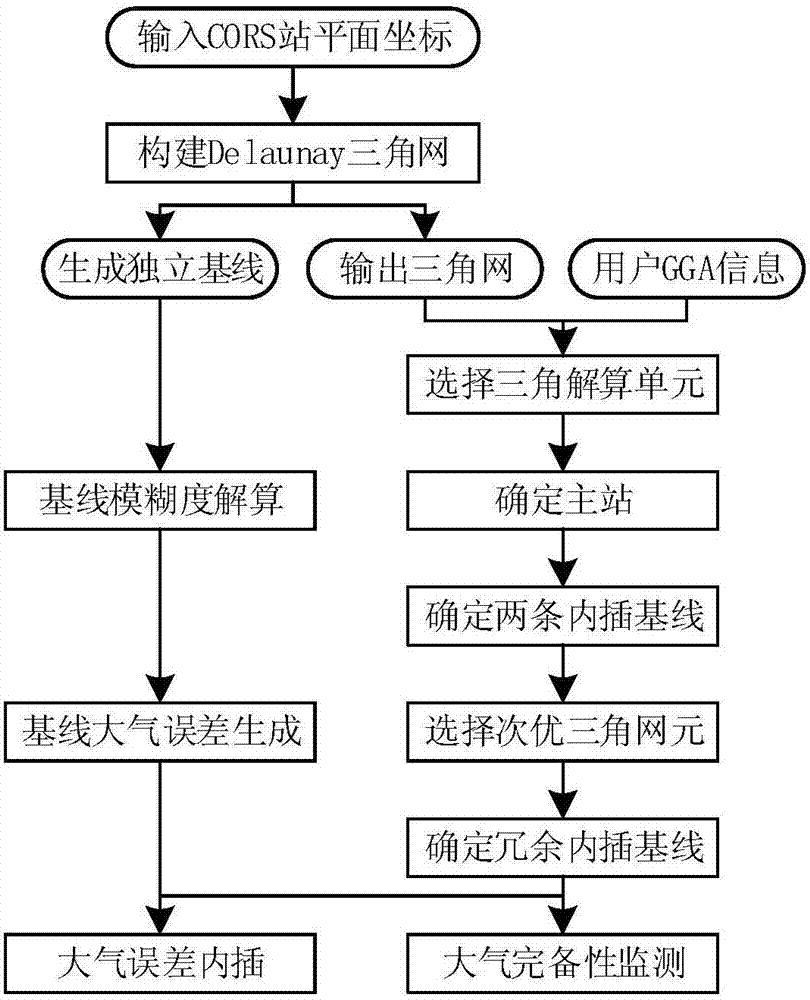
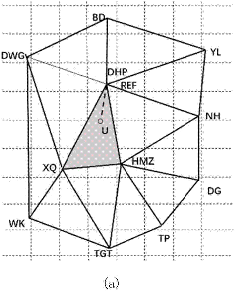
[0085] Example: such as Figure 6 The reference station network diagram shown is based on the GPS observation data of 6 stations, P343, P165, P322, P332, P345, and P349 on August 08, 2013, with a sampling rate of 15s on the CORS network of the United States. Ionosphere, troposphere interpolation accuracy analysis and atmospheric completeness analysis. During the test, the G19 satellite whose altitude angle has two rising and falling processes is selected for comparative analysis. use Figure 9-10 A comparative analysis diagram of the ionosphere and troposphere interpolation inside and outside the grid is given.

[0086] In the network experiment, the base station P343 is the main station, and the base station P332 is the monitoring station. Conventional interpolation experiments use base stations P322 and P345 as interpolation stations, and redundant triangular interpolation experiments use base stations P165, P322, P345, and P349 as interpolation base stations. Figure 9 ...


PUM


Abstract

The invention discloses a delaunay-triangulation-network-based multi-redundancy network RTK atmospheric error interpolation method. A network RTK data processing center constructs a Delaunay triangulation network based on a correct coordinate of a CORS base station; after a user is accessed to a data processing center, an optimal triangular unit and a suboptimum triangular unit of the location of the user are selected; an atmospheric error interpolation base line number is extended; an MLIM ionized layer interpolation model and an RELIM tropospheric interpolation model are established; and an atmospheric interpolation completeness monitoring method of a moving station in a grid is provided. The interpolation precision of the MLIM ionized layer interpolation model is higher than that of the traditional model by three times and the interpolation precision of the RELIM tropospheric interpolation model is higher than that of the traditional model by 6 to 30 times; and the two models can still have high interpolation precision at an area with a large elevation difference at the base station. A regional CORS ionized layer and tropospheric completeness index can reach a centimetre-level interpolation precision, so that real-time positioning completeness monitoring of a network RTK user can be realized. With the method provided by the invention, a CORS base station around a user can be utilized fully; the atmospheric delay interpolation precision of the area can be improved; and the rapid and high-precision positioning of the user can be guaranteed.

Description

technical field [0001] The present invention relates to the field of global navigation satellite system GNSS (Global Navigation System) satellite positioning, in particular to network RTK (Real-Time Kinematic) atmospheric error interpolation and completeness monitoring based on ground-based augmentation system, which is the research of GNSS real-time high-precision RTK positioning technology important parts of. Background technique [0002] The continuous improvement of the Global Navigation System (GNSS) and the integration of satellite navigation and Internet technology have greatly expanded the depth and breadth of the application of high-precision satellite positioning technology. Network RTK technology represented by virtual reference station technology VRS (virtual reference station) can provide centimeter-level positioning accuracy, effectively promoting the wide application of satellite navigation systems, and various industries have more stringent requirements for p...

Claims


Application Information

Patent Timeline
IPC IPC(8): G01S19/43G01S19/40
CPCG01S19/40G01S19/43
Inventor 高成发尚睿潘树国汪登辉
Owner SOUTHEAST UNIV
Why Eureka
Try Eureka