Beidou meo satellite signal fitting method based on least squares and gradient descent method

A technique of gradient descent method and least square method, which is applied in the field of satellite navigation, can solve problems such as the inability to obtain high-precision solution results, and achieve the effect of guaranteeing calculation results

Active Publication Date: 2019-09-24
金华航大北斗应用技术有限公司
View PDF5 Cites 0 Cited by
  • Summary
  • Abstract
  • Description
  • Claims
  • Application Information

AI Technical Summary

Problems solved by technology

Simple statistical calculations or difference calculations cannot obtain high-precision solution results, and even negative amplitudes that do not conform to common sense in physics

Method used


Image

  • Beidou meo satellite signal fitting method based on least squares and gradient descent method
  • Beidou meo satellite signal fitting method based on least squares and gradient descent method
  • Beidou meo satellite signal fitting method based on least squares and gradient descent method

Examples


Embodiment 1

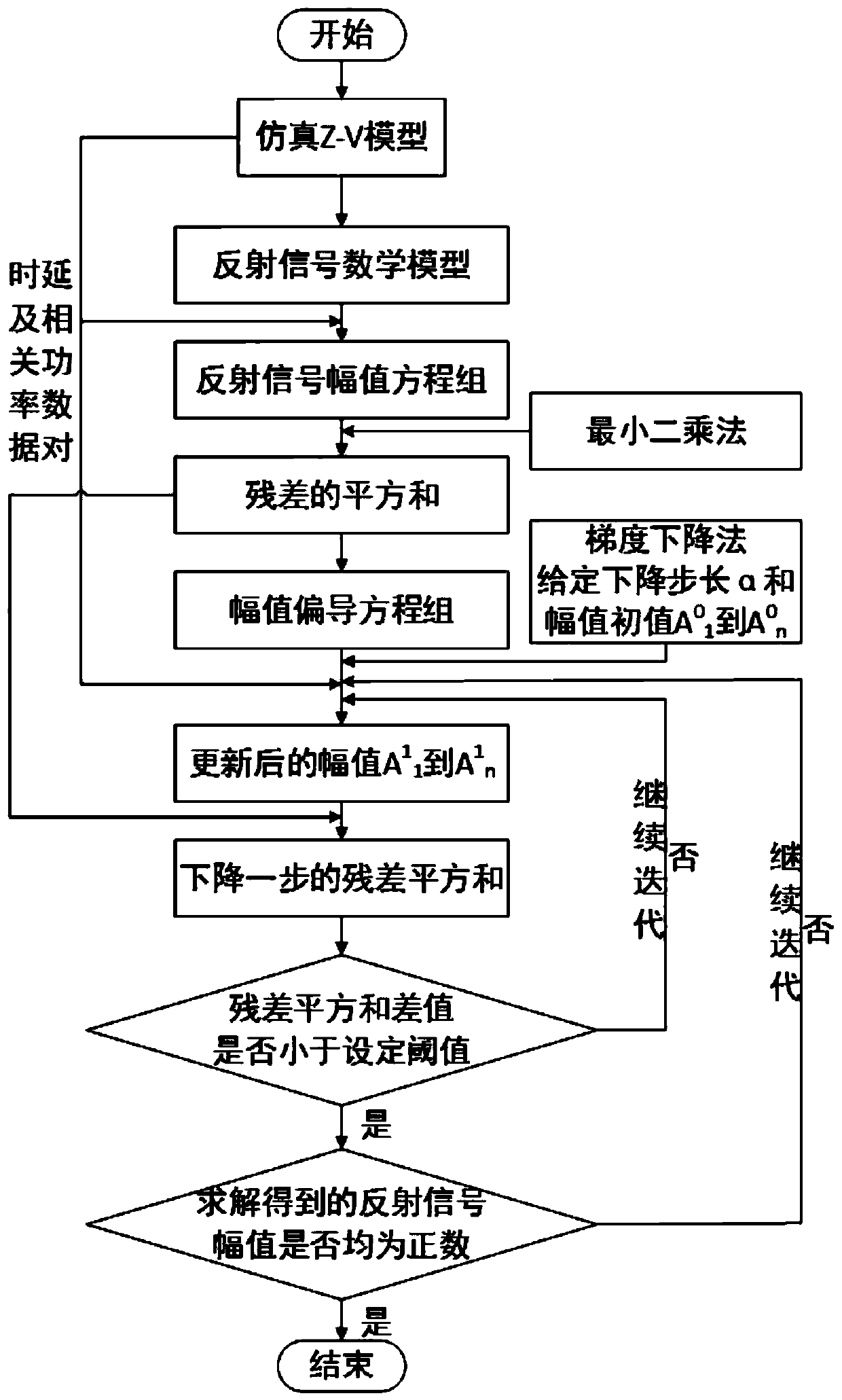
[0055] The present invention provides a Beidou MEO satellite signal fitting method based on least squares and gradient descent, such as figure 1 As shown, the fitting method includes:

[0056] Step 1. Simulation based on Z-V model, including:

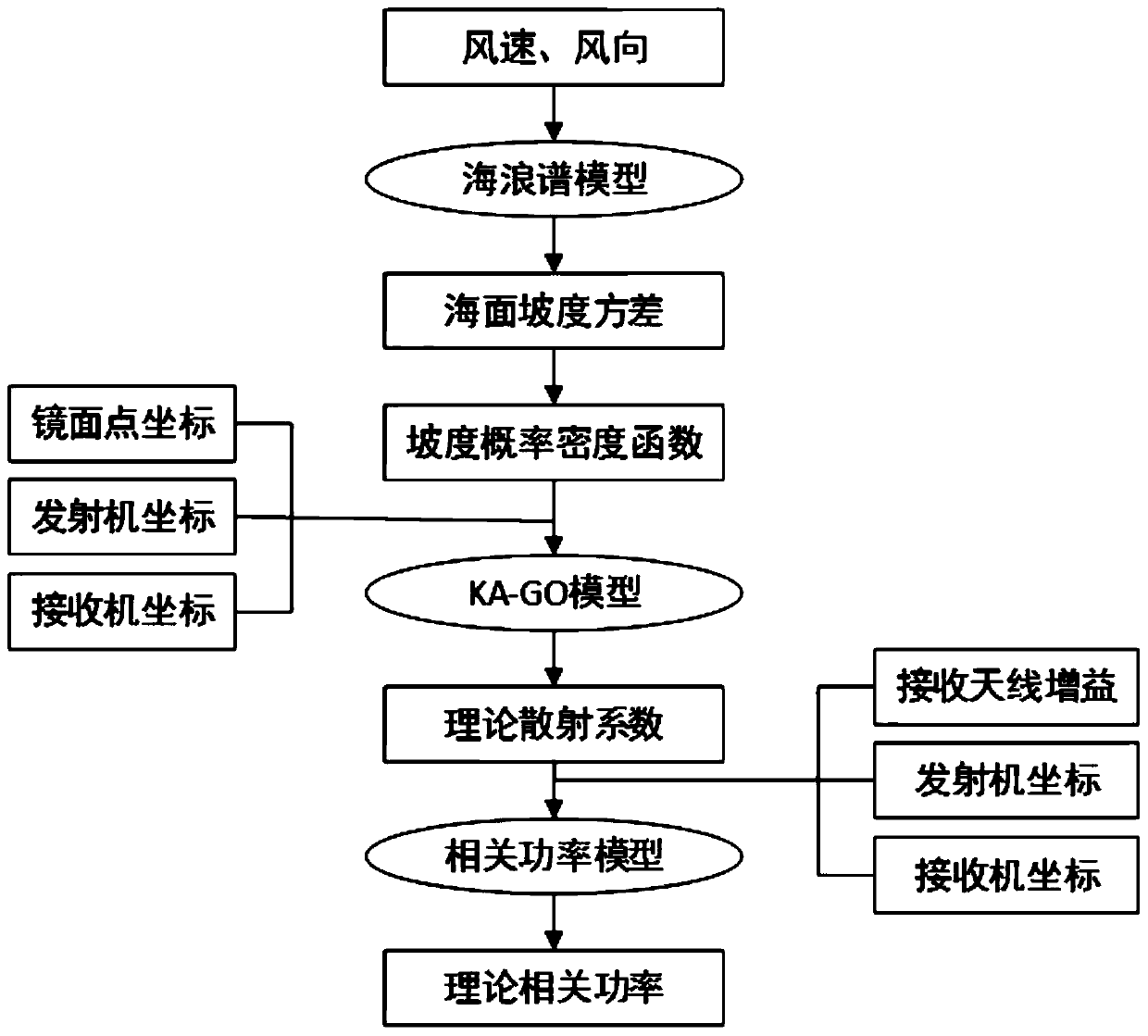
[0057] Using Elfouhaily wave spectrum, KA-GO scattering model, and Z-V model formula:

[0058]

[0059] In formula (1), R 0 Represents the distance from the satellite to the scattering point, R represents the distance from the receiver to the scattering point; T i Represents the coherent integration time; D represents the gain of the receiver antenna; Λ is the autocorrelation function of the PRN code; S is the Doppler filter function; σ 0 Is the standardized scattering cross section of rough sea surface; Represents the vector from the mirror point to a certain point on the average sea surface;

[0060] Then the general process of calculating the theoretical related power is as follows figure 2 . By configuring parameters such as wind directio...


PUM


Abstract

The invention provides a Big Dipper MEO (Medium Earth Orbit) satellite signal fitting method based on a least square method and a gradient descent method, and belongs to the field of satellite navigation. The method comprises the steps of simulating based on a Z-V model, building a reflected signal mathematical model, building an equation set in regard to a reflected signal amplitude, building a partial derivative equation set by utilizing the least square method, adopting the gradient descent method for finding an optimal solution, and limiting a condition control result to be positive. A quadratic sum of residual errors of the equation set is obtained according to the principle of the nonlinear least square method, the optimal solution is found in an iteration way according to the principle of the gradient descent method, a descent step length is given, an initial value is set, a value is obtained after one iteration, repeated iteration is carried out, the descent is stopped after z times of descent and when a difference value is smaller than a preset threshold value, and at the time, the quadratic sum of the residual errors is the least, so that the result is the required amplitude. Through setting a limiting condition and threshold value control, the high-accuracy result can be obtained, and meanwhile, a calculation result is ensured to be non-negative.

Description

Technical field [0001] The invention belongs to the field of satellite navigation, and particularly relates to a Beidou MEO satellite signal fitting method based on the least squares and gradient descent method. Background technique [0002] GNSS-R (Global Navigation Satellite System-Reflections) technology is a new branch of GNSS technology developed since 1997. It is one of the research hotspots in the field of remote sensing, telemetry and navigation and positioning at home and abroad. It uses the reflected signals of navigation satellites to remotely sense the sea surface to extract the physical characteristics of the target reflection surface or to detect moving targets. It can obtain effective wave height, tide level, sea surface wind speed and wind direction and other parameters. It is widely used in sea surface wind measurement and sea surface height measurement. , Sea ice detection, sea salt detection, sea surface oil spill, soil moisture and other fields. Compared with...

Claims


Application Information

Patent Timeline
Patent Type & Authority Patents(China)
IPC IPC(8): G01S19/37
Inventor 不公告发明人
Owner 金华航大北斗应用技术有限公司
Why Eureka
Try Eureka