Integrated navigation system based on GGI/GPS/INS

An integrated navigation system and strapdown navigation technology, applied in the field of integrated navigation systems based on GGI/GPS/INS, can solve the problems of large positioning errors, low self-precision, and inability to locate, so as to improve accuracy, strengthen engineering application value, Effect of Accuracy Improvement

Inactive Publication Date: 2017-08-08
CHONGQING UNIV OF POSTS & TELECOMM
View PDF4 Cites 10 Cited by
  • Summary
  • Abstract
  • Description
  • Claims
  • Application Information

AI Technical Summary

Problems solved by technology

Existing navigation systems and integrated navigation systems generally have shortcomings such as large size, difficulty in integration, and poor accuracy. They are difficult to meet the development needs of micro-miniature systems, and do not meet the urgent needs of military equipment development.
[0003] Traditionally used navigation systems (such as GPS navigation system, INS navigation system and astronomical navigation system, etc.) and integrated navigation systems (such as GPS/INS integrated navigation system, astronomical/INS integrated navigation, etc.) Positioning, when the electromagnetic wave signal is weak or even absent, it is impossible to accurately locate objects, such as

Method used


Image

  • Integrated navigation system based on GGI/GPS/INS
  • Integrated navigation system based on GGI/GPS/INS
  • Integrated navigation system based on GGI/GPS/INS

Examples


Embodiment Construction

[0035]The technical solutions in the embodiments of the present invention will be described clearly and in detail below with reference to the drawings in the embodiments of the present invention. The described embodiments are only some of the embodiments of the invention.

[0036] The technical scheme that the present invention solves the above-mentioned technical problem is,

[0037] The technical scheme of the present invention will be described in detail below in conjunction with accompanying drawing:

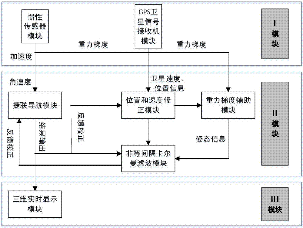
[0038] The combined navigation system of GGI / GPS / INS of the present invention is as figure 1 shown. The system consists of a sensor module, an integrated navigation solution module and a real-time display module.

[0039] The sensor module includes an inertial sensor module and a GPS satellite signal receiver module; the combined navigation calculation module includes a strapdown navigation module, a gravity gradient auxiliary module, a non-equal interval Kalman filter mo...


PUM


Abstract

The invention discloses an integrated navigation system based on GGI/GPS/INS. The system is composed of a sensor module, an integrated navigation resolving module and a real-time displaying module and is characterized in that the sensor module comprises an inertial sensor module and a GPS satellite signal receiver module, the integrated navigation resolving module comprises strapdown navigation module, a gravity gradient auxiliary module, an unequal-interval kalman filtering module and a position and speed correcting module, and the real-time displaying module is formed by a three-dimensional real-time display module. The integrated navigation system disclosed by the invention can improve locating precision, and the locating precision is hardly affected by environmental change.

Description

technical field [0001] The invention belongs to the technical field of integrated navigation, and in particular relates to an integrated navigation system based on GGI / GPS / INS. Background technique [0002] At present, the navigation system has penetrated into the daily life, and there are more and more fields where the system is applied. Our country has also invested a lot of manpower and material resources in research, and it has broad application prospects in aerospace, transportation, safety and fire protection and other fields. Existing navigation systems and integrated navigation systems generally have shortcomings such as large size, difficulty in integration, and poor accuracy. [0003] Traditionally used navigation systems (such as GPS navigation system, INS navigation system and astronomical navigation system, etc.) and integrated navigation systems (such as GPS / INS integrated navigation system, astronomical / INS integrated navigation, etc.) Positioning, when the e...

Claims


Application Information

Patent Timeline
IPC IPC(8): G01C21/00G01C21/16G01S19/48
CPCG01C21/00G01C21/165G01S19/48
Inventor 胡远林吴英冬叶盛惠鸿飞罗康岚路永乐陈思桥
Owner CHONGQING UNIV OF POSTS & TELECOMM
Why Eureka
Try Eureka