Indoor location and navigation method based on built-in inertial sensor of smart phone

A technology of inertial sensors and smartphones, which is applied in navigation, surveying and mapping, and navigation calculation tools, etc. It can solve the problems of difficult large-scale indoor coverage, high positioning costs, and unsupported mobile phones, and achieves wide application range and accurate direction calculation. Smart, labor-saving and cost-saving effects

Inactive Publication Date: 2017-08-11
SOUTH CHINA UNIV OF TECH
View PDF7 Cites 21 Cited by
  • Summary
  • Abstract
  • Description
  • Claims
  • Application Information

AI Technical Summary

Problems solved by technology

However, UWB is difficult to achieve large-scale indoor coverage, and mobile phones do not support UWB, so the positioning cost is very high

Method used


Image

  • Indoor location and navigation method based on built-in inertial sensor of smart phone
  • Indoor location and navigation method based on built-in inertial sensor of smart phone
  • Indoor location and navigation method based on built-in inertial sensor of smart phone

Examples


Embodiment

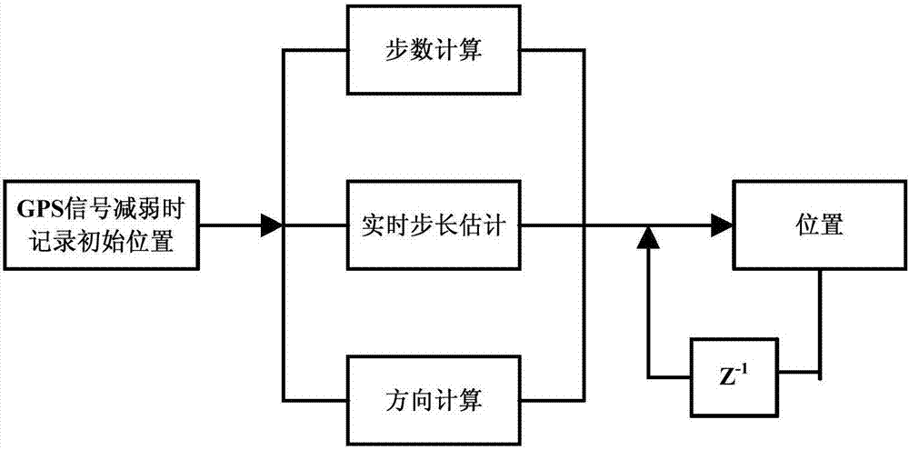
[0048] Such as figure 1 As shown, this embodiment provides a method for indoor positioning and navigation based on the built-in inertial sensor of a smart phone, and the method includes the following steps:

[0049] Step 1. Record the received accurate GPS positioning signal, and use the accurate GPS positioning signal as the initial position for positioning;

[0050] Step 2. After the GPS signal weakens or even disappears, use the sensor that comes with the mobile phone to record the distance and direction of the person in real time, so as to calculate the displacement of the person on the horizontal plane;

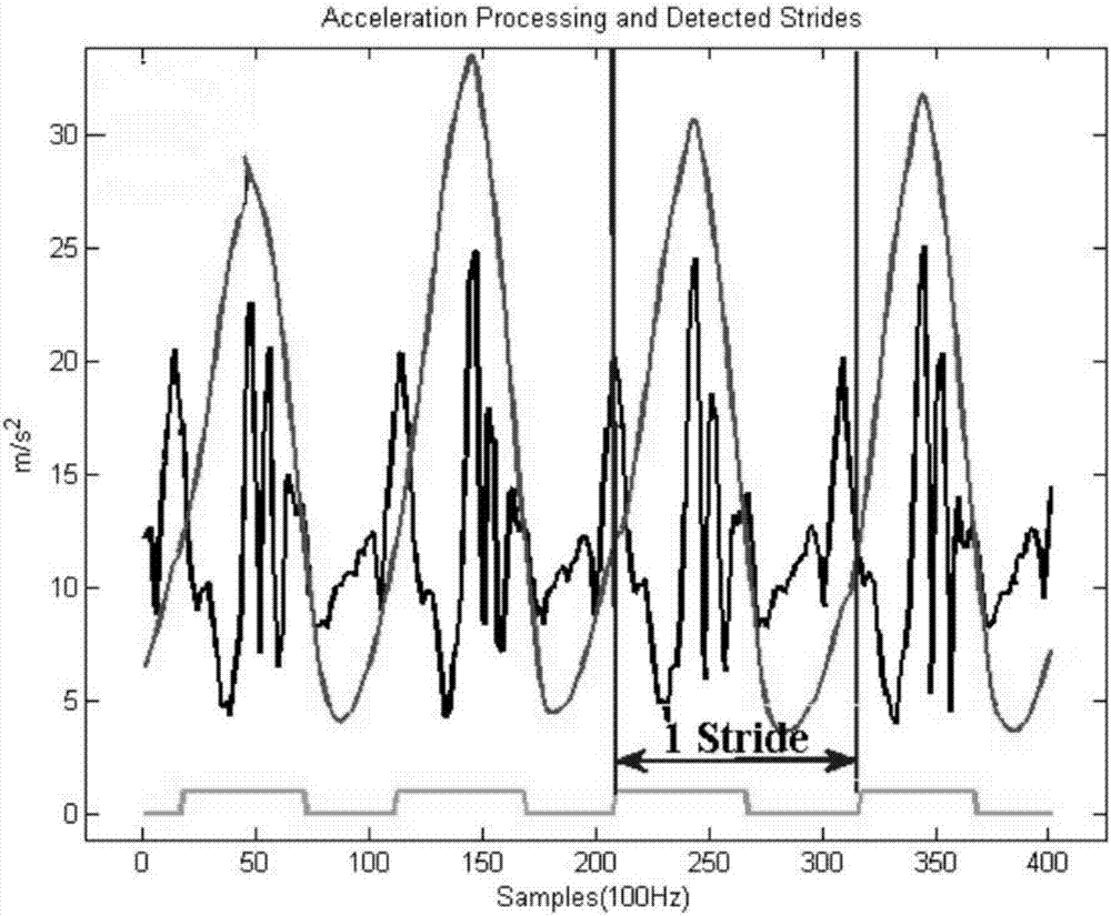
[0051] In this step, the distance traveled by the person is obtained by using the footstep detection algorithm to judge the situation of the person's walking by analyzing the change of the acceleration, which specifically includes two parts:

[0052] The first part, the calculation of the number of steps, the specific steps are:

[0053] 1. Calculate the combined accel...


PUM


Abstract

The invention discloses an indoor location and navigation method based on a built-in inertial sensor of a smart phone. The method includes the following steps of, firstly, recording received precise GPS (global positioning system) signals, and taking the precise GPS signals as an initial locating position; secondly, when the GPS signals go weakened or disappear, recording travelling distance and direction of a user through the built-in sensor of the smart phone to calculate the displacement of the user on a horizontal plane; thirdly, according to the calculating result of a current moment and the position information of a previous moment in the second step, obtain current position information, and according to the position information of every 2 seconds, drawing a traveling route. Compared with other indoor navigation schemes, the indoor localization and navigation method based on the built-in inertial sensor of the smart phone only requires one smart phone without dependence on peripheral equipment and has the advantages of being high in precision, low in cost and easy to implement.

Description

technical field [0001] The invention relates to the field of indoor navigation of mobile phones, in particular to an indoor positioning and navigation method based on built-in inertial sensors of smart phones. Background technique [0002] With the development of the economy, exhibitions, shopping malls, parking lots, scenic spots, museums and other venues are becoming larger and larger, with hundreds of thousands or even millions of square kilometers everywhere. In such a large place, it is sometimes difficult to find a specific merchant or location, so indoor navigation was born. Indoor navigation allows consumers in places such as large department stores to use the precise positioning function to determine their location and find the place they want to go even in the building. You can use indoor navigation to easily find designated places for some large buildings. Places, such as parking spaces, ATMs and designated businesses, etc. [0003] At present, the existing posi...

Claims


Application Information

Patent Timeline
Patent Type & Authority Applications(China)
IPC IPC(8): G01C21/16G01C21/20
CPCG01C21/206G01C21/165
Inventor 柴光南薛洋梁又凡张锟王子禛
Owner SOUTH CHINA UNIV OF TECH
Why Eureka
Try Eureka