Dual linear polarization radar system and measurement method for strong rain

A radar system, dual linear polarization technology, applied in radio wave measurement systems, measurement devices, reflection/re-radiation of radio waves, etc. Insufficient coordination ability and other problems, to achieve wide applicability and practicability, overcome the effect of small monitoring range

Pending Publication Date: 2017-08-18
泰州飞帆船舶科技有限公司
View PDF0 Cites 17 Cited by
  • Summary
  • Abstract
  • Description
  • Claims
  • Application Information

AI Technical Summary

Problems solved by technology

The main performance is that the vertical resolution of the middle and low layers is relatively low. In mountainous areas, especially in mountainous areas, radar stations adopt volume scanning mode, which results in a small monitoring range of the atmospheric boundary layer, blurred dis

Method used


Image

  • Dual linear polarization radar system and measurement method for strong rain
  • Dual linear polarization radar system and measurement method for strong rain
  • Dual linear polarization radar system and measurement method for strong rain

Examples


Embodiment Construction

[0022] The content of the present invention will be further described below with reference to the accompanying drawings.

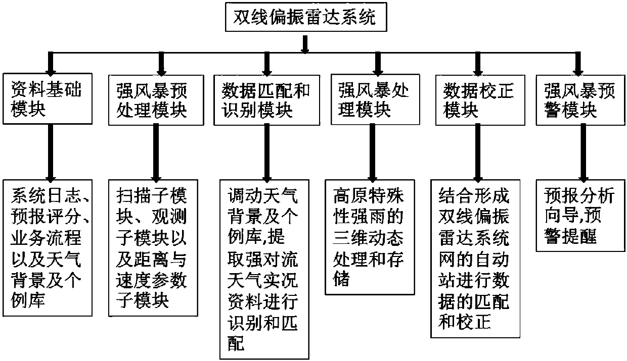
[0023] like figure 1 As shown in the figure, a dual linear polarization radar system uses a satellite navigation system with an efficient communication network adapted to the weather radar network, and uses a radar network to achieve time and space synchronization and refined structure for a large-scale or a specific area weather system. collaborative observation. Combining high-resolution GIS information with collaborative observation, it realizes the time-space and quantitative consistency of networked radar observations, and improves the ability to monitor and warn against severe weather such as heavy rain. The dual linear polarization radar system includes a data base module, a strong storm preprocessing module, a data matching and identification module, a strong storm processing module, a data correction module and a strong storm early warning module...


PUM


Abstract

The invention discloses a dual linear polarization radar system. The dual linear polarization radar system comprise a data base module, a strong storm preprocessing module, a data matching and identification module, a strong storm processing module, a data correction module and a strong storm early-warning module. Time and space synchronization of a large-scale or specific-region weather system and collaborative observation of a fine structure are achieved by utilizing an efficient communication network application satellite navigation system adaptive to a weather radar network through an application of radar networking. High-definition GIS information and the collaborative observation are combined, quantitative time and space consistency of networking radar observation is achieved, and abilities to monitor and early warn disastrous weather such as strong rain are improved. The invention further provides a corresponding measurement method for the strong rain on a plateau by utilizing a dual linear polarization radar system network.

Description

Technical field: [0001] The invention relates to a dual linear polarization radar system and a method for measuring heavy rainfall on plateaus by using the dual linear polarization radar system network. Background technique: [0002] The Qinghai-Tibet Plateau accounts for about 1 / 4 of my country's land area, with an average altitude of more than 4km. It is the highest plateau with the most complex terrain in the world, and is known as the roof of the world. The unique topographical conditions of the Qinghai-Tibet Plateau make it different from the weather characteristics of plain areas and general mountains. In the 1970s and 1990s, my country organized two large-scale field scientific experiments on the Qinghai-Tibet Plateau, and achieved very important results. The circulation characteristics, weather system, heat source properties, plateau monsoon and South Asian high in the plateau region were studied in depth, and many new facts were revealed, which laid an important fo...

Claims


Application Information

Patent Timeline
IPC IPC(8): G01S13/95G01W1/10
CPCG01S13/95G01W1/10Y02A90/10
Inventor 申重阳
Owner 泰州飞帆船舶科技有限公司
Why Eureka
Try Eureka