Fire fighting positioning method combining drone and ultra wide band radar

A technology of ultra-wideband radar and positioning method, applied in the direction of radio wave measurement system, radio wave reflection/re-radiation, utilization of re-radiation, etc., to achieve the effect of facilitating on-site command

Inactive Publication Date: 2017-08-22
江苏智绘空天技术研究院有限公司
View PDF8 Cites 9 Cited by
  • Summary
  • Abstract
  • Description
  • Claims
  • Application Information

AI Technical Summary

Problems solved by technology

[0008] Technical problem: The purpose of the present invention is to provide a UWB radar fire-fighting positioning method, which combines the UWB radar indoor positioning system with technologies such as UAV, microwave radiometer, and infrared imaging, aiming at solving the problem of any Indoor positioning system at the fire scene, the problem of being able to extract fire information

Method used


Image

  • Fire fighting positioning method combining drone and ultra wide band radar
  • Fire fighting positioning method combining drone and ultra wide band radar
  • Fire fighting positioning method combining drone and ultra wide band radar

Examples


Embodiment Construction

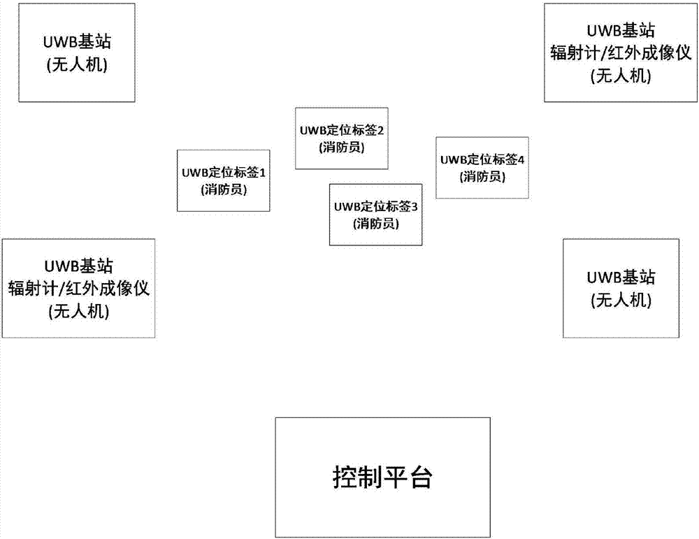
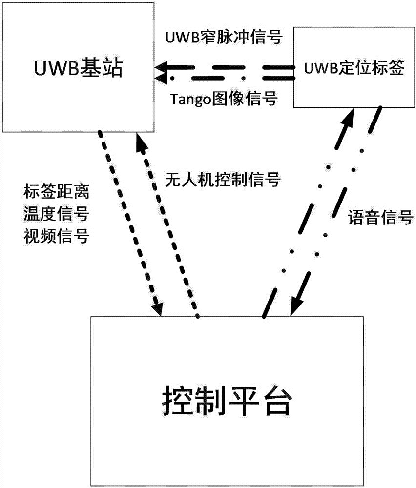
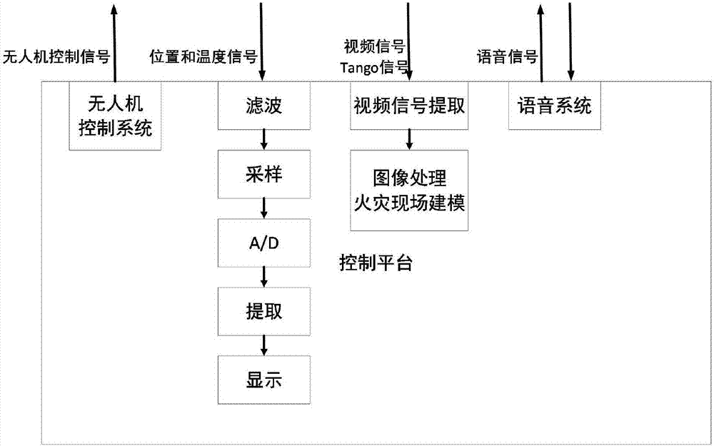
[0026] A kind of UAV-borne UWB radar fire-fighting positioning method of the present invention is characterized in that, described positioning method is as follows:

[0027] The positioning tag sends a wireless extremely narrow pulse signal to the ultra-wideband radar base station. The ultra-wideband radar base station calculates the distance from the tag to the base station according to the time when the pulse signal sent by different positioning tags arrives at the ultra-wideband radar base station at different locations, and sends it to the control station through ZigBee technology. On the platform, the control platform filters, samples, A / D and extracts the received positioning signal, calculates the final distance information, and finally obtains the position of the tag, and displays it on the console screen;

[0028] The microwave radiometer adopts passive measurement technology, and the infrared thermal imager measures the surface temperature of objects at the fire scene...


PUM


Abstract

The invention provides a fire fighting positioning method combining a drone and ultra wide band radar. The method comprises steps that a positioning tag sends a wireless narrow pulse signal to an ultra wide band radar base station; a microwave radiometer adopts the passive measurement technology; an infrared thermal imager measures surface temperature of objects in a fire disaster place and sends temperature signal of the fire disaster place to a control platform; a video monitoring system extracts video signals of the fire disaster place and sends the video signal to the control platform; a real-time onsite image acquisition system based on the Tango technology sends the signals to the control platform; and the control platform receives position information, the temperature information and the video signals from a base station, sends a control signal for controlling postures of the drone to the base station so as to process positioning information in real time, extract fire information, video signals and real time images extracted through the Tango technology and control the postures of the drone. According to the invention, the method can be applied to an indoor positioning system of any fire disaster place and used for extracting fire information.

Description

technical field [0001] The invention relates to the field of positioning technology, in particular to a positioning method applied in the field of fire protection that combines unmanned aerial vehicle, microwave radiometer, infrared imager, Tango technology and ultra-wideband radar. Background technique [0002] In recent years, with the rapid development of short-range radio technology and the advancement of wireless local area network technology, indoor positioning technology has advanced by leaps and bounds. Outdoors, GPS and Beidou can provide very accurate positioning information. At the same time, people's demand for indoor positioning information is also increasing day by day, such as airports, exhibitions, office buildings, underground parking lots, security monitoring, military training, logistics management and The field of fire protection requires the use of accurate indoor positioning information. [0003] Several wireless technologies exist for indoor positioni...

Claims


Application Information

Patent Timeline
Patent Type & Authority Applications(China)
IPC IPC(8): G01S13/42
Inventor 黄莹珠徐忠建朱必亮
Owner 江苏智绘空天技术研究院有限公司
Why Eureka
Try Eureka