In-orbit high-precision real-time positioning method based on optical images

A real-time positioning and optical imaging technology, applied in the field of optical satellite remote sensing images, can solve the problems of reduced positioning accuracy, inability to meet real-time application requirements, positioning time lag, etc., to reduce time lag, reduce pressure, reduce The effect of improving positioning accuracy

Active Publication Date: 2017-08-22
SHANGHAI SPACEFLIGHT INST OF TT&C & TELECOMM
View PDF7 Cites 10 Cited by
  • Summary
  • Abstract
  • Description
  • Claims
  • Application Information

AI Technical Summary

Problems solved by technology

[0003] When using optical satellite images for tracking and positioning, the positioning accuracy is reduced due to various errors in the system. The traditional positioning technology is to download the image data to the ground, and reduce the system error through the data processing of the ground server, thereby improving positioning. Accuracy; however, data download processing will cause time lag in positioning, which cannot meet the application requirements with high real-time requirements

Method used


Image

  • In-orbit high-precision real-time positioning method based on optical images
  • In-orbit high-precision real-time positioning method based on optical images
  • In-orbit high-precision real-time positioning method based on optical images

Examples


Embodiment Construction

[0030] The present invention will be further described in detail below through specific embodiments in conjunction with the accompanying drawings.

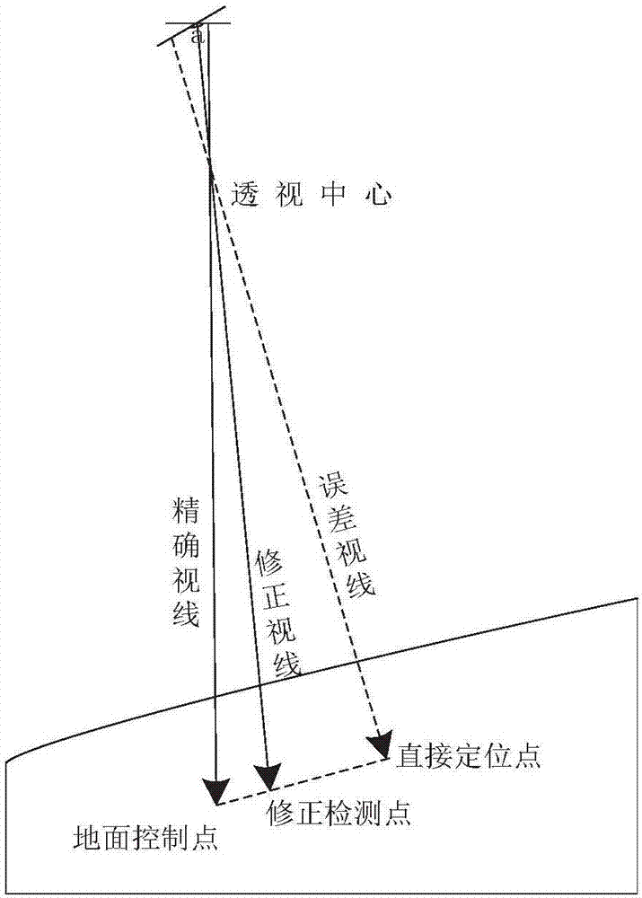
[0031] This example provides an on-orbit high-precision real-time positioning method based on optical images. The schematic diagram of the principle is as follows figure 1 As shown, through the principle analysis, it can be found that there is a one-to-one mapping relationship between optical satellite images and ground objects, so optical satellite images can be used to accurately track and locate ground objects. However, the process of obtaining images with optical loads is A complex process of multiple loads working together, so various systematic errors and random errors will inevitably be introduced. It is precisely because of the existence of these errors that the positioning accuracy is greatly reduced. By correcting the parameters of the on-board geometric positioning model and eliminating systematic errors and some random...


PUM


Abstract

The invention provides an in-orbit high-precision real-time positioning method based on optical images. The in-orbit high-precision real-time positioning method comprises the steps that: relevant parameters in a strict geometric imaging model are classified and equalized, and the strict geometric imaging model is equivalent to an on-satellite geometric positioning model; parameters of the on-satellite geometric positioning model are corrected by utilizing a control point of a ground calibration field; and the corrected parameters are registered to a satellite. Since the traditional strict geometric imaging model is subjected to board division and optimization, the strict geometric imaging model is equivalent to the on-satellite geometric positioning model, the on-satellite geometric positioning model can adapt to the situation of limited on-satellite resources, the time hysteresis of positioning is reduced through real-time positioning treatment by means of the on-satellite geometric positioning model, the pressure on a digital transmission system by massive data downward-transfer is reduced, and finally errors of the system are reduced by adopting a parameter correction method based on satellite-ground collaboration, thereby improving the positioning precision.

Description

technical field [0001] The invention relates to the technical field of optical satellite remote sensing images, in particular to an on-orbit high-precision real-time positioning method based on optical images. Background technique [0002] Although the research on on-orbit high-precision real-time positioning technology is still in its infancy in China, with the massive increase in the data rate of optical satellite remote sensing, it has brought enormous pressure to the data transmission system, and the traditional positioning technology based on ground processing has been difficult to meet. Therefore, the application requirements for on-orbit target recognition and high-precision positioning have become increasingly urgent. On-orbit high-precision positioning calculation technology can provide real-time object position information of detection targets, realize the positioning of moving and static targets, and analyze the trajectory and behavioral intention of moving target...

Claims


Application Information

Patent Timeline
Patent Type & Authority Applications(China)
IPC IPC(8): G06T7/73G06T7/246
CPCG06T2207/10032G06T2207/30241
Inventor 杨培庆谢宝蓉张昳玲何健钟鸣章斌赵传军穆文涛胡玲娜
Owner SHANGHAI SPACEFLIGHT INST OF TT&C & TELECOMM
Why Eureka
Try Eureka