Road water-logging area identification method based on three-dimensional line laser technology

An identification method, a technology for waterlogged areas, applied in special data processing applications, instruments, electrical digital data processing, etc.

Active Publication Date: 2017-08-25
CHANGAN UNIV +1
View PDF7 Cites 15 Cited by
  • Summary
  • Abstract
  • Description
  • Claims
  • Application Information

AI Technical Summary

Problems solved by technology

[0006] The purpose of the present invention is to provide a method for identifying waterlogged areas on roads based on three-dimensional line laser technology, so as to solve the defects in existing milling quality evaluation methods. The impact and harm to traffic and pedestrians when water accumulation occurs

Method used


Image

  • Road water-logging area identification method based on three-dimensional line laser technology
  • Road water-logging area identification method based on three-dimensional line laser technology
  • Road water-logging area identification method based on three-dimensional line laser technology

Examples


Embodiment Construction

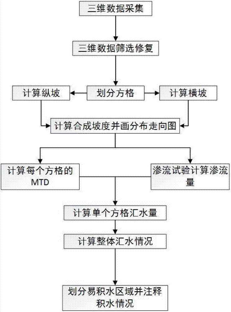
[0056] Below in conjunction with accompanying drawing, the present invention is described in further detail:

[0057] see figure 1 , a three-dimensional laser technology-based identification and evaluation method for water-prone areas on roads, including the following steps:

[0058] The first step: 3D point cloud data collection

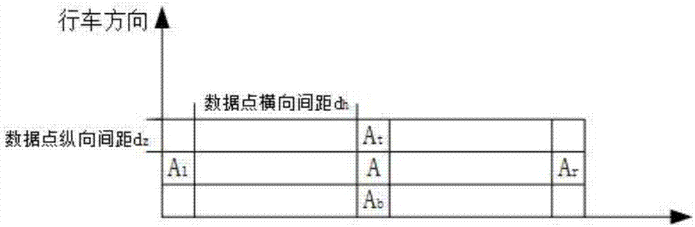
[0059] Select the reference road surface and perform plane calibration. The measured reference road surface is regarded as a reference plane with an elevation of 0. Adjust the parameters of the three-dimensional laser detection equipment, measure and save the position coordinates and elevation data of the road surface with a laser longitudinal spacing of 5mm, and the missing rate of laser point cloud data should be less than 5%.

[0060] Step 2: Data screening and repair

[0061] Outliers and zero-value data were repaired using the four-point averaging method.

[0062] Four-point average method: Take the effective value of the four critical poi...


PUM


Abstract

The invention discloses a road water-logging area identification method based on a three-dimensional line laser technology. The method comprises the following steps that: S1: selecting a benchmark road surface, executing plane calibration, taking the benchmark road surface as a benchmark plane, and measuring the position coordinate and the altitude data of the road surface, and storing the position coordinate and the altitude data as three-dimensional point cloud data; S2: using a four-point average method to repair an abnormal value and zero value data; S3: dividing a three-dimensional point cloud data area into a plurality of squares with the same area, fitting the trend line of the altitude data in the squares to calculate cross slopes and longitudinal slopes, and solving a synthesis slope; S4: calculating the water-collecting amount of each cell square; S5: calculating an integral road section water-logging amount; and S6: calculating the area and the depth of a water-collecting area. By use of the method, a road water-logging area can be predicted, and influences and harms generated for travelling cranes and pedestrians during water logging can be avoided.

Description

technical field [0001] The invention belongs to the technical field of road detection, and in particular relates to a method for identifying road water accumulation areas based on three-dimensional line laser technology. Background technique [0002] Under the action of gravity, rainwater generates slope runoff along the direction of the maximum slope of the road surface. When the drainage capacity of the road cannot cope with the water flow brought by precipitation, it will easily form a catchment area in subsidence, ruts, and potholes. The accumulation of water on the road surface will lead to a sharp drop in the adhesion coefficient between the tire and the road surface, resulting in the loss of controllability of the vehicle, difficulty in braking, and easy formation of hydroplaning; water mist and light reflected by the water on the road surface will affect the The driver's field of vision and judgment of road conditions increase the driver's psychological pressure and ...

Claims


Application Information

Patent Timeline
Patent Type & Authority Applications(China)
IPC IPC(8): G06F19/00
CPCG16Z99/00
Inventor 惠冰李岩梁海媚王威娜
Owner CHANGAN UNIV
Why Eureka
Try Eureka