
Digital elevation model accuracy evaluation method based on cut fill analysis

A digital elevation model and accuracy evaluation technology, applied in the field of surveying and mapping, can solve the problems of inability to evaluate DEM, unity of science and practicability, and poor practicability, and achieve the effect of improving scientificity and practicability, simple calculation, and strict logic

Active Publication Date: 2017-09-01
长江空间信息技术工程有限公司(武汉)
View PDF2 Cites 6 Cited by
  • Summary
  • Abstract
  • Description
  • Claims
  • Application Information

AI Technical Summary

Problems solved by technology

[0003] At present, for the accuracy evaluation method of the digital elevation model, the surveying and mapping industry adopts the elevation medium error model, and the elevation medium error of a limited number of detection points (generally 20 to 50 points per map) is used as the accuracy index of the digital elevation model. See Section 6.1.2.2.1 of the surveying and mapping industry standard "CH / T 2026-2012 Digital Elevation Model Quality Inspection Technical Regulations"; however, this evaluation method has the following two shortcomings: 1) The accuracy of a limited number of detection points cannot represent The overall accuracy of the digital elevation model, 2) The selection of the number and distribution of detection points is subjective, resulting in uncertainty in the accuracy evaluation value
[0004] Aiming at the insufficiency of the error model in elevation, the academic community has also proposed a variety of alternative methods: Tang Guoan et al. proposed a terrain description error model to describe the difference between the simulated ground and the actual ground under the condition that the elevation sampling error is zero. See the paper "Digital "Study on Quantitative Simulation of Elevation Model Terrain Description Accuracy"; however, it is not accurate for this model to use the elevation mean value of the four corner points of the grid cell extracted by the window analysis method as the actual true value of the midpoint elevation;
[0005] Zhu Changqing proposed to reconstruct the contour model, and use the ratio of the offset error area of ​​the reconstructed contour to the length of the original contour to evaluate the overall error of the digital elevation model, see the paper "DEM Accuracy Based on Reconstructed Contour Evaluation Model", however, the model is calculated based on the contour line, ignoring the influence of the contour distance on the overall error calculation value of the digital elevation model;
[0006] Ren Zhifeng et al. proposed the Strahler integral calculation model, and defined the DEM error as the Strahler integral difference between the experimental DEM and the true value DEM. See the paper "DEM Accuracy Evaluation Model Based on Strahler Integral". It is obtained by simulation, and the DEM generated by non-contour lines cannot be evaluated, and the practicability is poor
[0007] It can be seen that on the issue of DEM accuracy evaluation model, there is no unified method in terms of scientificity and practicality.

Method used


Image

  • Digital elevation model accuracy evaluation method based on cut fill analysis
  • Digital elevation model accuracy evaluation method based on cut fill analysis
  • Digital elevation model accuracy evaluation method based on cut fill analysis

Examples


Embodiment

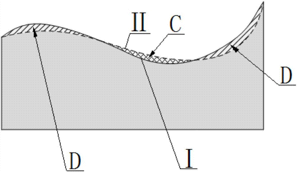
[0087] The present invention is described in detail by taking the data accuracy evaluation of real digital elevation model based on excavation analysis in a certain area as an example, and it also has guiding significance for the data accuracy evaluation of digital elevation model in other areas based on analysis of excavation and filling.

[0088] In this example, the DEM to be evaluated has a resolution of 10m, the reference system is CGCS2000_3_Degree_GK_CM_114E, and the grid size is 400*400; the geographical range is: Top, 3252005.6358; Left, 419993.330279; Right, 424003.330279; Bottom, 3247995.6358.

[0089] Step 1: Refer to DEM selection

[0090] Choose a high-precision DEM with the same spatial reference system as the DEM to be evaluated, with a larger area and a resolution of 1m as the reference DEM;

[0091] Step 2: Crop with reference to DEM

[0092]Limit the geographic range of the DEM to be evaluated, and clip the reference DEM. After clipping, the geographic rang...


PUM


Abstract

The invention discloses a digital elevation model accuracy evaluation method based on cut fill analysis. The method comprises the following steps that: selecting reference DEMs (Digital Elevation Model), and selecting the reference DEM which has the same accuracy with a DEM to be evaluated or the reference DEM which has higher accuracy; cutting the reference DEM, and enabling the reference DEM to be consistent with the geographical range of the DEM to be evaluated; calculating a resampling resolution, and calculating an optimal resampling resolution according to the resolution of the reference DEM and the DEM to be evaluated; carrying out DEM resampling, adopting the resampling resolution to carry out nearest neighbor resampling on the DEM to be evaluated and the reference DEM; calculating a cut fill volume difference, and calculating the sum of the volume difference of each resampled grid cell of the reference DEM and the DEM to be evaluated; and calculating a cut fill error, and dividing the cut fill volume difference by the area of the geographical range of the DEM. The method has the advantages that the scientificity and the practicality of the digital elevation model accuracy evaluation method can be improved.

Description

technical field [0001] The invention relates to the field of surveying and mapping, more specifically, it is a digital elevation model accuracy evaluation method based on fill-cut analysis. Background technique [0002] Digital elevation model (Digital Elevation Model, referred to as DEM) is the basic data source of spatial data infrastructure and digital earth construction, and it is widely used in scientific research and engineering practice involving three-dimensional geographic spatial location; the accuracy of digital elevation model data The level directly affects the feasibility, reliability and accuracy of various applications relying on it. Therefore, using a scientific model to analyze the accuracy and evaluate the quality of digital elevation model data is the basic premise to ensure its correct application. [0003] At present, for the accuracy evaluation method of the digital elevation model, the surveying and mapping industry adopts the elevation medium error ...

Claims


Application Information

Patent Timeline
Patent Type & Authority Applications(China)
IPC IPC(8): G06F17/50
CPCG06F30/00G06F2111/10
Inventor 徐志敏马瑞张力杨爱明
Owner 长江空间信息技术工程有限公司(武汉)
Learn More