Multi-parameter airborne LiDAR system error automatic calibration method

A system error and multi-parameter technology, applied to radio wave measurement systems, instruments, etc., can solve the problems of difficulty in extracting the same name point and low accuracy of calibration parameters, and achieve the effect of strict design, high calibration accuracy and real-time satisfaction

Inactive Publication Date: 2017-09-19
CHANGAN UNIV
View PDF3 Cites 9 Cited by
  • Summary
  • Abstract
  • Description
  • Claims
  • Application Information

AI Technical Summary

Problems solved by technology

[0005] The embodiment of the present invention provides a multi-parameter airborne LiDAR system error automatic calibration method, which is used to solve the problem in the prior art that it is difficult to extract the same name point from the discrete point cloud data, resulting in low calibration parameter accuracy.

Method used


Image

  • Multi-parameter airborne LiDAR system error automatic calibration method
  • Multi-parameter airborne LiDAR system error automatic calibration method
  • Multi-parameter airborne LiDAR system error automatic calibration method

Examples


Embodiment Construction

[0024] The technical solutions in the embodiments of the present invention will be clearly and completely described below in conjunction with the accompanying drawings in the embodiments of the present invention. Obviously, the described embodiments are only a part of the embodiments of the present invention, rather than all the embodiments. Based on the embodiments of the present invention, all other embodiments obtained by those of ordinary skill in the art without creative work shall fall within the protection scope of the present invention.

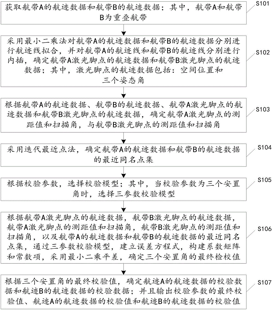
[0025] figure 1 It is a flowchart of a method for automatically checking and calibrating errors of a multi-parameter airborne LiDAR system provided by an embodiment of the present invention. Such as figure 1 As shown, the method includes:

[0026] Step S101: Obtain the track data of the flight belt A and the flight track data of the flight belt B; wherein, the flight belt A and the flight belt B are overlapping flight belts.

[0027] It sho...


PUM


Abstract

The invention discloses a multi-parameter airborne LiDAR system error automatic calibration method, and relates to the technical field of airborne LiDAR system error calibration. The multi-parameter airborne LiDAR system error automatic calibration method comprises the steps of acquiring flight path data of a flight strip A and a flight stripe B; respectively performing flight path fitting by adopting a least square method, respectively performing interpolation on flight path lines, and determining flight path data of laser foot points; determining a ranging value and a scanning angle of the laser foot points of the flight stripe A and a ranging value and a scanning angle of the laser foot points of the flight stripe B; determining a closest homonymous point set by adopting a iterative closest point method; selecting a calibration model according to calibration parameters; building an error equation according to the calibration model, building a coefficient matrix and a constant term, and determining final calibration values of three placement angles by adopting least square adjustment; and determining a calibration value of the flight path data according to the final calibration values of the three placement angles. According to the method, calibration is performed directly based on original point cloud data, the original point cloud data is not required to be interpolated into regular grid data or line features or surface features are not required to be extracted in advance, and the calibration accuracy is higher.

Description

Technical field [0001] The invention relates to the technical field of error checking and calibration of airborne LiDAR systems, and more specifically to a method for automatically checking and calibrating errors of multi-parameter airborne LiDAR systems. Background technique [0002] In actual production, the calibration of the airborne LiDAR system basically uses a profile-based manual calibration method provided by LiDAR equipment manufacturers with a certain degree of experience. The manual calibration method is more reliable, but more complex, the whole process is more cumbersome, time-consuming, labor-intensive, requires higher conditions for the calibration field, and insufficient accuracy statistics indicators. If the airborne LiDAR system is used for a rapid emergency response system, The time for manual calibration will greatly reduce its efficiency, and it is difficult to meet real-time and near-real-time requirements. Therefore, in actual production, there is an urge...

Claims


Application Information

Patent Timeline
Patent Type & Authority Applications(China)
IPC IPC(8): G01S7/497
CPCG01S7/497
Inventor 隋立春朱剑锋苏春艳钟棉卿
Owner CHANGAN UNIV
Why Eureka
Try Eureka