Method for monitoring forest land surface runoff volume and sediment loss amount
A technology for surface runoff and loss, applied in the measurement of flow/mass flow, liquid/fluid solid measurement, volume/mass flow generated by mechanical effects, etc. To achieve the effect of high promotion and use value, accurate monitoring data and low cost
- Summary
- Abstract
- Description
- Claims
- Application Information
AI Technical Summary
Problems solved by technology
Method used
Image

Examples
Embodiment 1
[0028] 1.1 Select monitoring forest land: select a piece of chestnut forest in Yangbei Village, Qingyuan County, Zhejiang Province with an area of 80m 2 The selected woodland is quadrilateral, 15m long, 5.3m wide, with basically the same slope aspect, with a slope of 20 degrees, and almost no understory vegetation.
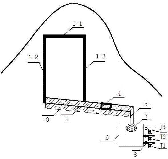
[0029]1.2 Construction of water retaining strips: first clear the forest land in the range of 30cm wide around the selected monitoring forest block, remove the weeds and litter on the ground, and take the upper boundary of the monitoring forest block as a reference. Dig a shallow ditch with a depth of 10-15cm and a width of 15-20cm on the upper boundary, left boundary and right boundary respectively, and bury the prepared water retaining strip with a width of 15-20cm in the ditch. The height requirement of the water retaining strip is 5-10 cm above the surface, and use soil to compact both sides of the water barrier to make it stand upright. The part buried in t...
Embodiment 2
[0038] 2.1 Select monitoring forest land: select a piece of land preparation area of 100m in a village fir forest in Liandu District, Zhejiang Province 2 The selected woodland is quadrilateral, 20m long and 5m wide, with basically the same slope aspect and a slope of 22 degrees.
[0039] 2.2 Construction of water retaining strips: first, clean up the forest land in the 40cm wide border around the selected monitoring forest block, remove small shrubs, Osmanthus, and weeds on the ground, and take the upper boundary of the monitoring forest block as a reference , dig a shallow ditch with a depth of 10-15cm and a width of 15-20cm on the upper boundary, left boundary and right boundary respectively, and bury the 1 / 2-2 / 3 part of the water retaining strip with a width of 15-20cm prepared in advance In the ditch, use soil to compact both sides of the water barrier to make it stand upright, and ensure that the surface runoff water outside the monitoring area cannot flow into the moni...
Embodiment 3
[0048] 3.1 Select the forest land for monitoring: select a piece of moso bamboo forest in a village in Songyang County, Zhejiang Province with an area of 90m 2 The selected woodland is a quadrilateral, 30m long and 3m wide, with basically the same slope direction, with a slope of 18 degrees, and the understory vegetation is weeds.
[0049] 3.2 Construction of water-retaining strips: first, clean up the forest land in the 40cm wide border around the selected monitoring forest block, remove small shrubs, Osmanthus, and weeds on the ground, and take the upper boundary of the monitoring forest block as a reference , dig a shallow ditch with a depth of 10-15cm and a width of 15-20cm on the upper boundary, left boundary and right boundary respectively, and bury the 1 / 2-2 / 3 part of the water retaining strip with a width of 15-20cm prepared in advance In the ditch, use soil to compact both sides of the water barrier to make it stand upright, and ensure that the surface runoff water ...
PUM
| Property | Measurement | Unit |
|---|---|---|
| Diameter | aaaaa | aaaaa |
| Diameter | aaaaa | aaaaa |
Abstract
Description
Claims
Application Information
 - R&D Engineer
- R&D Manager
- IP Professional
- Industry Leading Data Capabilities
- Powerful AI technology
- Patent DNA Extraction
Browse by: Latest US Patents, China's latest patents, Technical Efficacy Thesaurus, Application Domain, Technology Topic.
© 2024 PatSnap. All rights reserved.Legal|Privacy policy|Modern Slavery Act Transparency Statement|Sitemap