Virtual scanning and ranging matching-based AGV laser SLAM method

A virtual scanning and laser technology, applied in two-dimensional position/channel control, non-electric variable control, instruments, etc., can solve the problem of filtering, estimation stability and positioning accuracy cannot be absolutely guaranteed, and it is difficult to meet the application requirements of industrial AGV robots, etc. question

Inactive Publication Date: 2017-10-10
仲训昱
View PDF4 Cites 36 Cited by
  • Summary
  • Abstract
  • Description
  • Claims
  • Application Information

AI Technical Summary

Problems solved by technology

[0013] The purpose of the present invention is to solve the problem that most of the existing laser SLAM algorithms are aimed at low-precision sensors, and the stability of filtering, est...

Method used


Image

  • Virtual scanning and ranging matching-based AGV laser SLAM method
  • Virtual scanning and ranging matching-based AGV laser SLAM method
  • Virtual scanning and ranging matching-based AGV laser SLAM method

Examples


Embodiment 1

[0050] Embodiment 1: The SLAM method based on virtual scanning and ranging matching in the present invention is used for offline mapping, and the specific implementation process is as follows.

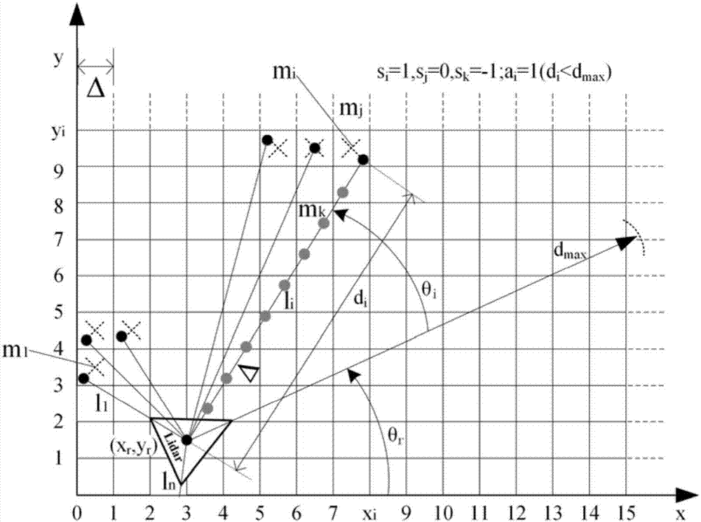
[0051] Step 1: Use remote control or other manual operation methods to control the AGV robot to walk in the working environment, and the laser radar collects and saves all moments (t 0 to t end ) ranging information {d 1 , d 2 ,...,d n}|t 0 、{d 1 , d 2 ,...,d n}|t 1 ,...,{d 1 , d 2 ,...,d n}|t end .

[0052] Step 2: Using appropriate data format and files, define the grid map M shown in formula (1), and initialize it.

[0053] Step 3: From t 0 start time to t end At the end moment, use the ranging information to build a map, the steps are as follows.

[0054] Step 3.1: For the initial time t 0 , the initial pose of the lidar is known, according to formula (2) {d 1 , d 2 ,...,d n}|t 0 Convert to L t0 , and then according to formula (3) L t0 Mapped to the grid map ...

Embodiment 2

[0058] Embodiment 2: After offline mapping, the present invention is used for real-time positioning of an AGV robot with a map, and the specific implementation process is as follows.

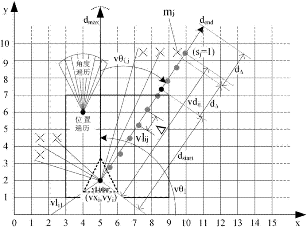
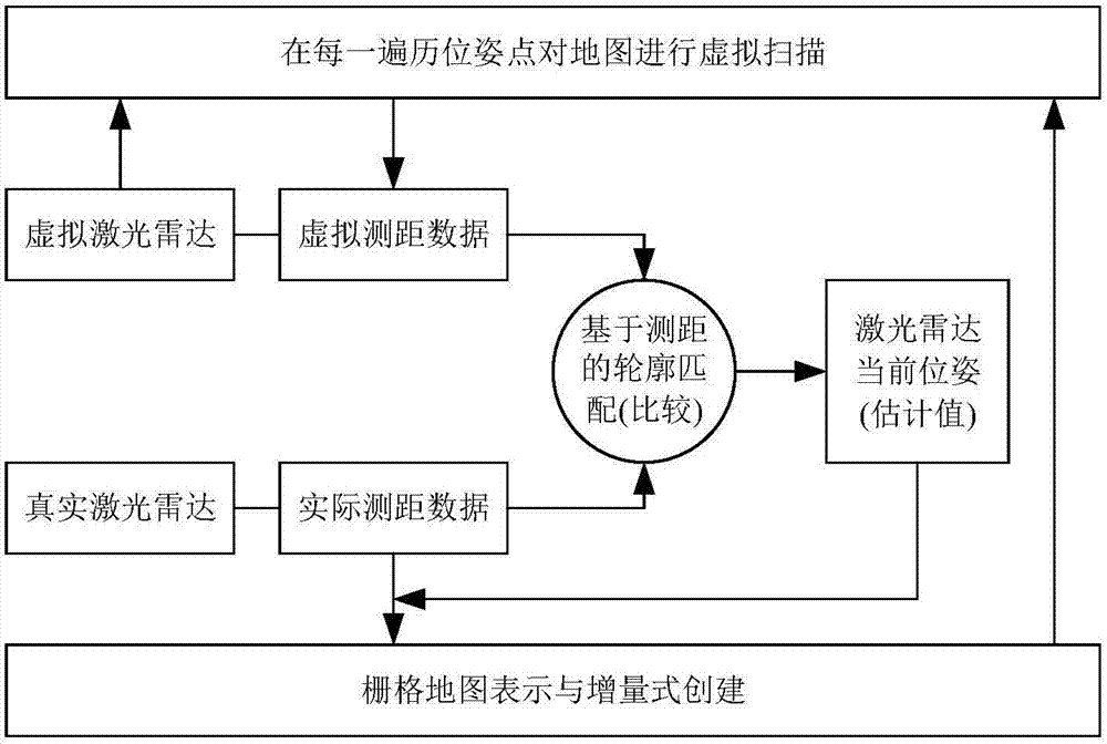
[0059] Step 1: At the current moment, the lidar obtains the ranging information {d 1 , d 2 ,...,d n}, according to formula (2) put {d 1 , d 2 ,...,d n} is converted to L.

[0060] Step 2: For each pose in the traversal range Ω, simulate the laser radar to scan the map M (using multi-GPU parallel processing and advancing ranging algorithm, each GPU corresponds to a laser scanning direction), and obtain virtual scanning data VSs( Ω)={L 1 , L 2 ,...,L i ,...,L K}.

[0061] Step 3: Put the data VSs(Ω)={L 1 , L 2 ,...,L i ,...,L K} is compared with L, find out the virtual scanning data L* closest to L according to formula (5);

[0062] Step 4: According to L* and formula (6), obtain the estimated value of the current position and orientation of the lidar (that is, positioning).

Embodiment 3

[0063] Embodiment 3: The SLAM method based on virtual scanning and ranging matching in the present invention is directly used for real-time concurrent mapping and positioning, and the specific implementation process is as follows.

[0064] Step 1: Adopt the appropriate data format and file, define the grid map M shown in formula (1), and initialize it.

[0065] Step 2: For the initial time t 0 , the initial pose of the lidar is known, according to formula (2) the ranging {d 1 , d 2 ,...,d n}|t 0 Convert to L t0 , and then according to formula (3) L t0Mapped to the grid map M;

[0066] Step 3: At the next current moment, the lidar obtains the ranging information {d 1 , d 2 ,...,d n}, according to formula (2) put {d 1 , d 2 ,...,d n} is converted to L.

[0067] Step 4: For each pose in the traversal range Ω, simulate the lidar to scan the map M (using multi-GPU parallel processing and advancing ranging algorithm, each GPU corresponds to a laser scanning direction), ...


PUM


Abstract

The invention discloses a virtual scanning and ranging matching-based AGV laser SLAM method, and relates to mobile robot navigation and positioning. The method comprises a grid map representation and establishment method, a virtual scanning and matching positioning method and an algorithm instantaneity improving method. The method using a contour traversal matching principle comprises the specific steps of scanning a map by adopting a virtual laser radar at each traversal position, directly comparing virtually scanned data with data of a current laser radar, finding out optimal position information of an AGV robot and then incrementally building the map. For the problems that most of existing laser SLAM algorithms are aimed at a low-precision sensor, and the filtering, estimating and optimizing stability and the positioning accuracy cannot be absolutely ensured and the application requirements of the industrial AGV robot cannot be easily met, the problem of preliminary construction and calibration in navigation by adopting a reflector board and a triangulation principle can be solved by adopting multi-GPU parallel processing and changing an initial propulsion position of virtual ranging, and the flexibility, the reliability and the precision are improved.

Description

technical field [0001] The invention relates to mobile robot navigation and positioning, in particular to a SLAM (simultaneous positioning and map construction) method of a trackless navigation AGV robot based on 2D laser radar. Background technique [0002] Simultaneous positioning and map construction (or concurrent mapping and positioning) (Simultaneous Localization AndMapping, SLAM) is a key technology to realize a truly fully autonomous mobile robot. Traditional AGV (Automated Guided Vehicle) navigation mainly includes magnetic strip guidance, magnetic nail guidance, ribbon or two-dimensional code guidance, etc. Although it is simple and easy to implement and has good path tracking reliability, they all belong to the fixed path guidance method and are flexible. Poor sex and flexibility. The new laser navigation method does not require fixed route guidance, and has higher flexibility in application. However, most of the current laser navigation methods use reflectors an...

Claims


Application Information

Patent Timeline
IPC IPC(8): G05D1/02
CPCG05D1/0257G05D1/0276
Inventor 仲训昱
Owner 仲训昱
Why Eureka
Try Eureka