High-resolution video satellite imaging system

An imaging system and high-resolution technology, applied in the field of video satellite imaging systems, to increase the integration time, reduce the requirements of attitude stability, and reduce the volume.

Inactive Publication Date: 2017-10-20
CHANGCHUN INST OF OPTICS FINE MECHANICS & PHYSICS CHINESE ACAD OF SCI
View PDF3 Cites 6 Cited by
  • Summary
  • Abstract
  • Description
  • Claims
  • Application Information

AI Technical Summary

Problems solved by technology

[0004] The present invention provides a high-resolution video satellite imaging system based on space applications in order to solve the technical problem to be solved by the present invention in order to solve the feasibility and reliability of the existing high-spatial resolution and large-width video imaging aerospace applications

Method used


Image

  • High-resolution video satellite imaging system
  • High-resolution video satellite imaging system
  • High-resolution video satellite imaging system

Examples


specific Embodiment approach 1

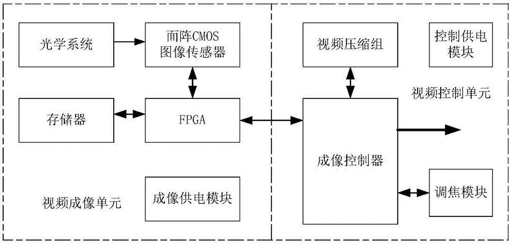
[0012] Specific implementation mode 1. Combination figure 1 To illustrate this embodiment, the high-resolution video satellite imaging system mainly consists of two parts: a video imaging unit and a video control unit. The video imaging unit mainly includes optical system, area array CMOS image sensor, FPGA, memory and imaging power supply module; the video control unit mainly includes imaging controller, video compression group, focusing module and control power supply module. The optical system images the ground scene onto the area array CMOS image sensor. The imaging power supply module supplies power to the area array CMOS image sensor, FPGA and memory respectively, and is controlled by the video control unit to output the working voltage that satisfies the overall or rolling shutter working mode of the area array CMOS image sensor. FPGA realizes the register configuration of the area array CMOS image sensor in the global or rolling shutter working mode, generates corresp...


PUM


Abstract

The invention discloses a high-resolution video satellite imaging system, and relates to a video satellite imaging system, for solving the technical problems about feasibility and reliability of spaceflight application of video imaging with a high spatial resolution and a large breadth. The system comprises a video imaging unit and a video control unit, wherein the video imaging unit comprises an optical system, an area array CMOS image sensor, an FPGA, a storage and an imaging power supply module; the imaging power supply module powers the area array MCOS image sensor, the FPGA and the storage; the video control unit comprises an imaging controller, a video compression set, a focusing module and a power supply control module, and the power supply control module powers the imaging controller, the video compression set and the focusing module. According to the system provided by the invention, the exposure time interval of the whole frame is shortened in an overall shutter working mode, the requirement on posture stability during a satellite swinging process is reduced, the use of a focal image shift compensation mechanism is cancelled, the volume is reduced, the weight is decreased, and no moving components exist, so that reliability of the spaceflight application is improved.

Description

technical field [0001] The invention relates to a video satellite imaging system, in particular to a high-resolution and large-width video satellite imaging system with a ground pixel resolution better than 0.5m and a width not lower than 4km×4km. Background technique [0002] Video satellite is a new type of earth observation satellite. Compared with traditional earth observation satellites, its biggest feature is that it can "stare" at a certain area. The so-called "staring" means that with the movement of the satellite, the optical imaging system always keeps an eye on a certain target area, and can continuously observe changes in the field of view. There are two main ways to achieve "staring". One is to use geostationary orbit optical imaging satellites, and the other is to use low-orbit optical imaging satellites with high attitude agility or image motion compensation capabilities. Due to the dynamic characteristics of the orbit, the satellite in geostationary orbit is...

Claims


Application Information

Patent Timeline
Patent Type & Authority Applications(China)
IPC IPC(8): H04N5/235H04N5/353H04N5/355H04N5/374
CPCH04N23/73H04N25/531H04N25/583H04N25/768H04N25/76
Inventor 余达梅贵巩盾刘金国徐东李广泽闫得杰
Owner CHANGCHUN INST OF OPTICS FINE MECHANICS & PHYSICS CHINESE ACAD OF SCI
Why Eureka
Try Eureka